Regiones

Last updated

Regiones (singular: regio) or provinciae,(singular: provincia), [1] also referred to by historians as small shires or early folk territories, [2] were early territorial divisions of Anglo-Saxon England, referred to in sources such as Anglo-Saxon charters and the writings of Bede. [3] They are likely to have originated in the years before 600, and most evidence for them occurs in sources from or about the 7th century. [3]

Contents

Regiones were self-sufficient units of mixed subsistence agriculture [4] consisting of scattered settlements producing the range of foodstuffs and other forms of produce necessary to support their population. [5] They formed the defined territories of tribes or similar social groupings and were the building-blocks around which the larger Anglo-Saxon kingdoms were governed. [6]

Regiones gradually fragmented in the later Anglo-Saxon period as land was granted into private or ecclesiastical ownership by charter, and the smaller manors that emerged were gradually re-organised for military purposes into hundreds and the larger shires that later evolved into counties. The patterns of obligation that characterised regiones were often retained between successor manors, however, and their traces can be seen in many of the sokes, thanages, liberties, baronies and other administrative and ecclesiastic divisions that characterised later medieval society. [7]

Some historians have identified regiones with the concept of the Anglo-Saxon multiple estate. Others have argued that, while similarly organised, multiple estates represent a later stage of territorial organisation, after the concept of folkland or tribal occupation and obligation began to be replaced by that of bookland or documented private ownership. [8]

Naming and areas

Primary historical sources refer to these areas exclusively in Latin as regiones or provinciae and it is not known what the equivalent contemporary Old English term would have been. [1] Several different terms were used when original Latin texts were later translated, including -ge, which meant "district" and survived as the second element of the names of several regiones including Eastry and Ely; [1] and meagth, which meant "kindred", suggesting the areas had tribal origins. [1]

In areas of Jutish settlement - such as the Kingdom of Kent and the area around the Solent - regiones often took the name of a topographical element with the Old English suffix "-wara" meaning "-dwellers". [9] Examples include the Wihtwara of the Isle of Wight, the Meonwara of the area around the River Meon in south Hampshire, the Limenwara around the River Rother (formerly known as the Limen) in Kent. [10]

Similar units with names ending in "-ingas" meaning "people of..." can be found in areas of Saxon settlement. [9] Examples in Wessex include the areas of the Readingas , Sunningas and Basingas around Reading, Sonning and Basingstoke. [9] In the Kingdom of Essex examples have been identified including the Berecingas around Barking, the Haeferingas of modern Havering, the Uppingas of Epping and the Hrothingas that occupied the area of the modern Rodings. [11]

Examples in areas of Anglian settlement include the Blithingas around Blythburgh in the Kingdom of East Anglia. [12] Many of the smaller areas mentioned in the Tribal Hidage are likely to have been regiones. [13]

Within the area of the Kingdom of Northumbria regiones were often named after their central place with the Old English suffix "-scīr" – for example Hallamshire or Hexhamshire – which has led historians to refer to them as "small shires" to distinguish them from the later shires that evolved into the historic counties of England. [14]

Origins

Various explanations exist for how these territorial units may have formed in the 5th and 6th centuries. [15] The first elements in names ending in -ingas have often been interpreted as personal names, and the territories have often been seen as the areas settled by families or tribes led by those named individuals, or perhaps with them as their earliest known common ancestor. [15] This view sees regiones as the areas of previously autonomous tribal groupings, that retained their identity when absorbed into larger kingdoms in the later 6th and 7th centuries, coming to pay tribute to a king rather than an earlier tribal chieftain. [16]

Alternatively regiones may have formed from earlier units based around centres such as hillforts in the aftermath of the end of Roman rule in Britain, subsequently transferred to Anglo-Saxon rulers. [17] Some regiones carry evidence of continuity with earlier Roman or pre-Roman subdivisions, including that of the Brahhingas , which was based around Braughing in modern Hertfordshire, the site of both an earlier Iron Age oppidum and a large Roman town. [18] This would suggest that regiones succeeded the Roman subdivisions of civitates known as pagi . [19]

Many small shires have been identified in the area of the south east of modern Scotland that was under Northumbrian control during the early medieval period, but many with identical features have also been identified north of the River Forth in areas that were never under Anglo-Saxon or Roman rule, suggesting that the territories may have even earlier Celtic origins. [20]

Structure and role

Regiones were characterised by well-defined areas, [21] generally of the order of 100 square miles (26,000 ha) [20] and often made up of 12 vills. [22] They generally conformed to local topography, occupying a geographically coherent area such as a defined stretch of a river valley. [23] They constituted self-contained and organised economic units of subsistence agriculture [24] including a diverse range of scattered settlements practising a mix of arable and pastoral farming [23] and sharing common grazing land. [25]

Regiones were typically centred upon a royal vill. [21] Anglo-Saxon England lacked the high volume trade in essential foodstuffs necessary to sustain a large royal household in a single location. [26] Royal vills therefore formed a network of halls and accommodation across a kingdom through which a royal household would tour in an itinerary, where each regio would provide food renders to support the royal household and from where the regio and the wider kingdom would be administered. [27]

Where they are recorded in charters or by Bede the rulers of regiones are referred to as principes (princes), reguli (kings) or subreguli (sub-kings). [28]

Later territorial continuity

The regio as a basic territorial unit gradually fragmented during the later Anglo Saxon period as the concept of tribal ownership and organisation declined and was replaced with the concept of private land-holding. [29] The smaller manors that characterise the Domesday Book emerged from within regiones through the endowment of churches with land, the rewarding of officials and the division of a family's land among inheritors. [30]

In Kent the areas of the regiones survived as the lathes into which the later county was subdivided. [31] The rapes of Sussex, which similarly each included several hundreds, may also reflect the regiones that made up the earlier Kingdom. [32]

Away from those areas traces of earlier regiones can be found where later groups of hundreds contributed to a single royal manor. [33] In 1066 the 19 hundreds of Oxfordshire were annexed in this manner to 7 royal manors that included Headington, Kirtlington and Bensington. [34] In Berkshire and north Hampshire the regio centres of Reading, Sonning and Basingstoke remained centres of distinctive groupings of hundreds throughout the Middle Ages, [15] with the "Six hundreds of Basingstoke" and the "Seven hundreds of Cookham and Bray" referred to in medieval records closely resembling the earlier territories of the Basingas and Sunningas . [35] The Surrey hundreds of Chertsey and Woking correspond to the earlier territory of the Woccingas . [14]

The defined territories of regiones also formed the basis for later ecclesiastic geography. Conversion to christianity was frequently followed by the establishment of a minster for the tribe, with the boundaries of the tribe's territory frequently defining the minster parishes which the minsters served. [21]

Related Research Articles

<span class="mw-page-title-main">Kingdom of Essex</span> Former kingdom on the island of Britain (527–825 CE)

The Kingdom of the East Saxons, referred to as the Kingdom of Essex, was one of the seven traditional kingdoms of the Anglo-Saxon Heptarchy. It was founded in the 6th century and covered the territory later occupied by the counties of Essex, Middlesex, much of Hertfordshire and west Kent. The last king of Essex was Sigered of Essex, who in 825 ceded the kingdom to Ecgberht, King of Wessex.

<span class="mw-page-title-main">Mercia</span> One of the kingdoms of the Anglo-Saxon Heptarchy (527–918)

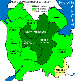
Mercia was one of the three notable Anglic kingdoms founded after Sub-Roman Britain was settled by Anglo-Saxons in an era called the Heptarchy. It was centred around the River Trent and its tributaries, in a region now known as the Midlands of England.

<span class="mw-page-title-main">Ecgberht, King of Wessex</span> 8th and 9th-century Anglo-Saxon King of Wessex

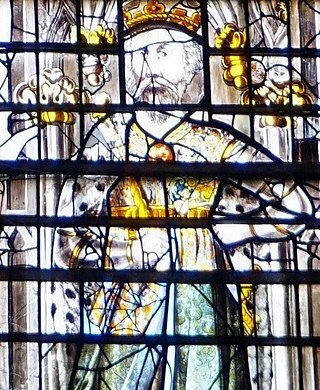
Ecgberht, also spelled Egbert, Ecgbert, Ecgbriht, Ecgbeorht, and Ecbert, was King of Wessex from 802 until his death in 839. His father was King Ealhmund of Kent. In the 780s, Ecgberht was forced into exile to Charlemagne's court in the Frankish Empire by the kings Offa of Mercia and Beorhtric of Wessex, but on Beorhtric's death in 802, Ecgberht returned and took the throne.

<span class="mw-page-title-main">Ine of Wessex</span> King of Wessex

Ine, also rendered Ini or Ina, was King of Wessex from 689 to 726. At Ine's accession, his kingdom dominated much of southern England. However, he was unable to retain the territorial gains of his predecessor, Cædwalla, who had expanded West Saxon territory substantially. By the end of Ine's reign, the kingdoms of Kent, Sussex, and Essex were no longer under West Saxon sway; however, Ine maintained control of what is now Hampshire, and consolidated and extended Wessex's territory in the western peninsula.

<span class="mw-page-title-main">Anna of East Anglia</span> King of the East Angles

Anna was king of East Anglia from the early 640s until his death. He was a member of the Wuffingas family, the ruling dynasty of the East Angles, and one of the three sons of Eni who ruled the kingdom of East Anglia, succeeding some time after Ecgric was killed in battle by Penda of Mercia. Anna was praised by Bede for his devotion to Christianity and was renowned for the saintliness of his family: his son Jurmin and all his daughters – Seaxburh, Æthelthryth, Æthelburh and possibly a fourth, Wihtburh – were canonised.

The hide was an English unit of land measurement originally intended to represent the amount of land sufficient to support a household. It was traditionally taken to be 120 acres , but was in fact a measure of value and tax assessment, including obligations for food-rent, maintenance and repair of bridges and fortifications, manpower for the army, and (eventually) the geld land tax. The hide's method of calculation is now obscure: different properties with the same hidage could vary greatly in extent even in the same county. Following the Norman Conquest of England, the hidage assessments were recorded in the Domesday Book of 1086, and there was a tendency for land producing £1 of income per year to be assessed at 1 hide. The Norman kings continued to use the unit for their tax assessments until the end of the 12th century.

<span class="mw-page-title-main">The Rodings</span>

The Rodings are a group of eight villages in the upper part of the River Roding and the west of Essex, England, the largest group in the country to bear a common name. The Rodings do not lie within a single district in the county; they are arranged around the tripoint of the administrative areas of Chelmsford, Uttlesford and Epping Forest. An alternative arcane name, linked to the Middle English Essex dialect, was The Roothings.

<span class="mw-page-title-main">Tribal Hidage</span> List of thirty-five Anglo-Saxon tribes

The Tribal Hidage is a list of thirty-five tribes that was compiled in Anglo-Saxon England some time between the 7th and 9th centuries. It includes a number of independent kingdoms and other smaller territories, and assigns a number of hides to each one. The list is headed by Mercia and consists almost exclusively of peoples who lived south of the Humber estuary and territories that surrounded the Mercian kingdom, some of which have never been satisfactorily identified by scholars. The value of 100,000 hides for Wessex is by far the largest: it has been suggested that this was a deliberate exaggeration.

<span class="mw-page-title-main">Medeshamstede</span> Anglo-Saxon name of Peterborough, England

Medeshamstede was the name of Peterborough in the Anglo-Saxon period. It was the site of a monastery founded around the middle of the 7th century, which was an important feature in the kingdom of Mercia from the outset. Little is known of its founder and first abbot, Sexwulf, though he was himself an important figure, and later became bishop of Mercia. Medeshamstede soon acquired a string of daughter churches, and was a centre for an Anglo-Saxon sculptural style.

The Basingas were an Old English tribe, whose territory in the Loddon Valley formed a regio or administrative subdivision of the early Kingdom of Wessex. Their leader, Basa, gave the tribe its name which survives in the names of Old Basing and Basingstoke, both in Hampshire.

<span class="mw-page-title-main">Pecsaetan</span>

The Pecsætan, also called Peaklanders or Peakrills in modern English, were an Anglo-Saxon tribe who inhabited the central and northern parts of the Peak District area in England.

<span class="mw-page-title-main">Edward the Elder</span> King of the Anglo-Saxons from 899 to 924

Edward the Elder was King of the Anglo-Saxons from 899 until his death in 924. He was the elder son of Alfred the Great and his wife Ealhswith. When Edward succeeded to the throne, he had to defeat a challenge from his cousin Æthelwold, who had a strong claim to the throne as the son of Alfred's elder brother and predecessor, Æthelred I.

<span class="mw-page-title-main">Middle Angles</span> Cultural sub-group of the Anglo-Saxons

The Middle Angles were an important ethnic or cultural group within the larger kingdom of Mercia in England in the Anglo-Saxon period.

<span class="mw-page-title-main">Kingdom of East Anglia</span> Anglo-Saxon kingdom in southeast Britain (6th century – 918)

The Kingdom of the East Angles, today known as the Kingdom of East Anglia, was a small independent kingdom of the Angles comprising what are now the English counties of Norfolk and Suffolk and perhaps the eastern part of the Fens. The kingdom formed in the 6th century in the wake of the Anglo-Saxon settlement of Britain. It was ruled by the Wuffingas dynasty in the 7th and 8th centuries, but fell to Mercia in 794, and was conquered by the Danes in 869, to form part of the Danelaw. It was conquered by Edward the Elder and incorporated into the Kingdom of England in 918.

The Beormingas were a tribe or clan in Anglo-Saxon England, whose territory possibly formed a regio or early administrative subdivision of the Kingdom of Mercia. The name literally means "Beorma's people" in Old English, and Beorma is likely to have been either the leader of the group during its settlement in Britain or a real or legendary tribal ancestor. The name of the tribe is recorded in the place name Birmingham, which means "home of the Beormingas".

<span class="mw-page-title-main">Mercian Supremacy</span> Period of history when the kingdom of Mercia dominated in England

The Mercian Supremacy was the period of Anglo-Saxon history between c. 716 and c. 825, when the kingdom of Mercia dominated the Anglo-Saxon Heptarchy in England. Sir Frank Stenton apparently coined the phrase, arguing that Offa of Mercia, who ruled 757–796, effectively achieved the unification of England south of the Humber estuary. Scholastic opinion on the relationship between the kingdoms of Wessex and Mercia at this time remains divided.

A royal vill, royal tun or villa regalis was the central settlement of a rural territory in Anglo Saxon England, which would be visited by the King and members of the royal household on regular circuits of their kingdoms. The royal vill was the centre for the administration of a subdivision of a kingdom, and the location where the subdivision would support the royal household through the provision of food rent. Royal vills have been identified as the centres of the regiones of the early Anglo-Saxon period, and of the smaller multiple estates into which regiones were gradually divided by the 8th century.

Food render or food rent was a form of tax in kind levied in Anglo-Saxon England, consisting of essential foodstuffs provided by territories such as regiones, multiple estates or hundreds to kings and other members of royal households at a territory's royal vill.

The Brahhingas or Brahingas were a tribe or clan of Anglo-Saxon England whose territory was centred on the settlement of Braughing in modern-day Hertfordshire. The name of the tribe means "the people of Brahha", with Brahha likely to have been either a leader of the tribe or a real or mythical ancestor.

The Waeclingas were a tribe or clan of Anglo-Saxon England. Their territory or regio was based in the modern city of St Albans, whose name is recorded as Wæclingaceaster in the writings of Bede in the early 8th century, and in an early 10th century Anglo-Saxon charter. Before the territory came under Mercian control around 660 it may have formed part of the province of the Middle Saxons, or it may have fallen under the influence of the Kingdom of Essex – neither is certain.

References

  1. 1 2 3 4 Stenton 1971, p. 293.
  2. Rippon 2012, pp. 188, 190.
  3. 1 2 Yorke 1995, p. 39.
  4. Faith 1999, pp. 3–5.
  5. Faith 1999, p. 9.
  6. Faith 1999, pp. 5–8.
  7. Faith 1999, p. 8.
  8. Rippon 2012, p. 151.
  9. 1 2 3 Yorke 1995, p. 40.
  10. Yorke 1995, pp. 40, 41.
  11. Bailey 1989, p. 121.
  12. Williamson 2013, p. 83.
  13. Stenton 1971, p. 295.
  14. 1 2 Thornton 2009, p. 93.
  15. 1 2 3 Yorke 1995, p. 42.
  16. Williamson 2013, pp. 82–83.
  17. Yorke 1995, pp. 42–43.
  18. Williamson 2013, pp. 83–84.
  19. Rippon 2012, p. 191.
  20. 1 2 Campbell 2008, p. 32.
  21. 1 2 3 Bassett 1989, p. 19.
  22. Campbell 2008, p. 40.
  23. 1 2 Faith 1999, pp. 3–4.
  24. Bassett 1989, p. 21.
  25. Campbell 2008, pp. 32, 35.
  26. Charles-Edwards 1989, p. 28.
  27. Charles-Edwards 1989, pp. 28–29.
  28. Bassett 1989, p. 17.
  29. Bassett 1989, p. 20.
  30. Bassett 1989, pp. 19–20.
  31. Stenton 1971, p. 503.
  32. Stenton 1971, p. 504.
  33. Stenton 1971, p. 300.
  34. Stenton 1971, pp. 300–301.
  35. Stenton 1971, p. 301.

Bibliography