
A geographic information system (GIS) is a type of database containing geographic data, combined with software tools for managing, analyzing, and visualizing those data. In a broader sense, one may consider such a system to also include human users and support staff, procedures and workflows, body of knowledge of relevant concepts and methods, and institutional organizations.
Remote sensing is the acquisition of information about an object or phenomenon without making physical contact with the object, in contrast to in situ or on-site observation. The term is applied especially to acquiring information about Earth and other planets. Remote sensing is used in numerous fields, including geography, land surveying and most Earth science disciplines ; it also has military, intelligence, commercial, economic, planning, and humanitarian applications, among others.
In-Q-Tel (IQT), formerly Peleus and In-Q-It, is an American not-for-profit venture capital firm based in Arlington, Virginia. It invests in high-tech companies to keep the Central Intelligence Agency, and other intelligence agencies, equipped with the latest in information technology in support of United States intelligence capability. The name "In-Q-Tel" is an intentional reference to Q, the fictional inventor who supplies technology to James Bond.

NASA WorldWind is an open-source virtual globe. According to the website, "WorldWind is an open source virtual globe API. WorldWind allows developers to quickly and easily create interactive visualizations of 3D globe, map and geographical information. Organizations around the world use WorldWind to monitor weather patterns, visualize cities and terrain, track vehicle movement, analyze geospatial data and educate humanity about the Earth." It was first developed by NASA in 2003 for use on personal computers and then further developed in concert with the open source community since 2004. As of 2017, a web-based version of WorldWind is available online. An Android version is also available.

Satellite images are images of Earth collected by imaging satellites operated by governments and businesses around the world. Satellite imaging companies sell images by licensing them to governments and businesses such as Apple Maps and Google Maps.
A GIS software program is a computer program to support the use of a geographic information system, providing the ability to create, store, manage, query, analyze, and visualize geographic data, that is, data representing phenomena for which location is important. The GIS software industry encompasses a broad range of commercial and open-source products that provide some or all of these capabilities within various information technology architectures.
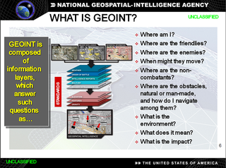
In the United States, geospatial intelligence (GEOINT) is intelligence about the human activity on earth derived from the exploitation and analysis of imagery, signals, or signatures with geospatial information. GEOINT describes, assesses, and visually depicts physical features and geographically referenced activities on the Earth. GEOINT, as defined in US Code, consists of imagery, imagery intelligence (IMINT) and geospatial information.
Business intelligence software is a type of application software designed to retrieve, analyze, transform and report data for business intelligence. The applications generally read data that has been previously stored, often - though not necessarily - in a data warehouse or data mart.
The Open Source Geospatial Foundation (OSGeo), is a non-profit non-governmental organization whose mission is to support and promote the collaborative development of open geospatial technologies and data. The foundation was formed in February 2006 to provide financial, organizational and legal support to the broader Free and open-source geospatial community. It also serves as an independent legal entity to which community members can contribute code, funding and other resources.

The Geospatial Data Abstraction Library (GDAL) is a computer software library for reading and writing raster and vector geospatial data formats, and is released under the permissive X/MIT style free software license by the Open Source Geospatial Foundation. As a library, it presents a single abstract data model to the calling application for all supported formats. It may also be built with a variety of useful command line interface utilities for data translation and processing. Projections and transformations are supported by the PROJ library.
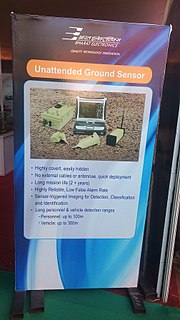
The unattended ground sensor (UGS) is under development as part of the United States Army's Future Combat Systems Program. For information on currently fielded UGS systems, refer to the Current Force UGS Program or CF UGS.
Bhuvan,, is an Indian web based utility which allows users to explore a set of map based content prepared by Indian Space Research Organisation. The content which the utility serves is mostly restricted to Indian boundaries and is offered in 4 regional languages. The content includes thematic maps related to disasters, agriculture, water resources, land cover and also processed satellite data of ISRO. Bhuvan is known for its association with various sections of Government of India to enable the use of Geospatial technology. Bhuvan has since its inception enabled Indian government to host public geospatial data as Information layers for visualisation and public consumption. Examples of the types of geospatial layers include Toll Information System for National Highways Authority of India, Islands information System for MHA, Cultural heritage sites for Ministry of culture etc. The information for the platform is obtained from the government of India sources or through Crowdsourcing.
IMAGINE Photogrammetry is a software application for performing photogrammetric operations on imagery and extracting information from imagery. IMAGINE Photogrammetry is significant because it is a leading commercial photogrammetry application that is used by numerous national mapping agencies, regional mapping authorities, various DOTs, as well as commercial mapping firms. Aside from commercial and government applications, IMAGINE Photogrammetry is widely used in academic research. Research areas include landslide monitoring, cultural heritage studies, and more.

The Remote Sensing Center (RSC) at the Naval Postgraduate School was established to bring together a range of capabilities and expertise to address problems of military and intelligence importance, as well as environmental and civil concerns. It is specialized in a variety of remote sensing technologies designed to enable people to look beyond the range of human vision in range or in spectral perception.
L3Harris Geospatial develops products for the visualization, analysis, and management of geospatial imagery and scientific data. The company develops products such as IDL, ENVI, and Jagwire which are used in a variety of industries including defense and intelligence, environmental, engineering, aerospace, medical imaging, and federal and civil governments worldwide.
Geographic information systems (GIS) play a constantly evolving role in geospatial intelligence (GEOINT) and United States national security. These technologies allow a user to efficiently manage, analyze, and produce geospatial data, to combine GEOINT with other forms of intelligence collection, and to perform highly developed analysis and visual production of geospatial data. Therefore, GIS produces up-to-date and more reliable GEOINT to reduce uncertainty for a decisionmaker. Since GIS programs are Web-enabled, a user can constantly work with a decision maker to solve their GEOINT and national security related problems from anywhere in the world. There are many types of GIS software used in GEOINT and national security, such as Google Earth, ERDAS IMAGINE, GeoNetwork opensource, and Esri ArcGIS.
Edge Development Option (EDO) comprises a set of C++ computer libraries produced by Boeing that allows to quickly build 2D and 3D visualization software similar to Google Earth, in order to display satellite imagery and create virtual scenarios for displaying sensor, 3D models, 4D (time-dependent) tracks and for line-of-sight and smart volume analysis. EDO is a toolkit based on EDGE Whole Earth, a software program developed by a company named Autometric, now part of Boeing. While EDGE was initially mainly developed for SGI machines, EDO is mainly Windows-based. EDO retained much of EDGE's functionality but allowed greater flexibility for developers, i.e. the ability to integrate EDO functionality into their own application leveraging on EDO's libraries. Google Earth is the more famous heir to the 3D applications EDGE and EDO.
In science, the concept of a macroscope is the antithesis of the microscope, namely a method, technique or system by which a very large object can be observed, for example the Earth and its contents, or conceptually, the Universe. Obviously, a single system or instrument does not presently exist that could fulfil this function, however its concept may be approached by some current or future combination of existing observational systems. The term "macroscope" has also been applied to a method or compendium which can view some more specific aspect of global scientific phenomena in its entirety, such as all plant life, specific ecological processes, or all life on earth. The term has also been used in the humanities, as a generic label for tools which permit an overview of various other forms of "big data". As discussed here, the concept of a "macroscope" differs in essence from that of the macroscopic scale, which simply takes over from where the microscopic scale leaves off, covering all objects large enough to be visible to the unaided eye, as well as from macro photography, which is the imaging of specimens at magnifications greater than their original size, and for which a specialised microscope-related instrument known as a "Macroscope" has previously been marketed. For some workers, one or more "macroscopes" can already be constructed, to access the sum of relevant existing observations, while for others, deficiencies in current sampling regimes and/or data availability point to additional sampling effort and deployment of new methodologies being required before a true "macroscope" view of Earth can be obtained.
