Reute

Last updated • 4 min readFrom Wikipedia, The Free Encyclopedia
Reute
Hl Michael in Reute, Hittisau 1.JPG
Reute.jpg
Location of Reute
Reute
Switzerland adm location map.svg
Red pog.svg
Reute
Reliefkarte Appenzell Ausserrhoden blank.png
Red pog.svg
Reute
Coordinates: 47°25′N9°35′E / 47.417°N 9.583°E / 47.417; 9.583
Country Switzerland
Canton Appenzell Ausserrhoden
District n.a.
Area
[1]
  Total
4.99 km2 (1.93 sq mi)
Elevation
721 m (2,365 ft)
Population
 (31 December 2018) [2]
  Total
688
  Density140/km2 (360/sq mi)
Time zone UTC+01:00 (Central European Time)
  Summer (DST) UTC+02:00 (Central European Summer Time)
Postal code(s)
9411
SFOS number 3035
ISO 3166 code CH-AR
Surrounded by Balgach (SG), Heiden, Marbach (SG), Oberegg (AI), Rebstein (SG)
Website www.reute.ch
SFSO statistics

Reute (Swiss Standard German pronunciation: [ˈrɔʏtɛ] ) is a municipality in the canton of Appenzell Ausserrhoden in Switzerland.

Contents

History

Aerial view (1970) ETH-BIB-Reute-LBS H1-028995.tif
Aerial view (1970)

Reute was created due to the division of Appenzell in the wake of the Reformation. Some communities were left in the old faith, others turned themselves to the new faith. When the canton of Appenzell was divided in 1597 into a Catholic and a Protestant part of the canton, the Catholic majority of Hirschberg wanted to stay with Innerrhoden, while the Protestant minority wanted to go to Ausserrhoden. In the division of Appenzell (known as the Landteilungsbrief, literally Land division letter or treaty), the land owned by the Protestants was separated from Hirschberg and given to the Protestant Ausserrhoden, where it became the municipality of Reute. Catholic Hirschberg became part of the Innerrhoden municipality of Oberegg. [3]

Geography

Reute has an area, (as of the 2004/09 survey) of 4.99 km2 (1.93 sq mi). [4] Of this area, about 40.2% is used for agricultural purposes, while 53.5% is forested. Of the rest of the land, 6.3% is settled (buildings or roads).

In the 2004/09 survey a total of 16 ha (40 acres) or about 3.2% of the total area was covered with buildings, an increase of 3 ha (7.4 acres) over the 1983/84 amount. Of the agricultural land, 5 ha (12 acres) is used for orchards and vineyards and 199 ha (490 acres) is fields and grasslands. Since 1983/84 the amount of agricultural land has decreased by 4 ha (9.9 acres). Rivers and lakes cover 1 ha (2.5 acres) in the municipality. [5] [6]

Reute is divided into three districts which are individual hamlets: Mohren (110 people), Reute (190 people) and Schachen (390 people). The church is more than 300 years old.

Demographics

Reute has a population (as of December 2020) of 690. [7] As of 2014, 15.6% of the population are resident foreign nationals. [8] Over the last 4 years (2010-2014) the population has changed at a rate of 2.12%. The birth rate in the municipality, in 2014, was 6.0, while the death rate was 4.5 per thousand residents. [6]

Most of the population (as of 2000) speaks German (97.3%), with Albanian being second most common (1.0%) and French being third (0.4%). [9]

As of 2014, children and teenagers (0–19 years old) make up 16.8% of the population, while adults (20–64 years old) are 61.6% and seniors (over 64 years old) make up 21.7%. [6] In 2015 there were 270 single residents, 327 people who were married or in a civil partnership, 39 widows or widowers and 56 divorced residents. [10]

In 2014 there were 301 private households in Reute (AR) with an average household size of 2.23 persons. Of the 284 inhabited buildings in the municipality, in 2000, about 66.9% were single family homes and 8.8% were multiple family buildings. Additionally, about 62.3% of the buildings were built before 1919, while 10.6% were built between 1991 and 2000. [11] In 2013 the rate of construction of new housing units per 1000 residents was 1.51. The vacancy rate for the municipality, in 2015, was 2.39%. [6]

The historical population is given in the following chart: [12]

Reute

Politics

In the 2015 federal election the most popular party was the FDP with 36.2% of the vote. The next three most popular parties were the SVP (34.7%), the SP (23.9%) and other local parties (5.2%). In the federal election, a total of 217 votes were cast, and the voter turnout was 43.7%. The 2015 election saw a large change in the voting when compared to 2011. The percentage of the vote received by the FDP increased from 28.6% in 2011 and the SP percentage increased from 0% to 23.9%. The percentage that the SVP received dropped from 40.2% to 34.7%. [13]

In the 2007 federal election the FDP received 63.4% of the vote. [9]

Education

In Reute about 68.8% of the population (between age 25-64) have completed either non-mandatory upper secondary education or additional higher education (either university or a Fachhochschule ). [9]

Economy

Reute is classed as a growing bedroom community with many new residents. [14]

As of  2014, there were a total of 209 people employed in the municipality. Of these, a total of 29 people worked in 12 businesses in the primary economic sector. The secondary sector employed 35 workers in 13 separate businesses. Finally, the tertiary sector provided 145 jobs in 40 businesses. There was one small business with a total of 29 employees. [15]

In 2014 a total of 1.5% of the population received social assistance. [6]

See also

Related Research Articles

<span class="mw-page-title-main">Cantons of Switzerland</span> Member states of the Swiss Confederation

The 26 cantons of Switzerland are the member states of the Swiss Confederation. The nucleus of the Swiss Confederacy in the form of the first three confederate allies used to be referred to as the Waldstätte. Two important periods in the development of the Old Swiss Confederacy are summarized by the terms Acht Orte and Dreizehn Orte.

<span class="mw-page-title-main">Beckenried</span> Municipality in Nidwalden, Switzerland

Beckenried is a municipality in the canton of Nidwalden in Switzerland.

<span class="mw-page-title-main">Buochs</span> Municipality in Nidwalden, Switzerland

Buochs is a municipality in the canton of Nidwalden in Switzerland.

<span class="mw-page-title-main">Stansstad</span> Municipality in Nidwalden, Switzerland

Stansstad is a municipality in the canton of Nidwalden in Switzerland.

<span class="mw-page-title-main">Wald, Appenzell Ausserrhoden</span> Municipality in Appenzell Ausserrhoden, Switzerland

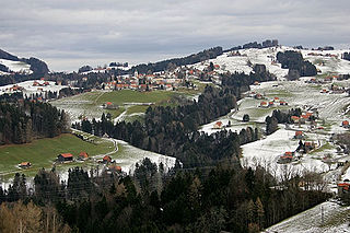
Wald is a municipality in the canton of Appenzell Ausserrhoden in Switzerland.

<span class="mw-page-title-main">Küssnacht</span> Municipality in Schwyz canton, Switzerland

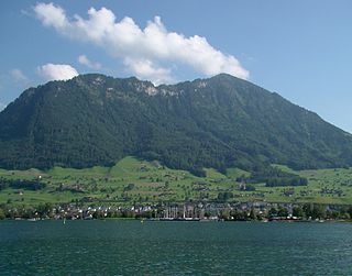
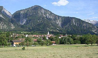
Küssnacht am Rigi is a village and a district and a municipality in the canton of Schwyz in Switzerland. The municipality consists of three villages Küssnacht, Immensee, and Merlischachen, the hamlet Haltikon, the industrial area Fänn, and the alp Seeboden. It is situated at the north shore of Lake Lucerne and at the south shore of Lake Zug below mount Rigi.

<span class="mw-page-title-main">Sils im Engadin/Segl</span> Municipality in Graubünden, Switzerland

Sils im Engadin/Segl, often also as Sils i.E./Segl, is a municipality and village in the Maloja Region, Upper Engadine in the Swiss canton of the Grisons.

<span class="mw-page-title-main">Madulain</span> Municipality in Graubünden, Switzerland

Madulain is a municipality in the Maloja Region in the Swiss canton of Graubünden.

<span class="mw-page-title-main">Falera</span> Municipality in Graubünden, Switzerland

Falera is a municipality in the Surselva Region in the Swiss canton of Graubünden.

<span class="mw-page-title-main">Churwalden</span> Municipality in Graubünden, Switzerland

Churwalden is a municipality in the Plessur Region in the canton of Graubünden in Switzerland. It incorporates the former municipalities of Malix and Parpan.

<span class="mw-page-title-main">Seedorf, Uri</span> Municipality in Uri, Switzerland

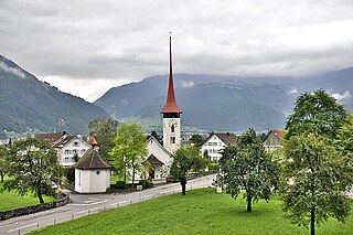
Seedorf is a municipality in the canton of Uri in Switzerland. On 1 January 2021 the former municipality of Bauen merged into the municipality of Seedorf.

<span class="mw-page-title-main">Maladers</span> Former municipality in Graubünden, Switzerland

Maladers is a former municipality in the Plessur Region in the canton of Graubünden in Switzerland. On 1 January 2020 the former municipality of Maladers merged into Chur.

<span class="mw-page-title-main">Fideris</span> Municipality in Graubünden, Switzerland

Fideris(Romansh: Fadrein) is a Swiss village in the Prättigau and a municipality in the political district Prättigau/Davos Region in the canton of Graubünden.

<span class="mw-page-title-main">Zizers</span> Municipality in Graubünden, Switzerland

Zizers is a municipality in the Landquart Region in the Swiss canton of Graubünden. Zita of Bourbon-Parma, Empress of Austria-Hungary died in Zizers.

<span class="mw-page-title-main">Sils im Domleschg</span> Municipality in Graubünden, Switzerland

Sils im Domleschg is a municipality in the Viamala Region in the Swiss canton of Graubünden.

<span class="mw-page-title-main">Val Terbi</span> Municipality in Jura, Switzerland

Val Terbi is a municipality in the district of Delémont in the canton of Jura in Switzerland. The municipalities of Montsevelier, Vermes and Vicques merged on 1 January 2013 into the new municipality of Val Terbi. On 1 January 2018 the former municipality of Corban merged into the municipality of Val Terbi.

<span class="mw-page-title-main">Val-de-Charmey</span> Municipality in Fribourg, Switzerland

Val-de-Charmey is a municipality in the district of Gruyère in the canton of Fribourg in Switzerland. On 1 January 2014 the former municipalities of Cerniat and Charmey merged into the municipality of Val-de-Charmey.

<span class="mw-page-title-main">Obersaxen Mundaun</span> Municipality in Graubünden, Switzerland

Obersaxen Mundaun is a municipality in the Surselva Region in the Swiss canton of Graubünden. On 1 January 2016 the former municipalities of Obersaxen and Mundaun merged to form the new municipality of Obersaxen Mundaun.

<span class="mw-page-title-main">Cheyres-Châbles</span> Municipality in Fribourg, Switzerland

Cheyres-Châbles is a municipality in the district of Broye in the canton of Fribourg in Switzerland. On 1 January 2017 the former municipalities of Châbles and Cheyres merged into the new municipality of Cheyres-Châbles.

There are 26 constituencies in Switzerland – one for each of the 26 cantons of Switzerland – for the election of the National Council and the Council of States.

References

  1. "Arealstatistik Standard - Gemeinden nach 4 Hauptbereichen". Federal Statistical Office. Retrieved 13 January 2019.
  2. "Ständige Wohnbevölkerung nach Staatsangehörigkeitskategorie Geschlecht und Gemeinde; Provisorische Jahresergebnisse; 2018". Federal Statistical Office. 9 April 2019. Retrieved 11 April 2019.
  3. Handbuch der historischen Stätten. Schweiz und Liechtenstein. pg. 452, Article Oberegg(in German)
  4. Arealstatistik Standard - Gemeindedaten nach 4 Hauptbereichen
  5. "Arealstatistik Land Use - Gemeinden nach 10 Klassen". www.landuse-stat.admin.ch. Swiss Federal Statistical Office. 24 November 2016. Retrieved 27 December 2016.
  6. 1 2 3 4 5 Swiss Federal Statistical Office - Regional portraits accessed 27 October 2016
  7. "Ständige und nichtständige Wohnbevölkerung nach institutionellen Gliederungen, Geburtsort und Staatsangehörigkeit". bfs.admin.ch (in German). Swiss Federal Statistical Office - STAT-TAB. 31 December 2020. Retrieved 21 September 2021.
  8. Federal Statistical Office - Ständige und nichtständige Wohnbevölkerung nach institutionellen Gliederungen, Geburtsort und Staatsangehörigkeit (Land) accessed 31 October 2016
  9. 1 2 3 Swiss Federal Statistical Office accessed 16-Sep-2009
  10. Swiss Federal Statistical Office - Ständige und nichtständige Wohnbevölkerung nach institutionellen Gliederungen, Geschlecht, Zivilstand und Geburtsort (in German) accessed 8 September 2016
  11. Swiss Federal Statistical Office STAT-TAB - Thema 09 - Bau- und Wohnungswesen (in German) accessed 5 May 2016
  12. Swiss Federal Statistical Office STAT-TAB Bevölkerungsentwicklung nach institutionellen Gliederungen, 1850-2000 (in German) accessed 27 April 2016
  13. Swiss Federal Statistical Office - Nationalratswahlen 2015: Stärke der Parteien und Wahlbeteiligung nach Gemeinden Archived 2016-08-02 at the Wayback Machine (in German) accessed 18 July 2016
  14. "Die Raumgliederungen der Schweiz 2016" (in German, French, Italian, and English). Neuchâtel, Switzerland: Swiss Federal Statistical Office. 17 February 2016. Retrieved 14 December 2016.
  15. Federal Statistical Office -Arbeitsstätten und Beschäftigte nach Gemeinde, Wirtschaftssektor und Grössenklasse accessed 31 October 2016