The first mentioning of Trogen was in 1168 (Trugin). The name Trogen refers to a number of fountains (Trögen) which is reflected in the coat of arms.
After the Appenzell Wars, the Rhode Trogen was created in 1429 which included the territories of the municipalities Oberegg as well as parts of Bühler and Gais. Trogen joined the Reformation in 1525. When Appenzell split into the half-cantons Appenzell Innerrhoden and Appenzell Ausserrhoden in 1597, it became the administrative center of Appenzell Ausserrhoden. From then on, Trogen's territory progressively shrunk as different municipalities within built their own churches within the Rhode and thus became independent. Until 1658, the municipalities of Grub, Walzenhausen, Heiden, Wolfhalden and Lutzenberg had emerged from Trogen.[3]
From the 16th century until the Industrial Revolution, Trogen accumulated most of its wealth through the sales of weaved and embroidered fabrics. This enrichment was driven mainly by the trade of canvases by the Zellweger-family. The Zellweger trading house was founded in the 17th century by the father of the family Conrad Zellweger-Rechsteiner and his son Conrad Zellweger-Tanner. The so-called Zellweger-Paläste (Zellweger-palaces), which are built around the town center, Landsgemeindeplatz, of Trogen, were built by the different members and generations of the family. The buildings led to inner tensions within the Zellweger-family and partial dissolutions of business alliances, as every new building was meant to outdo the previous palaces. The last Zellweger-owned business went bankrupt in 1817, and since 1866, the Landsgemeindeplatz has remained unmodified. A renovation of the town center and the palaces was voted for in 2011 and executed from 2019 to 2021.[3] The grammar school (Kantonsschule) that is today the only grammar school in the canton was also founded by the family in 1821.[4]
In the beginning of the 20th century, Trogen's main source of income was the textile industry, as 66% of its inhabitants were active in this sector. At the same time, the village began to expand its sources of income by slowly developing its health and ski resort infrastructure, which also led to the foundation of the Strassenbahn St. Gallen–Speicher–Trogen in 1900 and the inauguration of the Trogenerbahn three years later.[5] During the interwar period from 1918 to 1939, Trogen's number of inhabitants sank drastically. Although the economy recovered thereafter, the maximum value of inhabitants of 1850 (cf. Demographics) was since then never surpassed.[6]
Trogen has been the home of the Kinderdorf Pestalozzi since 1946. Further, Trogen has been an Energiestadt since 2014.The label attests that the municipality is making particular efforts in climate protection such as more ecological transportation, investments in renewable energy sources and more efficient usage of energy.[7]
Geography
Aerial view (1949)Countryside above Trogen with the Appenzell Alps in background
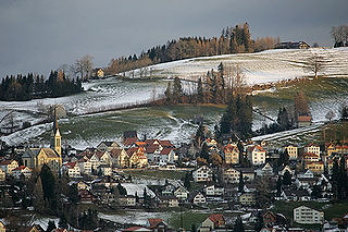
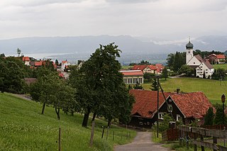
Trogen has an area, as of 2023, of 10.03km2 (3.87sqmi). Of this area, 49.2% is used for agricultural purposes, while 41.4% is forested. Of the rest of the land, 8.6% is settled (buildings or roads) and the remainder (0.8%) is non-productive (rivers, glaciers or mountains).[8] Trogen is dominated by the local mountain Gäbris.
Demographics
Trogen has a population (as of 2008[update]) of 1,688, of which about 7.7% are foreign nationals.[9] Over the last 10 years the population has decreased at a rate of -15.2%. Most of the population (as of 2000[update]) speaks German (92.9%), with Serbo-Croatian being second most common ( 2.0%) and Italian being third ( 0.9%).[10]As of 2000[update], the gender distribution of the population was 50.3% male and 49.7% female.[11] The age distribution, as of 2000[update], in Trogen is; 130 people or 7.0% of the population are between 0–6 years old. 271 people or 14.5% are 6–15, and 149 people or 8.0% are 16–19. Of the adult population, 80 people or 4.3% of the population are between 20 and 24 years old. 502 people or 26.9% are 25–44, and 452 people or 24.2% are 45–64. The senior population distribution is 186 people or 10.0% of the population are between 65 and 79 years old, and 97 people or 5.2% are over 80.[11]
In Trogen about 74.8% of the population (between age 25–64) have completed either non-mandatory upper secondary education or additional higher education (either university or a Fachhochschule).[10]
Trogen has an unemployment rate of 1.46%. As of 2005[update], there were 62 people employed in the primary economic sector and about 34 businesses involved in this sector. 76 people are employed in the secondary sector and there are 20 businesses in this sector. 751 people are employed in the tertiary sector, with 86 businesses in this sector.[10]
The historical population is given in the following table:
Several buildings in the village core, the Protestant church of 1782, the refectory with the cantonal library, the 1805 town hall and the two Zellweger palaces (Doppelpalast / Fünfeckpalast) are listed as heritage sites of national significance.[14]
Weather
Trogen has an average of 155.1 days of rain per year and on average receives 1,644mm (64.7in) of precipitation. The wettest month is July during which time Trogen receives an average of 209mm (8.2in) of precipitation. During this month there is precipitation for an average of 14.2 days. The month with the most days of precipitation is June, with an average of 15.4, but with only 203mm (8.0in) of precipitation. The driest month of the year is January with an average of 86mm (3.4in) of precipitation over 14.2 days.[15]
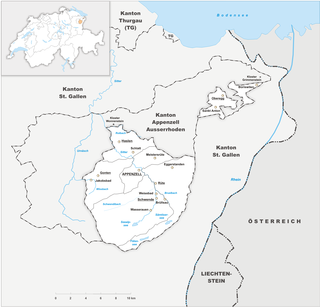
Appenzell Innerrhoden, in English sometimes Appenzell Inner-Rhodes, is one of the 26 cantons forming the Swiss Confederation. It is composed of six districts. The seat of the government and parliament is Appenzell. It is traditionally considered a "half-canton", the other half being Appenzell Ausserrhoden.
Appenzell Ausserrhoden, in English sometimes Appenzell Outer Rhodes, is one of the 26 cantons forming the Swiss Confederation. It is composed of twenty municipalities. The seat of the government and parliament is Herisau, and the seat of judicial authorities are in Trogen. It is traditionally considered a "half-canton", the other half being Appenzell Innerrhoden.
Urnäsch is a municipality in the canton of Appenzell Ausserrhoden, Switzerland.
Herisau is a municipality and the capital of the canton of Appenzell Ausserrhoden in Switzerland. It is the seat of the canton's government and parliament; the judicial authorities are situated in Trogen.
Stein is a municipality in the canton of Appenzell Ausserrhoden in Switzerland.
Teufen is a municipality in the canton of Appenzell Ausserrhoden in Switzerland.
Bühler is a municipality in the canton of Appenzell Ausserrhoden in Switzerland.
Speicher is a municipality in the canton of Appenzell Ausserrhoden, in Switzerland.
Rehetobel is a municipality in the canton of Appenzell Ausserrhoden in Switzerland.
Wolfhalden is a municipality in the canton of Appenzell Ausserrhoden in Switzerland.
Walzenhausen is a municipality in the canton of Appenzell Ausserrhoden in Switzerland.
The canton of St. Gallen or St Gall is a canton of Switzerland. Its capital is St. Gallen.
Appenzell was a canton in the northeast of Switzerland, and entirely surrounded by the canton of St. Gallen, in existence from 1403 to 1597.
Appenzell District is a district of the canton of Appenzell Innerrhoden in Switzerland. It has a population of 5,793. The area of Appenzell is 16.88 km2 (7 sq mi). The district of Appenzell consists of a part of the village Appenzell, as well as Rinkenbach, Kau and Meistersrüte.
Eggersriet is a municipality in the Wahlkreis (constituency) of St. Gallen in the canton of St. Gallen in Switzerland.
Appenzell Railways is a Swiss railway company with headquarters in Herisau. It operates a network of railways in the cantons of Appenzell Innerrhoden, Appenzell Ausserrhoden, St. Gallen and Thurgau.
The St. Gallen–Trogen railway, or Trogenerbahn (TB), is a 9.8 kilometres (6.1 mi) long railway line in Switzerland. It links the city of St. Gallen, in the canton of St. Gallen, with Speicher and Trogen, both in the canton of Appenzell Ausserrhoden. Passenger service on the line now forms part of the St. Gallen S-Bahn, branded as the S21.
The Appenzell–St. Gallen–Trogen railway, also known as the Durchmesserlinie, is a metre gauge overland tramway in the Swiss cantons of Appenzell Innerrhoden and Ausserrhoden and the city of St. Gallen. It is the steepest adhesion railway in Switzerland with a gradient of up to 8.0% and forms part of the network of the Appenzell Railways (AB) and the St. Gallen S-Bahn. The line's two branches were completed in sections between 1889 and 1904 by the St. Gallen-Gais-Appenzell-Altstätten Railway and the Trogen Railway. The two lines were connected by the AB with a cross-city route in 2018.
Gais railway station is a railway station in the municipality of Gais, in the Swiss canton of Appenzell Ausserrhoden. It is located at the junction of the 1,000 mmmetre gauge Appenzell–St. Gallen–Trogen and Altstätten–Gais lines of Appenzell Railways.
Speicher railway station is a railway station in Speicher, in the Swiss canton of Appenzell Ausserrhoden. It is a station on the 1,000 mm metre gauge St. Gallen–Trogen railway line of Appenzell Railways.
This page is based on this Wikipedia article Text is available under the CC BY-SA 4.0 license; additional terms may apply. Images, videos and audio are available under their respective licenses.