Related Research Articles

This is a list of structures, sites, districts, and objects on the National Register of Historic Places in North Carolina:

Stagville Plantation is located in Durham County, North Carolina. With buildings constructed from the late 18th century to the mid-19th century, Stagville was part of one of the largest plantation complexes in the American South. The entire complex was owned by the Bennehan, Mantack and Cameron families; it comprised roughly 30,000 acres (120 km2) and was home to almost 900 enslaved African Americans in 1860.

This is a list of the National Register of Historic Places listings in Lancaster County, Pennsylvania.

Nikwasi comes from the Cherokee word for "star", Noquisi (No-kwee-shee), and is the site of the Cherokee town which is first found in colonial records in the early 18th century, but is much older. The town covered about 100 acres (40 ha) on the floodplain of the Little Tennessee River. Franklin, North Carolina, was later developed by European Americans around this site.
The Hoojah Branch Site (9RA34) is an archaeological site in Rabun County, Georgia that had periods of occupation from the Archaic period to the Mississippian period. It is believed to be a platform mound similar to others across North Georgia built by peoples of the South Appalachian Mississippian culture that flourished in the Southeastern United States from approximately the years 1000 to 1600. The site is located about one mile east of Dillard, Georgia and is in the Chattahoochee National Forest and may have had a connection to the Qualla mound complexes in southwestern North Carolina. The site was listed on the National Register of Historic Places on January 24, 1973 as reference number 86003667

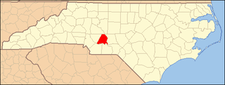
Town Creek Indian Mound is a prehistoric Native American archaeological site located near present-day Mount Gilead, Montgomery County, North Carolina, in the United States. The site, whose main features are a platform mound with a surrounding village and wooden defensive palisade, was built by the Pee Dee, a South Appalachian Mississippian culture people that developed in the region as early as 980 CE. They thrived in the Pee Dee River region of North and South Carolina during the Pre-Columbian era. The Town Creek site was an important ceremonial site occupied from about 1150—1400 CE. It was abandoned for unknown reasons. It is the only ceremonial mound and village center of the Pee Dee located within North Carolina.

This list includes properties and districts listed on the National Register of Historic Places in Rockingham County, North Carolina. Click the "Map of all coordinates" link to the right to view an online map of all properties and districts with latitude and longitude coordinates in the table below.

This list includes properties and districts listed on the National Register of Historic Places in Macon County, North Carolina. Click the "Map of all coordinates" link to the right to view a Google map of all properties and districts with latitude and longitude coordinates in the table below.
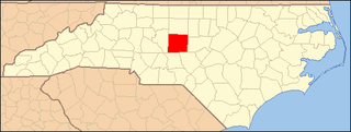
This list includes properties and districts listed on the National Register of Historic Places in Randolph County, North Carolina. Click the "Map of all coordinates" link to the right to view a Google map of all properties and districts with latitude and longitude coordinates in the table below.
This list includes properties and districts listed on the National Register of Historic Places in Stanly County, North Carolina. Click the "Map of all coordinates" link to the right to view an online map of all properties and districts with latitude and longitude coordinates in the table below.

This list includes properties and districts listed on the National Register of Historic Places in Swain County, North Carolina. Click the "Map of all coordinates" link to the right to view an online map of all properties and districts with latitude and longitude coordinates in the table below.

This list includes properties and districts listed on the National Register of Historic Places in Yadkin County, North Carolina. Click the "Map of all coordinates" link to the right to view a Google map of all properties and districts with latitude and longitude coordinates in the table below.

This list includes properties and districts listed on the National Register of Historic Places in Montgomery County, North Carolina. Click the "Map of all coordinates" link to the right to view an online map of all properties and districts with latitude and longitude coordinates in the table below.

Judaculla Rock is a curvilinear-shaped outcrop of soapstone known for its ancient carvings and petroglyphs. The archaeological site is located on a 0.85-acre rectangular-shaped property, now owned by Jackson County. It is approximately 60 meters east of Caney Fork Creek, a major branch of the northwestward-trending Tuckasegee River in the mountains of Western North Carolina.

The Wilson Mounds and Village Site is a prehistoric archaeological site located in and around the Marshall Ferry Cemetery in Rising Sun, White County, Illinois. The site includes twelve Hopewell burial mounds and a village site.

The Hidden Valley Rockshelter (44-BA-31) is a significant archaeological site located near the community of Warm Springs in Bath County, Virginia, United States. A large rockshelter located near the Jackson River, it has been occupied by humans for thousands of years, and it has been named a historic site.

Too-Cowee, was an important historic Cherokee town located near the Little Tennessee River north of present-day Franklin, North Carolina. It also had a prehistoric platform mound and earlier village built by ancestral peoples. As their expression of public architecture, the Cherokee built a townhouse on top of the mound. It was the place for their community gatherings in their highly decentralized society. The name translates to "pig fat" in English. British traders and colonists referred to Cowee as one of the Cherokee Middle Towns along this river; they defined geographic groupings based in relation to their coastal settlements, such as Charlestown, South Carolina.
Nununyi was a historic village of the Cherokee people in western North Carolina, located on the eastern side of the Oconaluftee River. Today it is within the boundaries of the present-day city of Cherokee in Swain County. It was classified by English traders and colonists as among the "Out Towns" of the Cherokee in this area east of the Appalachian Mountains.
Donnaha Site is a historic archaeological site located on the banks of the Yadkin River near East Bend, Yadkin County, North Carolina. The site includes well-preserved organic remains from a village occupied between ca. A.D. 1000 and A.D. 1500.
The Thayer Farm Site, designated by the Smithsonian trinomial 31RD10, is a prehistoric archaeological site in Randolph County, North Carolina. The site, long known to local collectors for surface level finds, was formally investigated in 1984, and was found to consist of a stratified series of deposits bearing evidence of occupation between about 1200 and 1700 AD. Finds at the site include pottery fragments, projectile points, animal bone, shell fragments, and human bone, the latter indicating the presence of burials. Two acres of the site were donated to the Historic Preservation Foundation for North Carolina in 1985.
References
- 1 2 "National Register Information System". National Register of Historic Places . National Park Service. July 9, 2010.
- ↑ "Rhodes Site". North Carolina Office of Archaeology. Retrieved September 14, 2014.
