
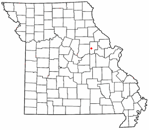
Rich Fountain is an unincorporated community in Osage County, Missouri, United States. [1] It is located approximately three miles east of U.S. Route 63 and is fifteen miles southeast of Jefferson City.
Rich Fountain is an unincorporated community in Osage County, Missouri, United States. [1] It is located approximately three miles east of U.S. Route 63 and is fifteen miles southeast of Jefferson City.
Rich Fountain had its start circa 1839, when John Strumpf built a gristmill there. [2] The community was named for a spring near the original town site. [3] A post office called Rich Fountain was established in 1854, and remained in operation until 1972. [4]
The Sacred Heart Catholic Church and Parsonage was listed on the National Register of Historic Places in 1982. [5]

Osage County is a county in the central part of the U.S. state of Missouri. As of the 2020 census, the population was 13,274. Its county seat is Linn. The county was organized January 29, 1841, and named from the Osage River.

Chamois is a city in Osage County, Missouri, United States. The population was 377 at the 2020 census. It is part of the Jefferson City, Missouri Metropolitan Statistical Area.

Linn is a city in Osage County, Missouri, United States. The population was 1,350 at the 2020 census. It is the county seat of Osage County. Linn is part of the Jefferson City, Missouri Metropolitan Statistical Area.
Mineola is an unincorporated community in western Montgomery County, Missouri, United States. The community is located on Missouri Supplemental Route J and is about one mile south from Interstate 70. Montgomery City is approximately six miles north of the community. It is on the east bank of the Loutre River. Graham Cave within Graham Cave State Park is on the north side of I-70 just north of the community and Mount Horeb Baptist Church is approximately 4.5 miles to the southwest.

Bonnots Mill is an unincorporated community in northern Osage County, Missouri, United States. It is located approximately ten miles east of Jefferson City on the Osage River, near its confluence with the Missouri River. The community of Osage City is about four miles to the west-southwest on the Osage and the community of Tebbetts lies across the Missouri River valley to the north. It has also been known as Dauphine, Bonnets Mills, Bonnots, or Bonnotts Mill.
Frankenstein is an unincorporated community in northwestern Osage County, Missouri, United States. It is located approximately 20 km (12 mi) east of Jefferson City. Frankenstein is located on Missouri Route C, about midway between Luystown to the east and Bonnots Mill to the west. Cedar Creek flows past, about one mile south of the site.

Loose Creek is an unincorporated community in Osage County, Missouri, United States. It is located north of U.S. Route 50, approximately eight miles east of Missouri's capital of Jefferson City. The ZIP Code for Loose Creek is 65054.
Osage City is an unincorporated community in Cole County, in the U.S. state of Missouri.
Marys Home is an unincorporated community in northern Miller County, in the U.S. state of Missouri. The community is on Missouri Route H, approximately two miles north of the Osage River. The town of Eugene in the southwest corner of Cole County is about four miles to the northwest, by Route H and Missouri Route 17.
Brush Creek is a stream in Osage County in central Missouri. It is a tributary of the Gasconade River.
Byron is an unincorporated community in Osage County, in the U.S. state of Missouri.
Cooper Hill is an unincorporated community in Osage County, in the U.S. state of Missouri.
Crook is an unincorporated community in Osage County, in the U.S. state of Missouri.
Deer is an unincorporated community in Osage County, in the U.S. state of Missouri.
Dingley is an extinct town in Osage County, in the U.S. state of Missouri.
Freedom is an unincorporated community in Osage County, in the U.S. state of Missouri. The village lies on Missouri Route N, approximately one mile north of U.S. Route 50 and two miles north of the Gasconade River.
Hope is an unincorporated community in Osage County, in the U.S. state of Missouri.
Judge is an unincorporated community in Osage County, in the U.S. state of Missouri.
Luystown is an unincorporated community in Osage County, in the U.S. state of Missouri.
Swan Creek is a stream in Osage County in Missouri. It is a tributary of the Gasconade River.
Coordinates: 38°23′45″N91°52′48″W / 38.39583°N 91.88000°W
Municipalities and communities of Osage County, Missouri, United States | ||
|---|---|---|
| Cities |  | |
| Villages | ||
| Townships | ||
| Unincorporated communities | ||
| Ghost towns | ||
| Footnotes | ‡This populated place also has portions in an adjacent county or counties | |
| | This Osage County, Missouri state location article is a stub. You can help Wikipedia by expanding it. |