Aud, Missouri | |
|---|---|
 Aud, Missouri  Aud, Missouri | |
| Coordinates: 38°34′49″N91°43′15″W / 38.58028°N 91.72083°W | |
| Country | United States |
| State | Missouri |
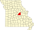
| County | Osage |
| Elevation | 656 ft (200 m) |
| Time zone | UTC-6 (Central (CST)) |
| • Summer (DST) | UTC-5 (CDT) |
| ZIP Code | 65024 |
| Area code | 573 |
| GNIS feature ID | 740644 [1] |
Aud is an unincorporated community in Osage County, in the U.S. state of Missouri. [1]