Richwood, Louisiana

Last updated

Richwood, Louisiana
Town
Town of Richwood
Ouachita Parish Louisiana Incorporated and Unincorporated areas Richwood Highlighted.svg
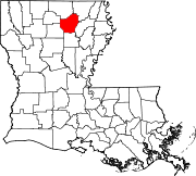
Location of Richwood in Ouachita Parish, Louisiana.
Louisiana in United States (US48).svg
Location of Louisiana in the United States
Coordinates: 32°27′35″N92°04′31″W / 32.45972°N 92.07528°W / 32.45972; -92.07528
CountryUnited States
StateLouisiana
Parish Ouachita
Government
  MayorGerald Brown, Sr. (D)
Area
[1]
  Total
2.52 sq mi (6.52 km2)
  Land2.52 sq mi (6.52 km2)
  Water0.00 sq mi (0.00 km2)
Elevation
69 ft (21 m)
Population
 (2020)
  Total
3,881
  Density1,542.53/sq mi (595.66/km2)
Time zone UTC-6 (CST)
  Summer (DST) UTC-5 (CDT)
ZIP code
71202 [2]
Area code 318
FIPS code 22-64660
Website www.townofrichwood.com

Richwood is a town in Ouachita Parish, Louisiana, United States. The Town was incorporated December 31, 1974, under the provision of Louisiana Revised Statute 33:52. The Town operates under a form of government consisting of an elected mayor and a board of alder persons, which has five elected members. The Town provides garbage collection, street maintenance, drainage maintenance, and other health and welfare services, in addition to the administrative services provided to its residents. The population was 3,392 at the 2010 census.

Contents

Geography

Richwood is located in the southern portion of Ouachita Parish of Northeast Louisiana at 32°27′35″N92°4′31″W / 32.45972°N 92.07528°W / 32.45972; -92.07528 (32.459587, -92.075184). [3]

According to the United States Census Bureau, the town has a total area of 2.3 square miles (6.0 km2), all land.

Demographics

Historical population
CensusPop.Note
1980 1,223
1990 1,2532.5%
2000 2,11568.8%
2010 3,39260.4%
2020 3,88114.4%
U.S. Decennial Census [4]
Richwood racial composition [5]
RaceNumberPercentage
White (non-Hispanic)52213.45%
Black or African American (non-Hispanic)2,27858.7%
Native American 50.13%
Asian 2295.9%
Other/Mixed 601.55%
Hispanic or Latino 78720.28%

As of the 2020 United States census, there were 3,881 people, 607 households, and 348 families residing in the town.

Education

Ouachita Parish School System is the area school district. [6]

Most of Richwood is in the zone for Robinson Elementary School while small pieces are zoned to Swayze Elementary School. Both feed into Richwood Middle and Richwood High School. [7]

See also

Related Research Articles

<span class="mw-page-title-main">Union Parish, Louisiana</span> Parish in Louisiana, United States

Union Parish is a parish located in the north central section of the U.S. state of Louisiana. As of the 2020 census, the population was 21,107. The parish seat is Farmerville. The parish was created on March 13, 1839, from a section of Ouachita Parish. Its boundaries have changed four times since then.

<span class="mw-page-title-main">Ouachita Parish, Louisiana</span> Parish in Louisiana, United States

Ouachita Parish is a parish located in the northern part of the U.S. state of Louisiana. As of the 2020 census, the population was 160,368. The parish seat and largest city is Monroe. The parish was formed in 1807.

<span class="mw-page-title-main">Lincoln Parish, Louisiana</span> Parish in Louisiana, United States

Lincoln Parish is a parish located in the U.S. state of Louisiana. As of the 2020 census, the population was 48,396. The parish was created on February 24, 1873, from parts of Bienville, Claiborne, Union, and Jackson parishes, and its boundaries have changed only once. This makes Lincoln Parish one of the Reconstruction parishes.

<span class="mw-page-title-main">Benton, Louisiana</span> Town in Louisiana, United States

Benton is a town in, and the parish seat of, Bossier Parish, in the U.S. state of Louisiana. The population was 2,048 in 2020. The town is named for 19th century U.S. Senator Thomas Hart Benton, a Democrat from Missouri and an ally of U.S. President Andrew Jackson.

Eastwood is an unincorporated community and census-designated place (CDP) in Bossier Parish, Louisiana, United States. The population was 4,093 at the 2010 census. It is part of the Shreveport–Bossier City Metropolitan Statistical Area.

<span class="mw-page-title-main">Haughton, Louisiana</span> Town in Louisiana, United States

Haughton is a town in Bossier Parish, Louisiana, United States. The population was 4,539 in 2020. It is part of the Shreveport–Bossier City metropolitan statistical area.

<span class="mw-page-title-main">Shenandoah, Louisiana</span> Census-designated place in Louisiana, United States

Shenandoah is an unincorporated area and census-designated place (CDP) in East Baton Rouge Parish, Louisiana, United States. It is part of the Baton Rouge Metropolitan Statistical Area. The population was 18,399 at the 2010 census, up from 17,070 in 2000. Shenandoah consists of a number of residential subdivisions, including Shenandoah Estates, Shenandoah Park, White Oak Landing, White Oak Estates, The Woods and The Lake at White Oak.

<span class="mw-page-title-main">Village St. George, Louisiana</span> Census-designated place in Louisiana, United States

Village St. George is a census-designated place (CDP) in East Baton Rouge Parish, Louisiana, United States. The population was 7,104 at the 2010 census. It is part of the Baton Rouge Metropolitan Statistical Area.

Elmwood is a census-designated place (CDP) in Jefferson Parish, Louisiana, United States, within the New Orleans–Metairie–Kenner metropolitan statistical area. The population was 4,635 at the 2010 census, and 5,649 in 2020. Elmwood was part of neighboring Jefferson's census area from 1960 to 1990. The ZIP Code serving Elmwood is 70123.

Claiborne is an unincorporated community and census-designated place (CDP) in Ouachita Parish, Louisiana, United States. The population was 9,830 at the 2000 census. It is part of the Monroe Metropolitan Statistical Area.

<span class="mw-page-title-main">Monroe, Louisiana</span> City in Louisiana, United States

Monroe is the ninth-largest city in the U.S. state of Louisiana, and is the parish seat and largest city of Ouachita Parish. With a 2020 census-tabulated population of 47,702, it is the principal city of the Monroe metropolitan statistical area, the second-largest metropolitan area in North Louisiana.

<span class="mw-page-title-main">Sterlington, Louisiana</span> Town in Louisiana, United States

Sterlington is a town in northern Ouachita Parish, Louisiana, United States, near the boundary with Union Parish. At the 2010 census, the population was 1,594. In the 2018 census estimates, the population rose to 2,724. In 2014, Sterlington was the fastest-growing community in Northeast Louisiana.

<span class="mw-page-title-main">Swartz, Louisiana</span> Census-designated place in Louisiana, United States

Swartz is a census-designated place (CDP) in Ouachita Parish in northeastern Louisiana, United States. The population was 4,354 at the 2020 United States Census. It is part of the Monroe Metropolitan Statistical Area.

Reserve is an unincorporated community in St. John the Baptist Parish, Louisiana, United States. It is located on the east bank of the Mississippi River. The population was 9,111 at the 2000 census. For statistical purposes, the United States Census Bureau has defined Reserve as a census-designated place (CDP).

<span class="mw-page-title-main">Ouachita Parish School Board</span> School district in Louisiana, United States


Ouachita Parish School Board is a school district headquartered in West Monroe, Louisiana, United States.

<span class="mw-page-title-main">Calhoun, Louisiana</span> Census-designated place in Louisiana, United States

Calhoun is an unincorporated community and census-designated place in Ouachita Parish, Louisiana, United States. It is named after Archibald Calhoun, who was an original settler and landowner. Its elevation is 177 feet (54 m), and it is located at 32°30′46″N92°21′31″W. Calhoun is unincorporated and is governed by the parish through a board of commissioners known as the Police Jury. It is a census designated place and at the time of the most recent United States Census Survey, the population was 1,965.

Lakeshore is an unincorporated community and census-designated place in Ouachita Parish, Louisiana, United States. Its population was 1,930 as of the 2010 census. The community is located on the south bank of Bayou Desiard, east of Monroe.

Bawcomville is an unincorporated community and census-designated place in Ouachita Parish, Louisiana, United States. Its population was 3,588 as of the 2010 census.

Brownsville is an unincorporated community and census-designated place in Ouachita Parish, Louisiana, United States. Its population was 4,317 as of the 2010 census.

Lockport Heights is an unincorporated community and census-designated place in Lafourche Parish, Louisiana, United States. Its population was 1,286 as of the 2010 census. Louisiana Highway 1 passes through the community.

References

  1. "2020 U.S. Gazetteer Files". United States Census Bureau. Retrieved March 20, 2022.
  2. "Richwood LA ZIP Code". zipdatamaps.com. 2023. Retrieved June 16, 2023.
  3. "US Gazetteer files: 2010, 2000, and 1990". United States Census Bureau. February 12, 2011. Retrieved April 23, 2011.
  4. "Census of Population and Housing". Census.gov. Retrieved June 4, 2015.
  5. "Explore Census Data". data.census.gov. Retrieved December 29, 2021.
  6. "2020 CENSUS - SCHOOL DISTRICT REFERENCE MAP: Ouachita Parish, LA" (PDF). U.S. Census Bureau. pp. 19-20 (PDF pp. 20-21/31). Retrieved January 4, 2025. - Text list
  7. "Feeder Schools Correlation" (PDF). Ouachita Parish School Board . Retrieved January 4, 2024. - Linked from here. Robinson ES boundary map, Swayze ES boundary map.