A ZIP Code is a postal code used by the United States Postal Service (USPS) in a system it introduced in 1963. The term ZIP is an acronym for Zone Improvement Plan; it was chosen to suggest that the mail travels more efficiently and quickly when senders use the code in the postal address. The basic format consists of five digits. An extended ZIP+4 code was introduced in 1983 which includes the five digits of the ZIP Code, followed by a hyphen and four additional digits that reference a more specific location.
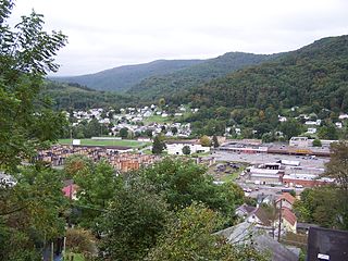
Richwood is a city in Nicholas County, West Virginia, United States. In 2010, the census showed Richwood with a population of 2,051. During the 19th and early 20th century Richwood was a booming coal and lumber town. Richwood has a very rich history, including the formation of the Cherry River Navy civic organization to draw attention to issues important to the community. Richwood has also became known statewide as the "Ramp Capital of the World". Each year, in April, the city hosts a large festival that draws visitors from around the country.
POSTNET is a barcode symbology used by the United States Postal Service to assist in directing mail. The ZIP Code or ZIP+4 code is encoded in half- and full-height bars. Most often, the delivery point is added, usually being the last two digits of the address or PO box number.
ZIP Code Tabulation Areas (ZCTAs) are statistical entities developed by the United States Census Bureau for tabulating summary statistics. These were introduced with the Census 2000 and continued with the 2010 Census. This new entity was developed to overcome the difficulties in precisely defining the land area covered by each ZIP code. Defining the extent of an area is necessary in order to tabulate census data for that area.
Richwoods is an unincorporated community in northern Washington County, Missouri, United States founded in 1830. It is located just off Route 47 about 15 miles west of De Soto and 19 miles south of St. Clair.

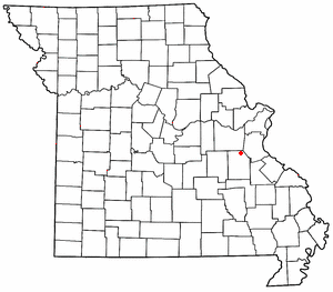
Claibourne Township is one of the fourteen townships of Union County, Ohio, United States. The 2010 census found 3,519 people in the township, 2,229 of whom lived in the village of Richwood.

Leivasy is an unincorporated community in Nicholas County, West Virginia, United States. Leivasy is located on West Virginia Route 20 9.5 miles (15.3 km) of Richwood. Leivasy has a post office with ZIP code 26676.

Arcola is an unincorporated community in Upper Providence Township, Montgomery County, Pennsylvania, United States. Arcola is located on Perkiomen Creek 6.5 miles (10.5 km) west-northwest of Norristown. Arcola has a post office with ZIP code 19420, which opened on June 4, 1889.

Richwood is an unincorporated community and census-designated place (CDP) located in Gloucester County, New Jersey, United States, that is split between Harrison Township and Mantua Township. As of the 2010 United States Census, the CDP's total population was 3,459.

Allaire is an unincorporated community located within Wall Township in Monmouth County, New Jersey, United States. As of the 2010 United States Census, the ZIP Code Tabulation Area for ZIP Code 07727 had a population of 7,050.
Ewan is an unincorporated community located within Harrison Township, in Gloucester County, New Jersey, United States. The area is served by the United States Postal Service as ZIP code 08025.
Rillton is an unincorporated community in Westmoreland County, Pennsylvania, United States. The community is 2.9 miles (4.7 km) southwest of Irwin. Rillton has a post office with ZIP code 15678.
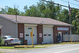
Bunola is an unincorporated community in Allegheny County, Pennsylvania, United States. The community is located along the Monongahela River 14.2 miles (22.9 km) south of Pittsburgh. Bunola has a post office with ZIP code 15020, which opened on May 26, 1888. They had a Volunteer Fire Department up until January of 2018, Such services have been taken over by the Elizabeth Borough Volunteer Fire Department. Elizabeth, Pennsylvania. [4]
Jacobs Creek is an unincorporated community in Westmoreland County, Pennsylvania, United States. The community is located at the mouth of Jacobs Creek on the Youghiogheny River, 1.5 miles (2.4 km) south of Smithton. Jacobs Creek has a post office with ZIP code 15448, which opened on December 14, 1865.
Uledi is an unincorporated community in Fayette County, Pennsylvania, United States. The community is located along Pennsylvania Route 21 4 miles (6.4 km) west of Uniontown. Uledi has a post office with ZIP code 15484, which opened on April 14, 1902.
Jones Mills is an unincorporated community in Westmoreland County, Pennsylvania, United States. The community is located along Pennsylvania Routes 31 and 381 2.8 miles (4.5 km) east-southeast of Donegal. Jones Mills has a post office with ZIP code 15646, which opened on May 23, 1850.
Spring Church is an unincorporated community in Armstrong County, Pennsylvania, United States. The community is located along Pennsylvania Route 56 4.4 miles (7.1 km) east-northeast of Apollo. Spring Church has a post office with ZIP code 15686.
Wood is an unincorporated community in the U.S. state of Pennsylvania; portions of the community lie in Bedford, Fulton, and Hundington counties. The community is 2.4 miles (3.9 km) south of Broad Top City. Wood has a post office with ZIP code 16694, which opened on September 9, 1908.

Mount Marion is a hamlet in Ulster County, New York, United States. The community is 3.2 miles (5.1 km) south-southwest of Saugerties. Mount Marion has a post office with ZIP code 12456.
Wales Center is a hamlet in Erie County, New York, United States. The community is located along U.S. Route 20A 4.2 miles (6.8 km) east of East Aurora. Wales Center has a post office with ZIP code 14169, which opened on November 9, 1842.


