
U.S. Route 101, or U.S. Highway 101 (US 101), is a north–south United States Numbered Highway that traverses the states of California, Oregon, and Washington, on the West Coast of the United States. It travels for over 1,500 miles (2,400 km), primarily along the Pacific Ocean, and is also known by various names, including El Camino Real in parts of California, the Oregon Coast Highway, and the Olympic Highway in Washington. Despite its three-digit number, normally used for spur routes, US 101 is classified as a major route in the United States Numbered Highway System.

State Route 1 (SR 1) is a major north–south state highway that runs along most of the Pacific coastline of the U.S. state of California. At 656 miles (1,056 km), it is the longest state route in California, and the second-longest in the US after Montana Highway 200. SR 1 has several portions designated as either Pacific Coast Highway (PCH), Cabrillo Highway, Shoreline Highway, or Coast Highway. Its southern terminus is at Interstate 5 (I-5) near Dana Point in Orange County and its northern terminus is at U.S. Route 101 (US 101) near Leggett in Mendocino County. SR 1 also at times runs concurrently with US 101, most notably through a 54-mile (87 km) stretch in Ventura and Santa Barbara counties, and across the Golden Gate Bridge.

Ventura, officially named San Buenaventura, is a city in and the county seat of Ventura County, California, United States. It is a coastal city located northwest of Los Angeles. The population was 110,763 at the 2020 census. Ventura is a popular tourist destination, owing to its historic landmarks, beaches, and resorts.

The Central Coast is an area of California, roughly spanning the coastal region between Point Mugu and Monterey Bay. It lies northwest of Los Angeles and south of the San Francisco Bay Area, and includes the rugged, rural, and sparsely populated stretch of coastline known as Big Sur.
Rincon(Spanish, "angle" or "corner") is a surf spot located at the Ventura and Santa Barbara County line in Southern California, United States. Also known as the "Queen of the Coast", Rincon is one of the most famous surf spots in California, known around the world for its well-formed waves and long rides. The book 100 Best Surf Spots in the World rates Rincon at 24. It is best at low tide during the winter months when swells are coming mostly from the west and northwest. There is a gated residential community that occupies most of the Rincon beachfront. Public access is provided at parking lots on both sides of the gated community, with restrooms and a picnic area in the upper parking lot, Rincon Beach Park.

The Southern California freeways are a vast network of interconnected freeways in the megaregion of Southern California, serving a population of 23 million people. The Master Plan of Metropolitan Los Angeles Freeways was adopted by the Regional Planning Commission in 1947 and construction began in the early 1950s. The plan hit opposition and funding limitations in the 1970s, and by 2004, only some 61% of the original planned network had been completed.

The Santa Susana Pass, originally Simi Pass, is a low mountain pass in the Simi Hills of Southern California, connecting the San Fernando Valley and Los Angeles neighborhood of Chatsworth, to the city of Simi Valley and eponymous valley.
La Conchita is a small unincorporated community in western Ventura County, California, on U.S. Route 101 just southeast of the Santa Barbara county line. The ZIP Code is 93001, and the community is inside area code 805.
State Route 150 is a state highway in the U.S. state of California. It runs from U.S. Route 101 near the Ventura/Santa Barbara County line to State Route 126 in Santa Paula, providing a connection to Lake Casitas and Ojai. It is a two-lane road. There were some one-lane bridges near the western end of the route, but these were rebuilt to be two-lane bridges after flooding in 2005.

State Route 192 is a state highway in the U.S. state of California. The route runs from State Route 154 near Santa Barbara to State Route 150 near the Santa Barbara–Ventura county line. The two-lane road is better known as Foothill Road, as the route runs parallel to the foothills of the Santa Ynez Mountains.
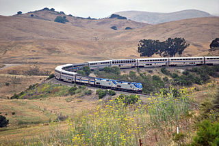
The Coast Line is a railroad line between Burbank, California and the San Francisco Bay Area, roughly along the Pacific Coast. It is the shortest rail route between Los Angeles and the Bay Area.

U.S. Route 101 (US 101) is a major north–south United States Numbered Highway, stretching from Los Angeles, California, to Tumwater, Washington. The California portion of US 101 is one of the last remaining and longest U.S. Routes still active in the state, and the longest highway of any kind in California. US 101 was also one of the original national routes established in 1926. Significant portions of US 101 between the Los Angeles area and the San Francisco Bay Area follow El Camino Real, the commemorative route connecting the former Alta California's 21 missions.
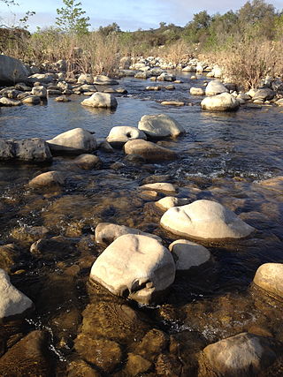
The Ventura River, in western Ventura County in southern California, United States, flows 16.2 miles (26.1 km) from its headwaters to the Pacific Ocean. The smallest of the three major rivers in Ventura County, it flows through the steeply sloped, narrow Ventura Valley, with its final 0.7 miles (1.1 km) through the broader Ventura River estuary, which extends from where it crosses under a 101 Freeway bridge through to the Pacific Ocean.

Ventura station is a passenger rail station in downtown Ventura, California. The station is served by Amtrak's Pacific Surfliner from San Luis Obispo to San Diego. Ten Pacific Surfliner trains serve the station daily. Of the 73 California stations served by Amtrak, Ventura was the 33rd-busiest in FY2010, boarding or detraining an average of approximately 125 passengers daily. The single platform is located on the south side of the tracks with a view of the Santa Barbara Channel and the Channel Islands. The Ventura Freeway is parallel with and on the north side of tracks.

Rincon Island is a small 2.3-acre artificial island located off Mussel Shoals in Ventura County, California on public land leased from the California State Lands Commission (CSLC). The island is situated approximately 3,000 feet (910 m) offshore in 55 feet (17 m) of water. The island was constructed in 1958 for the specific purpose of well drilling and oil and gas production. It is near the seaside communities of Mussel Shoals and La Conchita. The island is connected to the mainland by the Richfield Pier.

The Old Santa Susana Stage Road, or Santa Susana Wagon Road, is a route taken by early travelers between the San Fernando Valley and Simi Valley near Chatsworth, California, via the Santa Susana Pass. The main route climbs through what is now the Santa Susana Pass State Historic Park, with a branch in Chatsworth Park South.
Mussel Shoals is a coastal unincorporated community in Ventura County, California, between Ventura and the Santa Barbara County city of Carpinteria.
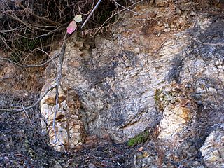
The Rincon Formation is a sedimentary geologic unit of Lower Miocene age, abundant in the coastal portions of southern Santa Barbara County, California eastward into Ventura County. Consisting of massive to poorly bedded shale, mudstone, and siltstone, it weathers readily to a rounded hilly topography with clayey, loamy soils in which landslides and slumps are frequent. It is recognizable on the south slopes of the Santa Ynez Mountains as the band at the base of the mountains which supports grasses rather than chaparral. Outcrops of the unit are infrequent, with the best exposures on the coastal bluffs near Naples, in the San Marcos Foothills, at the Tajiguas Landfill, and in road cuts. The geologic unit is notorious as a source of radon gas related to its high uranium content, released by radioactive decay.
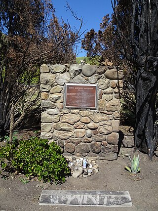
The Santa Gertrudis Asistencia, also known as the Santa Gertrudis Chapel, was an asistencia ("sub-mission") to the Mission San Buenaventura, part of the system of Spanish missions in Las Californias—Alta California. Built at an unknown date between 1792 and 1809, it was located approximately five miles from the main mission, inland and upstream along the Ventura River. The site was buried in 1968 by the construction of California State Route 33. Prior to the freeway's construction, archaeologists excavated and studied the site. A number of foundation stones were moved and used to create the Santa Gertrudis Asistencia Monument which was designated in 1970 as Ventura County Historic Landmark No. 11.

The Ventura River Parkway Trail is a southern California rail trail along the Ventura River in Ventura County. Roughly paralleling California State Route 33 for 16.5 mi (26.6 km) from Ventura to Ojai, it follows the route of the former Ventura and Ojai Valley Railroad that was abandoned between 1969 and 1995.
