
Holmfirth is a town in the Metropolitan Borough of Kirklees, West Yorkshire, England. It is located 6 miles (9.7 km) south of Huddersfield and 14 miles (23 km) west of Barnsley; the boundary of the Peak District National Park is 2 miles (3.2 km) to the south-west. The town is sited on the A635 and A6024 roads in the Holme Valley, at the confluence of the River Holme and Ribble. It mostly consists of stone-built cottages nestled on the eastern slopes of the Pennine hills.

Golcar is a village on a hillside crest above the Colne Valley in the Metropolitan Borough of Kirklees in West Yorkshire, England, 3 miles (5 km) west of Huddersfield, and just north of the River Colne and the Huddersfield Narrow Canal.

Mirfield is a town and civil parish in the Metropolitan Borough of Kirklees, West Yorkshire, England. Historically part of the West Riding of Yorkshire, it is on the A644 road between Brighouse and Dewsbury. At the 2011 census it had a population of 19,563. Mirfield forms part of the Heavy Woollen District.

Cleckheaton is a town in the Metropolitan Borough of Kirklees, West Yorkshire, England. Historically part of the West Riding of Yorkshire, it is situated south of Bradford, east of Brighouse, west of Batley and south-west of Leeds. It is at the centre of the Spen Valley and was the major town in the former borough of Spenborough. Cleckheaton has a history as a mill town and forms part of the Heavy Woollen District.

Linthwaite is a village in Kirklees, West Yorkshire, England. Historically part of the West Riding of Yorkshire, it is situated 4 miles (6.4 km) west of Huddersfield, on the A62 in the Colne Valley. The village together with Blackmoorfoot had a population of 3,835 according to the 2001 census.

Shelley is a village in the civil parish of Kirkburton, in the Kirklees district, in the county of West Yorkshire, England. The village is 3 miles (5 km) north of Holmfirth and 6 miles (10 km) south-east of Huddersfield.

Hartshead is a village in the Kirklees district of West Yorkshire, England, 3.7 miles (6 km) west of Dewsbury and near to Hartshead Moor.

Driffield, also known as Great Driffield, is a market town and civil parish in the East Riding of Yorkshire, England. The civil parish is formed by the town of Driffield and the village of Little Driffield. By road, it is 53 miles (85 km) north-east of Leeds, 29 miles (47 km) east of York and 23 miles (37 km) north of Hull.

Heckmondwike is a town in the Metropolitan Borough of Kirklees, West Yorkshire, England, 9 miles (14 km) south west of Leeds. Historically part of the West Riding of Yorkshire, it is close to Cleckheaton and Liversedge. It is mostly in the Batley and Spen parliamentary constituency, and had an estimated population of 16,986 at the 2011 Census increasing to 18,149 at the 2021 Census. Heckmondwike forms part of the Heavy Woollen District.
Honley is a village in the Holme Valley civil parish in Kirklees, West Yorkshire, England. Historically part of the West Riding of Yorkshire, it is situated near to Holmfirth and Huddersfield, and on the banks of the River Holme. According to the 2011 Census it had a population of 6,474, a growth of 577 from the 2001 Census

Clifton is a village on the eastern outskirts of Brighouse in the Calderdale district of West Yorkshire, England.
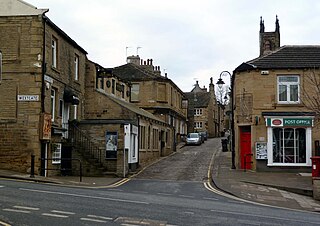
Upperthong is a village approximately 807 feet (246 m) above sea level, near the town of Holmfirth in Holme Valley, approximately 7 miles (11 km) south of Huddersfield, West Yorkshire, England.

Liversedge is a town and former parish of Birstall, in the Metropolitan Borough of Kirklees, West Yorkshire, England. Historically part of the West Riding of Yorkshire, Liversedge lies between Cleckheaton and Heckmondwike. The Kirklees ward is now called Liversedge and Gomersal with a population at the 2011 Census of 19,420. Liversedge forms part of the Heavy Woollen District.

Walkington is a village and civil parish in the East Riding of Yorkshire, England. It is situated approximately 3 miles (4.8 km) to the south-west of the town of Beverley on the B1230 road, and Beverley Grammar School.

Lepton is a village near Huddersfield in the parish of Kirkburton, in the Kirklees district of West Yorkshire, England. It is 4.25 miles (7 km) to the east of Huddersfield on the A642 road, 120 metres (390 ft) above the town centre directly north of Lepton Great Wood. In 1931 the parish had a population of 3,323.

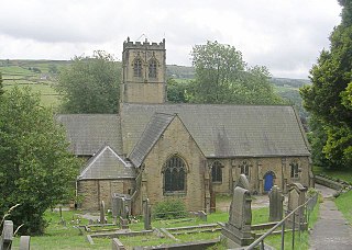
Netherthong is a village and former civil parish, now in the parish of Holme Valley, and the metropolitan borough of Kirklees in West Yorkshire, England. The village is near the town of Holmfirth, and on the B6107 road to Meltham from the main A6024 Woodhead Road through the Holme Valley from Honley to Holmfirth. It has an estimated population of 1,738 (2018).

Norristhorpe is a village in the township of Liversedge in Kirklees, West Yorkshire, England, and is historically part of the West Riding of Yorkshire.

Helme is a small village in the Kirklees district, in the county of West Yorkshire, England. It is near the town of Meltham and Blackmoorfoot Reservoir. Helme, constituted in 1858, was part of Almondbury parish in the 19th century.

Beggarington, also known as Beggerington and Begerington is a hamlet consisting of a few houses about 0.4 miles (0.6 km) north of Hartshead in Kirklees, West Yorkshire. It is situated in a bend of the B6119 road at the junction with the road from Roberttown. Beggerington has traditionally been considered a part of Hartshead. The place name means either "where the berries grow" or is related to beggar.


