Rockaway Beach, Pacifica, California

Last updated • 5 min readFrom Wikipedia, The Free Encyclopedia

Rockaway Beach photographed from the north, at the quarry. Calera Creek is visible. Rockaway Beach, Pacifica, CA.jpg
Rockaway Beach photographed from the north, at the quarry. Calera Creek is visible.

Rockaway Beach is a shoreline area of the Pacific Ocean in the southern portion of Pacifica, California, United States, approximately 7 miles (11 km) south of the city of San Francisco. It is located within a gently curving embayment with direct access via Rockaway Beach Avenue and providing easy access to Highway 1.

Contents

The beach itself is a popular place to visit with many restaurant and shopping venues although erosion has decreased its size over the years. It is noted for its scenic overlook, and is one of the cleanest beaches in the San Francisco Bay Area. [1]

History

There are no known prehistoric remains in Rockaway Beach itself; however, the site of the Ohlone Native American village site of Timigtac [2] is located about a half mile away on Calera Creek, immediately to the east of Rockaway Beach by State Route 1.

The Rockaway beach area has played a role in local history since the arrival of the Portola Expedition, the Spanish explorers credited with discovery of the San Francisco Bay. As early as 1776, limestone quarried in the Rockaway Quarry lime pits was used to whitewash the newly built Presidio of San Francisco . More recent investigations suggest that early settlements in San Pedro Valley also used this limestone for their foundations. In 1907, the Rockaway Beach quarry was established as a continuously-operating commercial entity known as the Stone Brothers. After construction of the Ocean Shore Railroad in 1907, limestone from this quarry was conveyed to assist with the rebuilding of San Francisco after the 1906 San Francisco earthquake. Quarry materials were actually used as ballast for the trackbed of the railroad; moreover, after completion of the railroad, Rockaway Beach was considered a suburb of San Francisco due to convenient access. This all changed after legal problems resulting from landslide repair caused the railroad to go bankrupt in 1921.

Highway 1 was completed from Montara to Rockaway Beach in 1937, thereby reopening the local area again to easy northern access. Horace Hill operated the quarry from the early 1940s to 1953, along with a profitable sand dredging business on the quarry's backside. Ideal Cement took over the quarry operation after that time and owned it until 1971; later operators were Rhodes and Jamison and Quarry Products. The quarry ceased operation in 1987, and is currently (2019) being stabilized and restored. [3]

Natural features

Sunset at Rockaway Beach Sunset at Rockaway Beach in Pacifica.jpg
Sunset at Rockaway Beach

The coastal bluffs have verticality as steep as 60 percent, while some of the quarry surfaces are completely sheer. The limestone beds within the quarry are hard and fresh, with close- and widely-spaced fractures. Some of these beds are underlain by greenstone, an altered volcanic rock that becomes less weathered with depth. The eastern portion of the quarry area is underlain by alluvial terrace deposits. The beach littoral zone is underlain by Holocene age beach sand and the upper sands vary in depth by season, depending on the surf scouring of beach sands in the winter and the gradual rebuilding of sands in the summer.

The beach and headlands are mostly California coastal prairie and northern coastal scrub, while the riparian area of Calera Creek presents the most important upland habitat of the area. Although the beach and headlands area are the least disturbed natural areas of the Rockaway Beach area, they are used moderately as recreation spots. Vegetation is sparse on the beach with occurrences of succulent sea fig, Hottentot fig, and fat hen in the sandy areas. Farther away from the beach there are California poppies, sand verbena, and bush lupines. The near littoral elevation gradually increases toward the north until it reaches a headland peak of 175 feet.

Habitat on the headland east-facing slope consists of northern coastal scrub, considerable prostrate coyote brush, bush monkey flower, and colonies of bush lupine. A gamut of coastal wildflowers inhabit the headland slopes; in addition to California poppy, there are goldenasters, Douglas iris, and many other native species. The steep bluff faces host plants that are tolerant of wind and sea salt mist, such as silver beachweed, sea rocket, and extensive patches of yarrow.

North of the developed area of Rockaway Beach is a hidden quarry, whose habitat is severely disturbed. Rip-rap boulders protect the developed area from marine erosion. Near Calera creek there is aquatic vegetation including rushes, bulrushes, horsetail, fat hen, and plantain. The quarry area hosts a surprising number of amphibians, reptiles, small mammals, and a variety of birds. Avafauna sighted here include herons, egrets, California least terns, and red-winged blackbirds. The headland cliffs within the quarry provide nesting sites for bank swallows, pelagic cormorants, and Brandt's cormorants. Three endangered species are found proximate to Rockaway Beach: the San Francisco garter snake, the San Bruno elfin butterfly, and the California red-legged frog. These last two are found within the quarry property; the California red-legged frog is a critical food source for the San Francisco garter snake that is known to exist on the Mori Point National Park property immediately adjacent to the north.

Developed area

Nicks Rockaway Beach sign.jpg

Hugging the coast at the center of Rockaway Beach is a cluster of restaurants and shops, the oldest of which is a Pacifica landmark, Nick's Seafood Restaurant. Another restaurant, historically the romantic Moonraker, hosts nighttime views over the illuminated waves of the Pacific crashing at the restaurant foundation bulwarks. Newer shops nestle behind the Moonraker, many a product of the city's 1986 redevelopment plan.

See also

Related Research Articles

<span class="mw-page-title-main">Pacifica, California</span> City in San Mateo County, California, US

Pacifica is a city in San Mateo County, California, on the coast of the Pacific Ocean between San Francisco and Half Moon Bay.

<span class="mw-page-title-main">Coquina</span> Sedimentary rock that is composed mostly of fragments of shells

Coquina is a sedimentary rock that is composed either wholly or almost entirely of the transported, abraded, and mechanically sorted fragments of mollusks, trilobites, brachiopods, or other invertebrates. The term coquina comes from the Spanish word for "cockle" and "shellfish".

<span class="mw-page-title-main">Marin Headlands</span> Southernmost peninsula of the Marin Peninsula in California, United States

The Marin Headlands are a hilly peninsula at the southernmost end of Marin County, California, United States, located just north of San Francisco across the Golden Gate Bridge, which connects the two counties and peninsulas. The entire area is part of the Golden Gate National Recreation Area. The Headlands are famous for their views of the Bay Area, especially of the Golden Gate Bridge.

<span class="mw-page-title-main">Calera Creek</span> Stream in Pacifica, California, US

Calera Creek is a stream in the Rockaway Beach and Vallemar neighborhoods of Pacifica, California. The creek is named for the limestone deposits and historical Rockaway Quarry located nearby. With headwaters in the Sweeney Ridge national park, this creek presently enjoys wetlands restoration from the Calera Creek Water Recycling Plant, and contains habitat for the California red-legged frog and San Francisco garter snake.

<span class="mw-page-title-main">Brooks Island Regional Preserve</span> Island in the United States of America

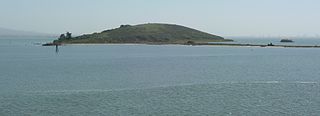
Brooks Island Regional Preserve includes both the 75-acre (30 ha) of Brooks Island above the low-tide line and 300 acres (120 ha) of the surrounding bay. The only public access to the island is via an East Bay Regional Park District naturalist tour.

<span class="mw-page-title-main">Seal Rocks (San Francisco, California)</span> Rock islands in Pacific Ocean in western San Francisco, California

Seal Rock is a group of small rock formation islands in the Lands End area of the Outer Richmond District in western San Francisco, California. They are located just offshore in the Pacific Ocean, at the north end of the Ocean Beach, near the Cliff House and Sutro Baths ruins.

<span class="mw-page-title-main">Golden Gate National Recreation Area</span> U.S. National Recreation Area surrounding San Francisco Bay Area

The Golden Gate National Recreation Area (GGNRA) is a U.S. National Recreation Area protecting 82,116 acres (33,231 ha) of ecologically and historically significant landscapes surrounding the San Francisco Bay Area. Much of the park is land formerly used by the United States Army. GGNRA is managed by the National Park Service and is the second-most visited unit of the National Park system in the United States, with more than 15.6 million visitors in 2022. It is also one of the largest urban parks in the world, with a size two-and-a-half times that of the consolidated city and county of San Francisco.

<span class="mw-page-title-main">San Bruno elfin</span> Subspecies of butterfly

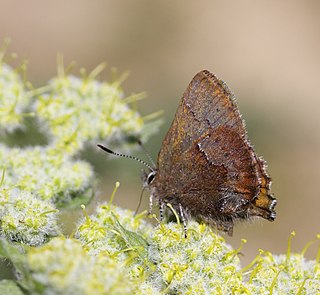
The San Bruno elfin is a U.S. federally listed endangered subspecies that inhabits rocky outcrops and cliffs in coastal scrub on the San Francisco Peninsula. It is endemic to this habitat in California. Its patchy distribution reflects that of its host plant, broadleaf stonecrop.

<span class="mw-page-title-main">Franciscan Complex</span> Late Mesozoic terrane of heterogeneous rocks in the California Coast Ranges

The Franciscan Complex or Franciscan Assemblage is a geologic term for a late Mesozoic terrane of heterogeneous rocks found throughout the California Coast Ranges, and particularly on the San Francisco Peninsula. It was named by geologist Andrew Lawson, who also named the San Andreas Fault that defines the western extent of the assemblage.

<span class="mw-page-title-main">Rodeo Beach</span> Beach in California, US

Rodeo Beach is a beach in the Golden Gate National Recreation Area located in Marin County, California, United States, two miles north of the Golden Gate Bridge. It is characterized by a spit of around 50 meters width at the mouth of a long embayment, known as Rodeo Lagoon; for much of the year the lagoon is cut off from the ocean, making the beach spit a baymouth bar. Part of the beach is sheltered by cliffs. Rodeo Beach is known for its dark, pebbly sand, its uses for surfing and sunbathing, and its locale as a place for viewing, but not collecting, semi-precious stones. This beach is unique among California beaches in that it is largely made up of coarse, pebbly chert grains, both red and green in color. Its mineral composition sets it apart from every other beach in the state. Surfing is possible throughout the year and at all tidal stages, but is best in summer—although there is a risk of shark attacks. Due to the North bar offshore of this beach it results in big waves in the winter months with the big swells that come in. Strong currents make swimming dangerous.

<span class="mw-page-title-main">Pacifica State Beach</span> Ocean beach in California, United States

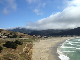
Pacifica State Beach is the southernmost of Pacifica, California's large beaches. It is a 0.75-mile-long (1.21 km) crescent-shaped beach located at the mouth of the San Pedro Valley in downtown Pacifica off State Route 1, in San Mateo County. Over one million people visit this beach annually.

<span class="mw-page-title-main">Pedro Mountain Road</span>

Pedro Mountain Road describes a series of historical road crossings of Pedro Mountain, a promontory ridge located between Montara Mountain and the coastal cliffs of Devil's Slide in San Mateo County, California. This Pedro Mountain headland blocks the easy passage of coastal travelers between the Pedro Valley in Pacifica, California and Montara, California. The most prominent of these Pedro Mountain roads was Coastside Boulevard, the 1914 to 1937 coastal highway 57, which remains in use today as part of the trail network of McNee Ranch State Park.

Graniterock is an American corporation, founded in 1900 as "Granite Rock", and based in Watsonville, California. It operates in the construction industry providing crushed gravel, sand, concrete, asphalt and paving services.

Rockaway Creek is a small creek in the Rockaway Beach neighborhood of Pacifica, California. It is located just south of Calera Creek.

<span class="mw-page-title-main">Mori Point</span>

Mori Point is a 110-acre (0.4 km2) park located in Pacifica, California, that is part of the Golden Gate National Recreation Area (GGNRA). Mori Point itself is a bluff next to the Pacific Ocean that provides scenic views of the peninsula coastline. In addition to the bluff and ridge, Mori Point contains a few small ponds and wetlands. Trails, many newly built, connect the ridgeline to the entrances to the park and to Sharp Park beach. A portion of the California Coastal Trail will run through Mori Point.

<span class="mw-page-title-main">Sweeney Ridge</span>

Sweeney Ridge, is a 1,200-acre (5 km2) hilly hiking area of ridges and ravines between San Bruno and Pacifica, California, about a 25-minute drive south from San Francisco. The ridge's 1,200-foot-high summit, covered with coastal scrub and grassland, slopes down to San Francisco Bay on the east and to the Pacific Ocean on the west. The ridge is part of the Golden Gate National Recreation Area. Historically, the ridge is the location of the San Francisco Bay Discovery Site, commemorating the Portolá expedition's first sighting of San Francisco Bay on November 4, 1769.

<span class="mw-page-title-main">Shelter Cove, Pacifica, California</span>

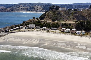
Shelter Cove is a 17-acre (6.9 ha) beach neighborhood at the southerly edge of Pacifica, California consisting of seventeen rustic rental cottages.

Rancho San Pedro was a 8,926-acre (36.12 km2) Mexican land grant in present-day San Mateo County, California given in 1839 by Governor Juan Alvarado to Francisco Sanchez. The grant encompasses present-day Pacifica.

<span class="mw-page-title-main">Devil's Slide Trail</span> Trail located off of Highway 1 between Pacifica and Montara

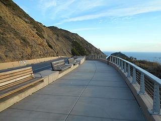
The Devil's Slide Trail is a hiking trail between Pacifica, California, and Montara, California, in the San Francisco Bay Area. The trail is a segment in the California Coastal Trail, which stretches from Oregon to Mexico.

<span class="mw-page-title-main">Rockaway Quarry</span> Limestone quarry in California

The Rockaway Quarry was a Calera limestone quarry in Pacifica, California, in the San Francisco Bay Area. Limestone from the site was first extracted by Ohlone from the village of Pruristac. Beginning in 1776, New Spaniards used California Indian labor to mine limestone and build structures like the Presidio and San Francisco missions. After the 1906 earthquake, the quarry's limestone was used to rebuild San Francisco. By the 1960s, operations declined, and the quarry permanently closed in 1987. Today it is privately held but is used as an informal hiking trail.

References

  1. Bay Area beaches grade well for safe swimming, May 27, 2010 by Carolyn Jones, San Francisco Chronicle
  2. State of California archaeological site CA-SMd-162
  3. History of the Pacifica Quarry, accessed 11/9/2019

Bibliography

37°36′36″N122°29′51″W / 37.61000°N 122.49750°W / 37.61000; -122.49750