Rockaway Quarry

Last updated
Rockaway Quarry
Fishing village on the ocean south of San Francisco, California (cropped).jpg
Rockaway Quarry by Dorothea Lange, 1938
Location
USA California location map.svg
Schlaegel und Eisen nach DIN 21800.svg
Rockaway Quarry
Location in California
Location Rockaway Beach, Pacifica
StateCalifornia
CountryUnited States
Coordinates 37°36′50″N122°29′43″W / 37.613882°N 122.495263°W / 37.613882; -122.495263
Production
ProductsCalera limestone
History
Opened1776
Closed1987

The Rockaway Quarry was a Calera limestone quarry in Pacifica, California, in the San Francisco Bay Area. Limestone from the site was first extracted by Ohlone from the village of Pruristac. Beginning in 1776, New Spaniards used California Indian labor to mine limestone and build structures like the Presidio and San Francisco missions. After the 1906 earthquake, the quarry's limestone was used to rebuild San Francisco. By the 1960s, operations declined, and the quarry permanently closed in 1987. Today it is privately held but is used as an informal hiking trail.

Contents

History

The village of Timigtac was located around the present-day Rockaway Beach area, near Mori Point. [1] A large shellmound in the area indicates the region was long inhabited by the Aramai of the Ramaytush Ohlone. [2] The inhabitants of Timigtac and another nearby village Pruristac actively quarried limestone from the mountain for trade, construction, and decoration. [1] Timigtac and Pruristac were the only Ohlone villages between Montara Mountain and the Golden Gate due to strong coastal winds and sandy soil. [2]

Spanish colonization of San Francisco began in 1769 with the first European sighting of the San Francisco Bay. By 1776, Spanish settlers employed Indian labor to quarry limestone from the Rockaway Quarry to build the San Francisco Presidio and mission buildings. [1] The lime pits were also used to make whitewash. In this period, the quarry was under the control of the Franciscan padres at Mission San Francisco de Asís.

After Mexican Independence and secularization, present-day Pacifica was granted to the mayor of San Francisco and Commandant of the Presidio, Francisco Sánchez, as the Rancho San Pedro. Sánchez used the Rockaway Quarry to produce whitewash for his adobe home, which was completed in 1846. [1]

Following the Mexican–American War, the Rockaway Quarry was sold and quarrying declined. In 1906, however, the dual requirements of Ocean Shore Railroad construction and the 1906 earthquake resulted in the reopening of the Rockaway Quarry in 1907, due to it being one of the few areas in the San Francisco area where limestone was available in industrial quantities. [1] [3] The quarry provided ballast and the trackbed of the railroad, and building material to rebuild the city. The quarry's operators were E.B. and A.L. Stone, who leased the quarry from the Tobin family of San Francisco. [1] [4]

In 1942, the Tobin family transferred ownership to Hibernia Bank. Horace Hill then bought it and established Rockaway Quarry, Incorporated, producing concrete aggregate, ballast, and high-grade limestone during World War II. Other companies began limestone production around Rockaway Beach, and pits appeared on the north and west sides of Mori Point by the 1950s. [1] The Quarry was sold in 1953, and leased to Howard Marks from 1953 to 1968, to Rhodes & Jamieson from 1968 to 1975, and then to the last commercial operations, Quarry Products Incorporated, from 1975 until its closure in 1987. [1]

When commercial quarrying ended, much of the area was left in degraded condition with unstable slopes, bare rocky bluffs, and soil vulnerable to invasive vegetation. Non-native species are still commonly found around the area, and portions of the property were converted into a wastewater treatment plant in 2000. [5]

Geology

Close-up image of Calera Limestone at Rockaway Beach Calera Limestone at Rockaway Beach in California 2.jpg
Close-up image of Calera Limestone at Rockaway Beach

The area lies between the Pilarcitos Fault, the San Andreas Fault, and the San Gregorio Fault. [6] [7] Geologists have dated fossils at the site as between 88 and 105 million years old – in the middle of the long Cretaceous Period. Calera limestone found at Rockaway Quarry is part of a group of Franciscan rocks called the Permanente terrane, which was carried to the ocean's edge through earthquakes over a period of 25 million years. [8] Geochemical studies of Calera limestone show that fragments of the rock may be dismembered oceanic crust. [9]

Reclamation

In January 2023, a reclamation plan was proposed for the Rockaway Quarry site. [10] [11] The plan focused on grading the uneven slopes, replanting native vegetation, and creating a wetlands area. Approval from the California Coastal Commission and the City of Pacifica would be needed for any reclamation project. [10]

Development proposals

There have been multiple efforts over the years to develop the abandoned quarry. In the late-1990s, housing and a convention center were proposed but blocked by local environmental groups. [12] In 2005, a 355 residential units project, a luxury hotel and retail space were voted down by Pacificans in a referendum called Measure L. [13] [14] The property was sold in 2009, and in 2016, Pacifica voters again rejected a development which would have included an office and retail building, 206-unit apartment complex, 188-room hotel, 13,000 square foot conference center, and 12-unit hotel bungalow complex. [15] [16]

See also

Related Research Articles

<span class="mw-page-title-main">Presidio of San Francisco</span> Place in California, United States

The Presidio of San Francisco is a park and former U.S. Army post on the northern tip of the San Francisco Peninsula in San Francisco, California, and is part of the Golden Gate National Recreation Area.

<span class="mw-page-title-main">Pacifica, California</span> City in San Mateo County, California, US

Pacifica is a city in San Mateo County, California, on the coast of the Pacific Ocean between San Francisco and Half Moon Bay.

<span class="mw-page-title-main">Ohlone</span> Native American people of the Northern California coast

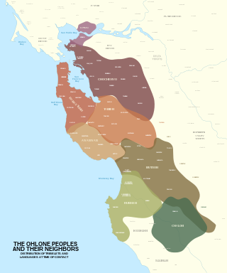
The Ohlone, formerly known as Costanoans, are a Native American people of the Northern California coast. When Spanish explorers and missionaries arrived in the late 18th century, the Ohlone inhabited the area along the coast from San Francisco Bay through Monterey Bay to the lower Salinas Valley. At that time they spoke a variety of related languages. The Ohlone languages make up a sub-family of the Utian language family. Older proposals place Utian within the Penutian language phylum, while newer proposals group it as Yok-Utian.

<span class="mw-page-title-main">Calera Creek</span>

Calera Creek is a stream in the Rockaway Beach and Vallemar neighborhoods of Pacifica, California. The creek is named for the limestone deposits and historical Rockaway Quarry located nearby. With headwaters in the Sweeney Ridge national park, this creek presently enjoys wetlands restoration from the Calera Creek Water Recycling Plant, and contains habitat for the California Red-legged Frog and San Francisco Garter Snake.

<span class="mw-page-title-main">Ramaytush</span> Linguistic subdivision of Ohlone people

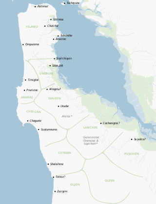
The Ramaytush or Rammay-tuš people are a linguistic subdivision of the Ohlone people of Northern California. The term Ramaytush was first applied to them in the 1970s, but the modern Ohlone people of the peninsula have claimed it as their ethnonym. The ancestors of the Ramaytush Ohlone people have lived on the peninsula—specifically in the area known as San Francisco and San Mateo county—for thousands of years. Prior to the California Genocide, the Ohlone people were not consciously united as a singular socio-political entity. In the early twentieth century anthropologists and linguists began to refer to the Ramaytush Ohlone as San FranciscoCostanoans—the people who spoke a common dialect or language within the Costanoan branch of the Utian family. Anthropologists and linguists similarly called the Tamyen people Santa Clara Costanoans, and the Awaswas people Santa Cruz Costanoans.

<span class="mw-page-title-main">Yelamu</span> Ohlone tribe living in what is now San Francisco, California

The Yelamu are a local tribe of Ohlone people from the San Francisco Bay Area in Northern California. The Yelamu speak a language called Ramaytush. The modern Association of Ramaytush Ohlone (ARO) are the descendants of the Ramaytush.

<span class="mw-page-title-main">Black Mountain (near Los Altos, California)</span>

Black Mountain is a summit on Monte Bello Ridge in the Santa Cruz Mountains of west Santa Clara County, California, south of Los Altos and Los Altos Hills, and west of Cupertino; it is within the Palo Alto city limits though not near the developed part of the city. It is located on the border between Rancho San Antonio Open Space Preserve and Monte Bello Open Space Preserve, with the summit located in the former. Early Spanish explorers commonly named tree- or chaparral-covered summits which look black in the distance Loma Prieta, from the Spanish . The Spanish also called the middle portion of the Santa Cruz Mountains the Sierra Morena meaning, extending from Half Moon Bay Road south to a gap at Lexington Reservoir, and which includes a summit called Sierra Morena. There are over 100 "Black Mountains" in California.

<span class="mw-page-title-main">Rockaway Beach, Pacifica, California</span> Neighborhood

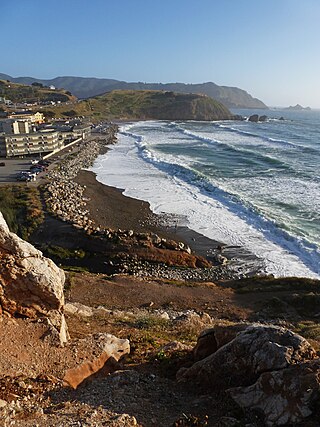
Rockaway Beach is a shoreline area of the Pacific Ocean in the southern portion of Pacifica, California, United States, approximately 7 miles (11 km) south of the city of San Francisco. It is located within a gently curving embayment with direct access via Rockaway Beach Avenue and providing easy access to Highway 1.

<span class="mw-page-title-main">Mussel Rock</span> Island in the United States of America

Mussel Rock is a rock formation on the coast of San Mateo County, California, offshore from Daly City. It consists of one large and numerous smaller rocks of a type known as a stack, where a headland is eroded unevenly, leaving small islands. The rock itself is located 15 meters from the shore of Mussel Rock Park and stands 18 meters tall.

<span class="mw-page-title-main">Franciscan Complex</span> Late Mesozoic terrane of heterogeneous rocks in the California Coast Ranges

The Franciscan Complex or Franciscan Assemblage is a geologic term for a late Mesozoic terrane of heterogeneous rocks found throughout the California Coast Ranges, and particularly on the San Francisco Peninsula. It was named by geologist Andrew Lawson, who also named the San Andreas fault that defines the western extent of the assemblage.

<span class="mw-page-title-main">Sánchez Adobe Park</span> Historic house in California, United States

The Sánchez Adobe Park, home to the Sánchez Adobe, is located in Pacifica, California, at 1000 Linda Mar Boulevard, on the north bank of San Pedro Creek, approximately 0.91 miles (1,470 m) from the Pacific Ocean in Linda Mar Valley. The 5.46-acre (2.21 ha) county park, established in 1947 contains the Sanchez Adobe Historical site, designated a National Register Historical District in 1976 and is California registered landmark 391.

<span class="mw-page-title-main">Mori Point</span>

Mori Point is a 110-acre (0.4 km2) park located in Pacifica, California, that is part of the Golden Gate National Recreation Area (GGNRA). Mori Point itself is a bluff next to the Pacific Ocean that provides scenic views of the peninsula coastline. In addition to the bluff and ridge, Mori Point contains a few small ponds and wetlands. Trails, many newly built, connect the ridgeline to the entrances to the park and to Sharp Park beach. A portion of the California Coastal Trail will run through Mori Point.

<span class="mw-page-title-main">Yerba Buena, California</span> Original name of the Spanish settlement which became San Francisco, California, US

Yerba Buena was the original name of the settlement that later became San Francisco. Located near the northeastern end of the San Francisco Peninsula, between the Presidio of San Francisco and the Mission San Francisco de Asís, it was originally intended as a trading post for ships visiting San Francisco Bay. The settlement was arranged in the Spanish style around a plaza that remains as the present day Portsmouth Square.

<span class="mw-page-title-main">1906 San Francisco earthquake</span> Major earthquake that struck San Francisco and the coast of Northern California

At 05:12 Pacific Standard Time on Wednesday, April 18, 1906, the coast of Northern California was struck by a major earthquake with an estimated moment magnitude of 7.9 and a maximum Mercalli intensity of XI (Extreme). High-intensity shaking was felt from Eureka on the North Coast to the Salinas Valley, an agricultural region to the south of the San Francisco Bay Area. Devastating fires soon broke out in San Francisco and lasted for several days. More than 3,000 people died, and over 80% of the city was destroyed. The event is remembered as the deadliest earthquake in the history of the United States. The death toll remains the greatest loss of life from a natural disaster in California's history and high on the lists of American disasters.

<span class="mw-page-title-main">Santa Teresa Hills</span>

The Santa Teresa Hills are a range of mountains in Santa Clara County, California, located primarily in the city of San Jose. They separate the San Jose neighborhoods of Almaden Valley to the west and Santa Teresa to the east.

<span class="mw-page-title-main">Permanente Quarry</span> Limestone quarry in Santa Clara County, California, USA

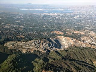
The Permanente Quarry and cement plant is in an unincorporated area of Santa Clara County, California, just west of Cupertino. The limestone and aggregate mining operation and cement plant is owned by Lehigh Southwest Cement, a subsidiary of Heidelberg Cement. Limestone was mined beginning in 1902 but remained a small operation until 1939 when it was purchased by Henry J. Kaiser to supply the 5.5 million barrels of cement to build Shasta Dam. With increased production Kaiser supplied all of the cement used by the Navy in the Pacific Theater of World War 2. At 7 million barrels, it was more cement than the Shasta Dam project. Roughly 70 percent of the cement used in the communities of Santa Clara County was acquired from the cement plant.

Rancho San Pedro was a 8,926-acre (36.12 km2) Mexican land grant in present-day San Mateo County, California given in 1839 by Governor Juan Alvarado to Francisco Sanchez. The grant encompasses present-day Pacifica.

<span class="mw-page-title-main">Permanente Creek</span> River in California, United States

Permanente Creek is a 13.3-mile-long (21.4 km) stream originating on Black Mountain in Santa Clara County, California, United States. Named by early Spanish explorers as Arroyo Permanente or Río Permanente because of its perennial flow, the creek descends the east flank of Black Mountain then courses north through Los Altos and Mountain View, discharging into southwest San Francisco Bay historically at the Mountain View Slough but now virtually entirely diverted via the Permanente Creek Diversion Channel to Stevens Creek and Whisman Slough in San Francisco Bay.

<span class="mw-page-title-main">Hale Creek</span> River in California, United States

Hale Creek is a short stream originating in the foothills of Los Altos Hills, California in Santa Clara County, California, United States. Its source is in the Rancho San Antonio Open Space Preserve, west of Neary Quarry. The creek flows northeasterly 4.6 miles (7.4 km) through the cities of Los Altos Hills, Los Altos, and Mountain View before joining Permanente Creek.

Guadalupe Creek or Guadalupe Valley Creek is a short eastward-flowing stream whose watershed originates just east of the highest peak of San Bruno Mountain in San Mateo County, California, United States. It courses through San Bruno Mountain State and County Park and Brisbane before entering the Brisbane Lagoon.

References

  1. 1 2 3 4 5 6 7 8 "Historic Resource Study for Golden Gate National Recreation Area in San Mateo County" (PDF). National Park Service. Department of Interior. Archived (PDF) from the original on 13 June 2023. Retrieved 4 August 2023.
  2. 1 2 Drake, Bill; Hunter, Chris (2002). Pacifica. Arcadia Publishers. pp. 15–16. ISBN   9780738520681. Archived from the original on 25 May 2017. Retrieved 4 August 2023.
  3. "Limestone". National Park Service. Archived from the original on 7 August 2023. Retrieved 4 August 2023.
  4. "Rockaway Quarry". Pacifica Historical Society. Archived from the original on 10 August 2023. Retrieved 8 August 2023.
  5. "History: Building the Bay Area". The Pacifica Quarry. Archived from the original on 2023-06-08. Retrieved 4 August 2023.
  6. Parsons, Tom (January 1, 2002). Crustal Structure of the Coastal and Marine San Francisco Bay Region, California (PDF). Washington D.C.: U.S. Geological Survey. p. 79. Archived from the original (PDF) on 2023-08-07. Retrieved 4 August 2023.
  7. "The San Andreas and San Gregorio Fault Systems in San Mateo County" (PDF). U.S. Geological Survey. United States Department of the Interior. Archived from the original (PDF) on 2023-08-10. Retrieved 8 August 2023.
  8. Alden, Andrew. "Calera Limestone, a Gift from the Ancient Pacific". KQED. Archived from the original on 7 August 2023. Retrieved 4 August 2023.
  9. Larue, D. K.; Barnes, Ivan; Sedlock, R. L. (April 1989). "Accretionary history of an oceanic crustal assemblage: The Permanente terrane near Pacifica, California". Tectonics. 8 (2): 221–235. Bibcode:1989Tecto...8..221L. doi:10.1029/TC008i002p00221. Archived from the original on 7 August 2023. Retrieved 4 August 2023.
  10. 1 2 Campbell, Eileen. "Planning Commission to discuss reclamation of quarry". Pacifica Tribune. Archived from the original on 7 August 2023. Retrieved 4 August 2023.
  11. "Rockaway Quarry Reclamation Plan Project". CEQA. State of California. Archived from the original on 10 August 2023. Retrieved 8 August 2023.
  12. Stoffer, Philip W. (2005). The San Andreas Fault In The San Francisco Bay Area, California: A Geology Fieldtrip Guidebook To Selected Stops On Public Lands (PDF). Washington D.C.: U.S. Geological Survey. p. 90. ISBN   978-1288733439. Archived from the original (PDF) on 2022-10-06. Retrieved 4 August 2023.
  13. "Pacifica, Brisbane split on quarry measures". San Francisco Examiner. Archived from the original on 7 August 2023. Retrieved 4 August 2023.
  14. "Plans for Rockaway quarry altered". San Francisco Examiner. Archived from the original on 30 August 2023. Retrieved 30 August 2023.
  15. Scott, Julia. "Controversial Pacifica quarry changes hands, future uncertain". The Mercury News. Archived from the original on 2021-03-01. Retrieved 4 August 2023.
  16. Bourne, Jacob. "Pacifica Quarry Development May Go to Voters in November". The Registry. Archived from the original on 2022-09-29. Retrieved 4 August 2023.