Romney Marshes Area internal drainage board is the successor to a long line on organisations who have managed land drainage and flood defence on Romney Marsh in the counties of Kent and East Sussex in the south-east of England.
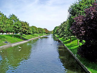
Romney Marshes, along with The Fens and the Somerset Levels, is one of the three major areas of marshland in southern England. It covers some 100 square miles (260km2) of land, and stretches from Hythe in the north east to Fairlight in the south west. To the west, the marshland extends along the valleys of the River Rother, River Tillingham and River Brede. Most of it is low-lying, below the level of high tides, and is susceptible to flooding from the sea and from fresh water. To some extent, it is protected from the English Channel on its south and east sides by large banks of shingle, consisting of flint pebbles, but these are constantly being altered by wave action. Dungeness, at the south-eastern tip, is a large promontary made of shingle.[1] The gaps between the shingle banks have been plugged with sea walls, built over centuries, without which most of the area would quickly revert to salt marsh. Furthest west is Pett Wall, followed by Broomhill Wall, while between Dungeness and Hythe are the Littlestone Wall and Dymchurch Wall.[2]
Much of the marshes became the property of the Priory of Canterbury in the 9th century, when the lands owned by the double minster of Lyminge were transferred to Christ Church, Canterbury.[3] In the early 1100s, Christ Church granted land near Appledore to tenants, who had to maintain sea walls and drainage ditches known as sewers to prevent salt and fresh water flooding the land. Another early reference to flood prevention occurred sometime between 1155 and 1167, when Prior Wilbert of Canterbury granted a tenancy on land in Misleham, now part of Brookland parish, to a man called Baldwin Scudaway for "all their land in Misleham which lies in the Marsh, in so far as Baldwin can inclose it against the sea". Baldwin was required to pay for the sea defences himself, and the main drainage channel near Misleham is still called Baldwin's Sewer.[4][5]
The Doudeman family are one of the best-documented groups involved in reclamation of the marshes in the late 12th and early 13th centuries. They reclaimed a large swathe of land in the parish of Broomhill over four generations. Battle Abbey and Robertsbridge Abbey began buying up land, including some of the Doudeman's, shortly after 1200, and in 1222 joined forces to enclose another 1,400 acres (570ha). The favourable weather conditions of this period were followed by a long period of stormy weather, and a document issued by them in 1243 stated that rent would no longer be payable if the land was overwhelmed by the sea. There are no surviving records of reclamation taking place subsequently.[6]
A significant advance occurred in 1252, when Henry III issued the Charter of Romney Marsh. This prevented the Sheriff or his officers from taking any action which might prevent the Jurats of Romney Marsh from carrying out their responsibilities to protect the land from sea or fresh water flooding.[7] This was one of the first pieces of legislation to recognise that land drainage was a bigger issue than could successfully be dealt with by individuals, and the resultant commission was the forerunner of many local authorities to control the drainage of low-lying areas of England.[8] The charter allowed the Bailiff, Jurats and Commonality of the Marsh of Romney to levy rates, called scots, on occupants of the area to pay for maintaining the land drainage and sea defences, and this practice continued until 1932.[9]
Extreme weather during the 13th century caused numerous issues in the marshes, and the processes for dealing with them were gradually formulated into the Laws and Customs of Romney Marsh. Subsequently, commissions dealing with a number of other areas of marshland in England commanded that they should be managed according to the laws and customs of Romney Marsh.[10]Edward IV[lower-alpha 1] issued another charter to Romney Marsh Corporation in 1462, to introduce liberties which would enable the population to increase, as the area had become depopulated. The ruling body became known as the Lords, Bailiff, Jurats and Commonalty of the Level and Liberty of Romney Marsh, and they were empowered to raise taxes in addition to the scots.[9] The next major advance was the passing of a Land Drainage Act by Henry VIII in 1531. This act created Commissions of Sewers in all of the marshlands of England, apart from Romney Marsh, where the existing system worked so well that the Lords, Bailiff and Jurats continued to manage the land as they had previously done.[10]
Brack pumping station, owned by the IDB, was built in 1909.
Following the passing of the Land Drainage Act 1930, Catchment Boards were set up to manage the main rivers. The Rother and Jury's Gut Catchment Board were responsible for the River Rother, the River Tillingham and the River Brede, while the Romney and Denge Marsh Main Drains Catchment Board were responsible for major waterways on the marsh itself.[11] Within those catchment areas, internal drainage districts were created, to be managed by internal drainage boards (IDBs). They were responsible for the management of land drainage, and the network of channels that supported it.[12] Six IDBs were created to manage the different areas of the marsh, but two of them amalgamated. The Romney Marsh Levels IDB managed the central area of the marsh, while Walland IDB managed Walland Marsh, bounded by Rye to the west, Lydd to the east and Brookland to the north. Denge and Southbrooks IDB managed Denge Marsh, to the east of Lydd, Pett IDB managed the Pett Level, to the south of Winchelsea, and Rother IDB were responsible for the land surrounding the River Rother, River Tillingham and River Brede. The Romney Marshes Area IDB was formed in April 2001, when these five boards amalgamated.[7][13]
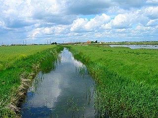
The IDB is responsible for an area of 130 square miles (340km2), although water drains into it from higher ground around its edges, resulting in a catchment area of 360 square miles (930km2). Much of the marsh is lower than the mean tide level, and would be flooded if it were not protected by sea walls. Within their area, they maintain 220 miles (350km) of drainage ditches, which feed water to the main rivers. The IDB owns five pumping stations, but most of the ditches feed water to pumping stations owned by the Environment Agency.[14] They manage a further 31 pumping stations, together with 201 miles (323km) of main river and 82 miles (132km) of embankments and flood walls. The IDB also maintains 140 structures which control water levels.[15]
Brooks, Nicholas (1988). Romney Marsh in the Early Middle Ages. In Eddison & Green 1988
Dobson, Alban; Hull, Hubert (1931). The Land Drainage Act 1930. Oxford University Press.
Eddison, Jill; Green, Christopher, eds. (1988). Romney Marsh: Evolution, Occupation, Reclamation. Oxford University Committee for Archaeology. ISBN978-0-947816-24-7.
Eddison, Jill (2000). Romney Marsh: Survival on a frontier. History Press. ISBN978-0-7524-1486-7.
Tatton-Brown, Tim (1988). The Topography of the Walland Marsh area between the 11th and 13th Centuries. In Eddison & Green 1988
Wisdom, A S (1966). Land Drainage. London: Sweet & Maxwell.
Related Research Articles
Romney Marsh is a sparsely populated wetland area in the counties of Kent and East Sussex in the south-east of England. It covers about 100 square miles (260 km2). The Marsh has been in use for centuries, though its inhabitants commonly suffered from malaria until the 18th century. Due to its location, geography and isolation, it was important for smugglers between the 17th and 19th centuries. The area has long been used for sheep pasture: Romney Marsh sheep are considered one of the most successful and important sheep breeds. Featuring numerous waterways, and with some areas lying below sea level, the Marsh has over time sustained a gradual level of reclamation, both through natural causes and by human intervention.
The River Brede is an English river in East Sussex. It flows into the Rock Channel and then onto the River Rother at Rye, Sussex. It takes its name from the village of Brede, which lies between Hastings and Tenterden.
The River Rother flows for 35 miles (56 km) through the English counties of East Sussex and Kent. Its source is near Rotherfield in East Sussex, and its mouth is on Rye Bay, part of the English Channel. Prior to 1287, its mouth was further to the east at New Romney, but it changed its course after a great storm blocked its exit to the sea. It was known as the Limen until the sixteenth century. For the final 14 miles (23 km), the river bed is below the high tide level, and Scots Float Sluice is used to control levels. It prevents salt water entering the river system at high tides, and retains water in the river during the summer months to ensure the health of the surrounding marsh habitat. Below the sluice, the river is tidal for 3.7 miles (6.0 km).
Rye is a town and civil parish in the Rother district of East Sussex, England, two miles from the sea at the confluence of three rivers: the Rother, the Tillingham and the Brede. An important member of the mediaeval Cinque Ports confederation, it was at the head of an embayment of the English Channel, and almost entirely surrounded by the sea.
The Royal Military Canal is a canal running for 28 miles (45 km) between Seabrook near Folkestone and Cliff End near Hastings, following the old cliff line bordering Romney Marsh, which was constructed as a defence against the possible invasion of England during the Napoleonic Wars.
Brede is a village and civil parish in the Rother district of East Sussex, England. It is located eight miles (13 km) north of Hastings and four miles (6 km) west of Rye.
The Caldicot and Wentloog Levels are two areas of low-lying estuarine alluvial wetland and intertidal mudflats adjoining the north bank of the Severn Estuary, either side of the River Usk estuary near Newport in south east Wales. They are also known collectively as the Monmouthshire Levels or Gwent Levels, and the name Wentloog is sometimes spelled Wentlooge in official publications.
The River Tillingham flows through the English county of East Sussex. It meets the River Brede and the eastern River Rother near the town of Rye. A navigable sluice controlled the entrance to the river between 1786 and 1928, when it was replaced by a vertical lifting gate which was not navigable. The river provided water power to operate the bellows of an iron works at Beckley Furnace, used to make cannons for the Royal Navy between 1578 and 1770, when it became uneconomic, and a water mill which replaced it, until that burnt down in 1909. The lower reaches supported a thriving shipbuilding industry from the early nineteenth century onwards, and although on a smaller scale, was still doing so in 2000.
An internal drainage board (IDB) is a type of operating authority which is established in areas of special drainage need in England and Wales with permissive powers to undertake work to secure clean water drainage and water level management within drainage districts. The area of an IDB is not determined by county or metropolitan council boundaries, but by water catchment areas within a given region. IDBs are geographically concentrated in the Broads, Fens in East Anglia and Lincolnshire, Somerset Levels and Yorkshire.
The Middle Level Commissioners are a land drainage authority in eastern England. The body was formed in 1862, undertaking the main water level management function within the Middle Level following the breakup of the former Bedford Level Corporation.
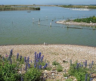
Rye Harbour Site of Special Scientific Interest is a nature reserve located on the western side of the mouth of the River Rother at Rye Harbour, about 1 mile downstream from Rye East Sussex. It forms part of a wide network of SSSI's on the Kent-Sussex border that include the Romney & Walland Marsh, the Dungeness Peninsular, the lower Rother Valley and the Pett Levels.
The Land Drainage Act 1930 was an act of Parliament passed by the United Kingdom Government which provided a new set of administrative structures to ensure that drainage of low-lying land could be managed effectively. It followed the proposals of a royal commission which sat during 1927.
Walland Marsh is a part of Romney Marsh, mostly in Kent with part in East Sussex. The name means wall-land: its north-eastern border, separating it from the rest of Romney Marsh, is the Rhee Wall.
From December 2013 onwards the Somerset Levels suffered severe flooding as part of the wider 2013–2014 Atlantic winter storms in Europe and subsequent 2013–2014 United Kingdom winter floods. The Somerset Levels, or the Somerset Levels and Moors as they are less commonly but more correctly known, is a coastal plain and wetland area of central Somerset, in South West England, running south from the Mendip Hills to the Blackdown Hills.
Denge Marsh, also spelled Dengemarsh and occasionally called the Denge, is a part of Romney Marsh in Kent. Its north-west boundary is the town of Lydd; to the south-east is Denge Beach and Dungeness.
Holderness Drain is the main feature of a Land Drainage scheme for the area of Holderness to the east of the River Hull in the East Riding of Yorkshire, England. Construction began in 1764, and several notable civil engineers were involved with the scheme over the years. Despite the high costs of the initial scheme, it was not particularly successful, because of the refusal of the ship owners of Hull to allow an outlet at Marfleet. They insisted that the water be discharged into the River Hull to keep the channel free of silt. Following a period of agricultural depression and the building of new docks in the early 1800s, an outlet at Marfleet was finally authorised in 1832. A high level system still fed upland water to the Hull, but the low level system discharged into the Humber, where levels were considerably lower. Following the success of steam pumping on the Beverley and Barmston Drain, the trustees looked at such a possibility for the Holderness Drain, but the development of the Alexandra Dock in the 1880s and then the King George V Dock in 1913 provided a solution, as the docks were topped up with water pumped from the drain, to lessen the ingress of silt-laden water.
The Rhee Wall is a former watercourse in Romney Marsh in Kent. It is 7.5 miles (12.1 km) long and runs from Appledore, on the north-western edge of Romney Marsh, south-east through Snargate, Brenzett and Old Romney, to New Romney near the coast. The Rhee Wall forms a boundary between Romney Marsh proper, to the north-east, and Walland Marsh to the south-west.
The Beverley and Barmston Drain is the main feature of a land drainage scheme authorised in 1798 to the west of the River Hull in the East Riding of Yorkshire, England. The area consisted of salt marshes to the south and carrs to the north, fed with water from the higher wolds which lay to the north, and from inundation by tidal water passing up the river from the Humber. Some attempts to reduce the flooding by building embankments had been made by the fourteenth century, and windpumps appeared in the seventeenth century. The Holderness Drainage scheme, which protected the area to the east of the river, was completed in 1772, and attention was then given to resolving flooding of the carrs.
The River Till is a river in the county of Lincolnshire in England and is ultimately a tributary of the River Witham. Its upper reaches drain the land east of Gainsborough. The middle section is embanked, as the water level is higher than that of the surrounding land, and pumping stations pump water from low level drainage ditches into the river. Its lower reaches from the hamlet of Odder near Saxilby into the city of Lincoln were canalised, possibly as early as Roman times, as part of the Foss Dyke.
The Upper Witham IDB is an English Internal Drainage Board responsible for land drainage and the management of flood risk for an area to the west of the Lincolnshire city of Lincoln, broadly following the valleys of the upper River Witham, the River Till and the course of the Fossdyke Navigation.
This page is based on this Wikipedia article Text is available under the CC BY-SA 4.0 license; additional terms may apply. Images, videos and audio are available under their respective licenses.