Ralston Peak is a mountain in the Sierra Nevada mountain range to the west of Lake Tahoe within the Desolation Wilderness in El Dorado County, California. Ralston Peak is a very popular mountain to summit for the views of the wilderness area as it lies very near U.S. Route 50. The closest trailhead to the summit can be found in Camp Sacramento a few miles west of Echo Summit. Ralston Peak can also be accessed from the Pacific Crest Trail between Echo Lake and Lake Aloha. Starting at the nearest trailhead, this route is significantly longer than the trail from Camp Sacramento. But the altitude gain on this route is much less, and the trail is much less steep.

Mount Tallac is a mountain peak southwest of Lake Tahoe, in El Dorado County, California. The peak lies within the Desolation Wilderness in the Eldorado National Forest. It is quite visible from State Routes 89 and 28, and U.S. Route 50. A "cross of snow" is clearly visible on the mountain's face during the winter, spring, and early summer months.

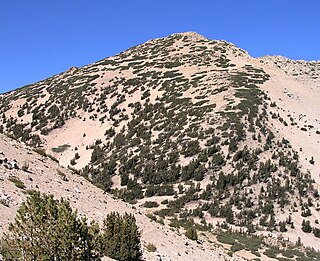
Mount Hooper is a 12,349-foot (3,764 meter) high mountain summit located west of the crest of the Sierra Nevada mountain range in Fresno County of northern California, United States. It is set within the John Muir Wilderness, on land managed by Sierra National Forest. It is situated 4.26 miles (6.86 km) west of Gemini, 3.6 miles (5.8 km) southwest of Seven Gables, and 2.25 miles (3.62 km) west-northwest of Mount Senger. Hooper ranks as the 326th-highest summit in California, and topographic relief is significant as the summit rises over 5,000 feet above Florence Lake in approximately four miles. The John Muir Trail traverses the east slope of the mountain, providing an approach option.

Pilot Knob is a 12,245-foot-elevation (3,732 meter) mountain summit located in Fresno County in the Sierra Nevada mountain range in northern California, United States. It is situated at the intersection of Piute Canyon and French Canyon, in the John Muir Wilderness, on land managed by Sierra National Forest. It is set 2.5 miles (4.0 km) south of Merriam Peak and three miles north of the Matthes Glaciers. Pilot Knob is the 360th-highest peak in California, and topographic relief is significant as the west aspect rises 2,800 feet above Hutchinson Meadow in approximately one mile. This mountain was likely named by the USGS during the 1907–09 survey for the Mt. Goddard Quadrangle, and the toponym has been officially adopted by the U.S. Board on Geographic Names.

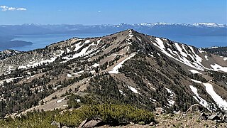
Dicks Peak is a 9,974-foot-elevation (3,040 meter) mountain summit located in the Sierra Nevada mountain range in El Dorado County, California, United States. It is the third-highest peak in the Desolation Wilderness, and is set on land managed by Eldorado National Forest. It is situated six miles (9.7 km) south of Lake Tahoe, and approximately eight miles (13 km) west of the community of South Lake Tahoe. Topographic relief is significant as the west aspect rises over 2,300 feet above Rockbound Valley in approximately one mile. One-half mile east of the peak the Pacific Crest Trail and Tahoe Rim Trail traverse Dicks Pass, which provides an approach option for those climbing the peak. Inclusion on the Sierra Peaks Section peakbagging list generates climbing interest.

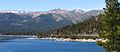
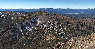
Jakes Peak is a 9,187-foot-elevation (2,800-meter) mountain summit located in the Sierra Nevada mountain range in El Dorado County, California, United States. It is set within the Desolation Wilderness, on land managed by Eldorado National Forest. This iconic peak is situated above the southwest shore of Lake Tahoe, and approximately seven miles (11 km) northwest of the community of South Lake Tahoe. Topographic relief is significant as the east aspect rises 2,950 feet above the lake in 1.5 miles (2.4 km).

Hawkins Peak is a 10,024-foot-elevation (3,055 meter) mountain summit located in Alpine County, California, United States.

Donner Peak is an 8,019-foot-elevation (2,444 meter) summit in Placer County, California, United States.

Mount Lincoln is an 8,383-foot-elevation (2,555 meter) mountain summit in Placer County, California, United States.

Mount Judah is an 8,243-foot-elevation (2,512 meter) mountain summit in Placer County, California, United States.

Sawmill Point is a 9,429-foot-elevation (2,874 meter) mountain summit located in Inyo County, California. It is situated 2.6 miles east of the crest of the Sierra Nevada mountain range, in the John Muir Wilderness, on land managed by Inyo National Forest. It is also 10.5 miles (16.9 km) northwest of the community of Independence, and 2.6 miles (4.2 km) east of proximate parent Colosseum Mountain. Topographic relief is significant as the summit rises 4,770 feet above Owens Valley in two miles. The Sawmill Pass Trail traverses the east and south slopes of the peak, providing an approach option, and access to the John Muir Trail.

Tinker Knob is an 8,949-foot-elevation (2,728 meter) mountain summit in Placer County, California, United States.

Anderson Peak is an 8,683-foot-elevation (2,647 meter) mountain summit in Placer County, California, United States.
Jobs Sister is a mountain summit located near Lake Tahoe in northern California.

Lyon Peak is an 8,891-foot-elevation (2,710 meter) mountain summit in Placer County, California, United States.
Needle Peak is an 8,971-foot-elevation (2,734 meter) mountain summit in Placer County, California, United States.
Relay Peak is a 10,338-foot (3,151 m) mountain summit located in Washoe County, Nevada, United States.
Mount Houghton is a 10,490-foot-elevation mountain summit located in Washoe County, Nevada, United States.

Tamarack Peak is a 9,897-foot-elevation mountain summit located in Washoe County, Nevada, United States.

Twin Peaks is an 8,878-foot-elevation (2,706 meter) double summit mountain in Placer County, California, United States.