Related Research Articles

West Michigan Regional Airport, formerly Tulip City Airport, is a public-use airport located two nautical miles (3.7 km) south of the central business district of Holland, a city in Ottawa County and Allegan County, Michigan, United States. It is included in the Federal Aviation Administration (FAA) National Plan of Integrated Airport Systems for 2017–2021, in which it is categorized as a national general aviation facility.

Cuyahoga County Airport, also known as Robert D. Shea Field, is a public use airport in northeastern Cuyahoga County, Ohio, United States. Owned and operated by Cuyahoga County since 1946, it also serves Lake County and Geauga County. The airport is located 10 nautical miles east of downtown Cleveland and sits on the border of three cities: Highland Heights, Richmond Heights and Willoughby Hills. It is included in the National Plan of Integrated Airport Systems for 2011–2015, which categorized it as a general aviation reliever airport for Cleveland Hopkins International Airport.
Delaware Airpark is a public use airport serving the Dover area. It is owned by the Delaware Department of Transportation and operated by the Delaware River and Bay Authority and located one nautical mile (2 km) west of the central business district of Cheswold, a town in Kent County, Delaware, United States. It is included in the Federal Aviation Administration (FAA) National Plan of Integrated Airport Systems for 2017–2021, in which it is categorized as a local general aviation facility.

Delaware Coastal Airport is a public use airport in unincorporated Sussex County, Delaware, United States. Owned by the Sussex County Council, it is located two nautical miles (4 km) southeast of the central business district of Georgetown. It is included in the Federal Aviation Administration (FAA) National Plan of Integrated Airport Systems for 2017–2021, in which it is categorized as a regional general aviation facility.
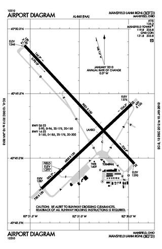
Mansfield Lahm Regional Airport is three miles (5 km) north of Mansfield, in Richland County, Ohio. By car the airport is an hour away from Cleveland and Columbus, near Interstate I-71, US Rt 30, State Route 13.

Moraine Airpark is a public-use airport situated in the city of Moraine, Ohio, United States. 4 miles (6.4 km) southwest of the city of Dayton in Montgomery County. The Airpark originally was called South Dayton Airport which was originally located on Stroop Rd and Lamme Rd in from 1941-1954. It's moved to its current location in 1955 and has been open to the public for the last 68 years (2023). They have everything from a Fairchild to a Christian Eagle based here.Careflight has a hanger for maintenance based there as well. The airpark is the first home base of the National Waco Club. It is also home to a chapter of the Experimental Aircraft Association, which itself holds Young Eagles Days where young pilots are taken for free airplane rides.
Newark–Heath Airport is a public airport located in Heath, Ohio. It is three miles (4.8 km) southwest of the central business district of Newark, a city in Licking County, Ohio, United States. The airport was opened in 1930 by the city of Newark, and was transferred to the Licking County Regional Airport Authority in 1967. The airport currently has a McDonnell Douglas F-4C Phantom II S.N. 64–0683 on static display.

Union County Airport is a public use airport in Union County, Ohio, United States. It is owned by the Union County Airport Authority and located one nautical mile (2 km) southeast of the central business district of Marysville, Ohio. This airport is included in the National Plan of Integrated Airport Systems for 2011–2015, which categorized it as a general aviation facility.

Butler County Regional Airport is a publicly owned, public use airport at 2820 Airport Road East in Hamilton, Ohio. It is owned by the Butler County Board of Commissioners.
Griffing Sandusky Airport was a public airport in Erie County, Ohio, next to Sandusky Bay three miles southeast of Sandusky. The airport permanently closed on December 31, 2013 and the FAA A/FD and VFR sectional charts no longer show the airport as open or operational. Instrument approach procedures are no longer available from the FAA's website. All hangars and the entrance were demolished in April, 2016. The Sandusky Register confirmed that the city announced that a sports park will replace the airport and now has opened in spring 2017 called the Cedar Point Sports Center.
Lake County Executive Airport, formerly Lost Nation Airport, is a public use airport in Lake County, Ohio, United States. Located approximately 3 miles (5 km) north-northeast of the central business district of the City of Willoughby, it was owned and operated by that city until October 8, 2014, when it was transferred to Lake County and the Lake County Port and Economic Development Authority. The airport's name was changed from Lost Nation Airport to Lake County Executive Airport, alternately "Lake County Executive Airport at Lost Nation Field," in March 2020.
Lorain County Regional Airport is a public airport in Lorain County, Ohio, owned by the Lorain County Board of Commissioners and located in New Russia Township. The airport is about 7 miles south of Lorain and 5 miles southwest of Elyria. The National Plan of Integrated Airport Systems for 2011–2015 categorized it as a general aviation reliever airport.
Galion Municipal Airport is three miles northeast of Galion in Crawford County, Ohio. The FAA's National Plan of Integrated Airport Systems for 2009–2013 classified it as a general aviation airport.
Bluffton Airport is a public use airport located one nautical mile (1.85 km) southeast of the central business district of Bluffton, in Hancock County, Ohio, United States. It is owned by the Village of Bluffton. According to the FAA's National Plan of Integrated Airport Systems for 2009–2013, it is categorized as a general aviation facility.
Jack Barstow Airport, also known as Jack Barstow Municipal Airport, is a city-owned, public-use airport located three nautical miles (6 km) northwest of the central business district of Midland, a city in Midland County, Michigan, United States. It is included in the Federal Aviation Administration (FAA) National Plan of Integrated Airport Systems for 2017–2021, in which it is categorized as a local general aviation facility.
Columbiana County Airport is a public airport located four miles northwest of East Liverpool, Ohio, United States. It is owned and operated by the Columbiana County Airport Authority.
South Haven Area Regional Airport is a public-use airport located 3 miles south of South Haven, Michigan. It is publicly owned by the city through the South Haven Area Regional Airport Authority.
Ray Community Airport is a privately owned, public use airport located in Ray Township, Macomb County. Michigan. The airport sits on 93 acres of land at an elevation of 632 feet.
The Port Bucyrus/Crawford County Airport is a publicly owned, public use airport located 1 mile south of Bucyrus in Crawford County, Ohio. The airport sits on 144 acres at an elevation of 1007 feet.
Pickaway County Memorial Airport is a publicly-owned, public-use airport located 5 miles south of Circleville, Ohio. The airport sits on 61 acres at an elevation of 684 feet.
References
- 1 2 "AirNav: KRZT - Ross County Airport". www.airnav.com. Retrieved 2023-08-03.
- 1 2 "RZT - Ross County Airport | SkyVector". skyvector.com. Retrieved 2023-08-03.
- 1 2 "(KRZT) Ross County Airport". Aircraft Owners and Pilots Association. Retrieved 2023-08-03.
- ↑ "Chapters | EAA Chapter 1625". chapters.eaa.org. Experimental Aircraft Association. Retrieved 2023-08-03.
- ↑ Bevens, Bret (2022-09-01). "Historic airplane to come to Ross County Airport". The Pike County News Watchman. Retrieved 2023-08-03.
- ↑ "1928 Ford Tri-Motor Aircraft at Ross County Airport". Lancaster Eagle-Gazette. Retrieved 2023-08-03.
- 1 2 "A Visit to the Ross County Airport". 94 Country WKKJ. Retrieved 2023-08-03.
- ↑ "Brown Announces More Than $80,000 For Ross County Airport Expansion | U.S. Senator Sherrod Brown of Ohio". www.brown.senate.gov. Retrieved 2023-08-03.
- ↑ "TRM Aviation, Inc". Aircraft Owners and Pilots Association. Retrieved 2023-08-03.
- ↑ "TRM Aviation FBO Info & Fuel Prices at Ross County (KRZT)". FlightAware. Retrieved 2023-08-03.
- ↑ "Lawrence County Airpark receives nearly $83K in federal funds". The Tribune. 2022-06-13. Retrieved 2023-08-03.
- ↑ "Incident Mitsubishi MU-2B-30 N618BB, 28 Sep 1996". aviation-safety.net. Retrieved 2023-08-03.
- ↑ "Piper PA 46-350P crash in Ohio (N747RC) | PlaneCrashMap.com". planecrashmap.com. Retrieved 2023-08-03.