Rosslyn Park, South Australia

Last updated

Rosslyn Park
South Australia
CRP-reserve.jpg
Dr Christopher Rawson Penfold Reserve
Population1,469 (SAL 2021) [1]
Established1844
Postcode(s) 5072
Location6 km (4 mi) from Adelaide city centre
LGA(s) City of Burnside
State electorate(s) Bragg
Federal division(s) Sturt
Suburbs around Rosslyn Park:
Tranmere Magill Woodforde
Kensington Gardens Rosslyn Park Auldana
Erindale Wattle Park Skye
Penfolds Magill Estate Magill-estate.jpg
Penfolds Magill Estate

Rosslyn Park is an eastern suburb of Adelaide in the City of Burnside.

Contents

History

Dr Penfold

Most of Rosslyn Park started life as paddocks belonging to Dr Christopher Rawson Penfold, of Penfolds Wine. Dr Penfold was an English emigrant who purchased 500 acres (200 ha) of land in the area in 1844. Here he planted vines and established Penfolds as one of the leading winemakers in Australia. He and subsequent generations of his family resided at the Grange Cottage, to the east of Penfold Road.

Dr Penfold became the first chairman of the District Council of Burnside in 1856.

Sub-division

Upon Dr Penfold's death in 1870, his son-in-law, Thomas Hyland, assumed control of the business, and began to sell some of the land.

The area of Rosslyn Park to the west of Gordon Terrace, between Kensington Road and The Parade, was sold in 1877 to a syndicate made up of:

The syndicate subdivided the land, and sold parcels of it the next year.

Wine production declined at the Rosslyn Park site in the 20th century as production shifted to other areas in South Australia. The last vintage of Penfolds Wine was crushed at Magill Estate in 1972. Prior to and following this, subdivision of the land surrounding Magill Estate continued.

The area bounded by Penfold Road, Park Avenue, Edgcumbe Terrace and The Parade was formerly the site of Joseph Gillard Jnr's (manager at the Grange vineyard) main vineyard. It was sold and subdivided by the Penfolds in around 1912.

The area around Angove Court and Edgcumbe Terrace contains the former family home of Dr Roger Angove, inaugural President of the Burnside Historical Society. This land was subdivided in 1960. The family stables remained until they were demolished by a landowner in 1970.

A larger subdivision occurred in the early 1980s, when owners Tooth & Co sold much of the area to the east of Penfold Road, resulting in the survival of only the core of the former winery, including production plants and Grange Cottage.

Contemporary events

In May 2002, Rosslyn Park experienced an incidence of freak weather when a tornado passed through it and Wattle Park late in the morning. The tornado cut a narrow, 2 km long path of destruction through the suburbs, tearing limbs off trees and tiles from roofs. [2]

Geography

Eucalyptus trees on Edgecumbe Terrace Edgcumbe-tce.jpg
Eucalyptus trees on Edgecumbe Terrace

Rosslyn Park is situated approximately 6 km east of the Adelaide city centre. It is bounded by The Parade to the north, Coach Road to the east, Kensington Road to the south and Hyland Terrace to the west.

The suburb is divided by Penfold Road into two distinct areas. West of Penfold Road, the area is characterised by wide, tree-lined roads and architecture representing many styles popular during the twentieth century. East of Penfold Road, the area is much steeper in its approach to the Adelaide Hills, and contains some large, striking and very modern architecture. Some undeveloped vegetatation, and some of the vines, also remain in this part of the suburb.

Land use

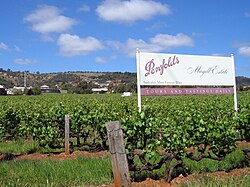
Land use in Rosslyn Park is primarily residential. Penfolds is a notable exception, with its rows of grapevines along Penfold Road a relic of the area's earlier agricultural focus.

Significant places

Grange Cottage Grange-cottage.jpg
Grange Cottage

By far the most notable landmark in Rosslyn Park is the Magill Estate branch of Penfolds Winery. This site offers cellar door sales, tours and the award-winning Penfolds Magill Estate Restaurant. The winery's chimney is visible throughout the area.

Also located at Magill Estate is the historic Grange Cottage. This was constructed by Dr Penfold and his wife, Mary, in 1845, and named after Mary's home town in England. Grange Hermitage wine was in turn named after the cottage.

Other notable locations in Rosslyn Park include:

Street names

Entrance to Mary Penfold Drive Mary-penfold-drive.jpg
Entrance to Mary Penfold Drive

Street names in Rosslyn Park reflect the area's viticultural history and the predilections of its subdividers.

A bus stop on Penfold Road Rosslyn-park-bus-stop.jpg
A bus stop on Penfold Road

Politics

At the Federal level, Rosslyn Park residents are represented in the electorate of Sturt. The member for the seat is currently Christopher Pyne MP. At the state level, the suburb is split between the electorates of Hartley, currently held by Grace Portolesi MP, and Morialta, currently held by John Gardner MP.

Transport

Rosslyn Park is primarily accessed by car and bus. The main roads leading to the suburb are The Parade, Kensington Road and Penfold Road. The Adelaide Metro bus system services Rosslyn Park, with routes H22 and H20 travelling from Grenfell Street in the city to service the area via the Parade, and routes H23 and 141 servicing the area via Kensington Road. The 141 originates from North Terrace in the city, whilst the H23 follows the routes of H20 and H22 before crossing over to Kensington Road via Portrush Road. Bike lanes also exist most of the way along the Parade into the suburb, whilst the development of a 'bicycle boulevard' on the suburban Beulah Road also promotes bicycle usage in the area.

Related Research Articles

<span class="mw-page-title-main">Surry Hills, New South Wales</span> Suburb of Sydney, New South Wales, Australia

Surry Hills is an inner-east suburb of Sydney, in the state of New South Wales, Australia. Surry Hills is immediately south-east of the Sydney central business district in the local government area of the City of Sydney. Surry Hills is surrounded by the suburbs of Darlinghurst to the north, Chippendale and Haymarket to the west, Moore Park and Paddington to the east and Redfern to the south. It is often colloquially referred to as "Surry".

<span class="mw-page-title-main">Kensington, New South Wales</span> Suburb of Sydney, New South Wales, Australia

Kensington is a suburb in the Eastern Suburbs of Sydney, in the state of New South Wales, Australia. It is located 4 kilometres south-east of the Sydney central business district, in the local government area (LGA) of the City of Randwick. Colloquially, Kensington is referred to as "Kenso", "Ensington" or "Enso".

<span class="mw-page-title-main">Norwood, South Australia</span> Suburb of Adelaide, South Australia

Norwood is a suburb of Adelaide, about 4 km (2.5 mi) east of the Adelaide city centre. The suburb is in the City of Norwood Payneham & St Peters, whose predecessor was the oldest South Australian local government municipality.

<span class="mw-page-title-main">City of Burnside</span> Local government area in South Australia

The City of Burnside is a local government area in the South Australian city of Adelaide stretching from the Adelaide Parklands into the Adelaide foothills with an area of 2,753 hectares. It was founded in August 1856 as the District Council of Burnside, the name of a property of an early settler, and was classed as a city in 1943. The LGA is bounded by Adelaide, Adelaide Hills Council, Campbelltown, Mitcham, Norwood Payneham and St Peters and Unley.

<span class="mw-page-title-main">Minchinbury, New South Wales</span> Suburb of Sydney, New South Wales, Australia

Minchinbury is a small suburb in western Sydney, in the state of New South Wales, Australia. Minchinbury is located 38 kilometres (24 mi) west of the Sydney central business district, in Blacktown local government area and is part of the Greater Western Sydney region.

<span class="mw-page-title-main">Grange, South Australia</span> Suburb of Adelaide, South Australia

Grange is a coastal suburb of the City of Charles Sturt, in Adelaide, South Australia, located about 11 kilometres (6.8 mi) from the Adelaide city centre. The suburb is named after Captain Charles Sturt's cottage, built in 1840–41, which still stands and is now a museum. In addition to Grange Beach, the suburb has several parks and reserves, as well as the Grange Hotel, which was originally licensed in 1881.

<span class="mw-page-title-main">Clarendon, South Australia</span> Suburb of City of Onkaparinga, South Australia

Clarendon is a small town in the Adelaide Hills, about 25–30 kilometres (16–19 mi) south of the Adelaide city centre and now regarded as an outer suburb of Adelaide. It lies within the City of Onkaparinga council area. The Clarendon Weir is located in the town area, on the Onkaparinga River.

<span class="mw-page-title-main">Hazelwood Park, South Australia</span> Suburb of Adelaide, South Australia

Hazelwood Park is an upper class suburb in the City of Burnside, Adelaide, South Australia with a census area population of 1,717 people. The suburb is about 5 kilometres east of the Central business district. Hazelwood Park, a suburban park inside the suburb, is the major attraction in the suburb and is the start of the flat country of the Adelaide Plains at the bottom of the Adelaide Hills. Adjacent Howard Terrace is considered to be the end of the Plains and the start of the foothills. Hazelwood Park includes the Burnside Swimming Centre, a popular site in the summer. Much of the remainder of the suburb is residential but there is a small shopping area along Glynburn Road on the eastern edge. The area was first settled by Europeans in 1848 but has seen many community changes over the years.

Kensington Gardens is an eastern suburb of Adelaide, in the City of Burnside. It includes a large recreational park, Kensington Wama, or Kensington Gardens Reserve.

<span class="mw-page-title-main">Magill, South Australia</span> Suburb of Adelaide, South Australia

Magill is a suburb of Adelaide straddling the City of Burnside and City of Campbelltown council jurisdictions, approximately 7 km from the Adelaide CBD. It incorporates the suburb previously known as Koongarra Park.

<span class="mw-page-title-main">Stonyfell, South Australia</span> Eastern suburb of Adelaide, in the City of Burnside council area, South Australia

Stonyfell is an eastern suburb in the foothills of Adelaide, Australia, within the council area of the City of Burnside. It has parks with walking tracks, and two creeks running through it. St Peter's Collegiate Girls' School is the only school in Stonyfell. There is a quarry and a winery, the present-day remnants of industries dating back to the early days of the colonisation of South Australia.

<span class="mw-page-title-main">Toorak Gardens, South Australia</span> Suburb of Adelaide, South Australia

Toorak Gardens is a leafy, mainly residential inner eastern suburb of Adelaide, South Australia, located 2 km east of the Adelaide city centre.

Wattle Park is a suburb of Adelaide, South Australia in the City of Burnside.

Marryatville is a small suburb about 4–5 kilometres (2.5–3.1 mi) east of Adelaide's central business district, in the local council area of City of Norwood Payneham St Peters. Comprising low- to medium-density housing, two large schools, a church and several shops, it also has two creeks running through it. The first European settler on the land was George Brunskill in 1839, with part of the land purchased and laid out as a village in 1848 by James Philcox.

<span class="mw-page-title-main">History of the City of Burnside</span> History of area in Adelaide, Australia

The history of the City of Burnside, a local government area in the metropolitan area of Adelaide, spans three centuries. Prior to European settlement Burnside was inhabited by the Kaurna people, who lived around the creeks of the River Torrens during the winter and in the Adelaide Hills during the summer.

<span class="mw-page-title-main">Penfolds</span> Winery in South Australia

Penfolds is an Australian wine producer that was founded in Adelaide in 1844 by Christopher Rawson Penfold, an English physician who emigrated to Australia, and his wife Mary Penfold. It is one of Australia's oldest wineries, and is currently part of Treasury Wine Estates.

<span class="mw-page-title-main">Baskerville, Western Australia</span> Suburb of Perth, Western Australia

Baskerville is an outer northeastern rural suburb of Perth, Western Australia, in the Swan Valley region, 31 km from Perth's central business district via Midland and Great Northern Highway. Nearly all of it is under cultivation with viticulture being the main economic activity, and several well-established Swan Valley wineries are based here. Its local government area is the City of Swan.

<span class="mw-page-title-main">South Australian wine</span>

The South Australian wine industry is responsible for more than half the production of all Australian wine. South Australia has a vast diversity in geography and climate which allows the state to be able to produce a range of grape varieties–from the cool climate Riesling variety in the Clare Valley wine region to the big, full bodied Shiraz wines of the Barossa Valley.

Mary Penfold, née Holt, was an English businesswoman, pioneering winemaker and co-founder of Penfolds Winery.

Thomas Francis Hyland was a businessman of Victoria, Australia, instrumental in turning Penfolds Wines from a cottage industry to an Australian icon.

References

  1. Australian Bureau of Statistics (28 June 2022). "Rosslyn Park (Suburb and Locality)". Australian Census 2021 QuickStats. Retrieved 28 June 2022.  OOjs UI icon edit-ltr-progressive.svg
  2. Bureau of Meteorology – Significant Weather May 2002, www.bom.gov.au

Coordinates: 34°55′20″S138°40′31″E / 34.9221°S 138.6754°E / -34.9221; 138.6754