
Neatishead is a village and civil parish in the English county of Norfolk. The village is situated some 20 km (12 mi) north-east of the city of Norwich, within The Norfolk Broads and to the west of Barton Broad. Access to Neatishead from the broad is by way of Limekiln Dyke, a narrow channel leading off the broad.

Congleton was, from 1974 to 2009, a local government district with borough status in Cheshire, England. It included the towns of Congleton, Alsager, Middlewich and Sandbach. The headquarters of the borough council were located in Sandbach.

Withernsea is a seaside resort town and civil parish in the East Riding of Yorkshire, England, and forms the focal point for a wider community of small villages in Holderness. Its most famous landmark is the white inland lighthouse, rising around 127 feet (39 m) above Hull Road. The lighthouse – no longer active – now houses a museum to 1950s actress Kay Kendall, who was born in the town.
Hockley is a large village and civil parish in Essex in the East of England located between Chelmsford and Southend-on-Sea, or, more specifically, between Rayleigh and Rochford. It came to prominence during the coming of the railway in the 1890s and at the 2001 census had a population of 13,616 people, reducing to 9,616 at the 2011 Census, many of whom commute to London. The parish of Hockley itself has a population of 8,909, while the urban area runs into the neighbouring parish of Hawkwell. Hockley railway station serves the village.
Radford Semele is a village and civil parish in Warwickshire, England, situated close to the Regency spa town of Leamington Spa. According to the 2001 Census, Radford Semele parish had a population of 2,034, reducing to 2,012 at the 2011 Census. It lies on the A425 between Leamington and Southam. It has a 16th-century pub with a priest hole. The local school is the Radford Semele Church of England School. This is a primary school and most senior pupils go to school in either Southam, Leamington Spa or Warwick which are close by. As well as the parish church of St Nicholas the village also has a second church built in 1874, the Radford Semele Baptist Church.
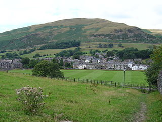
Sedbergh is a town and civil parish in Cumbria, England. The 2001 census gave the parish a population of 2,705, increasing at the 2011 census to 2,765. Historically in the West Riding of Yorkshire, it lies about 10 miles (16 km) east of Kendal, 28 miles (45 km) north of Lancaster and about 10 miles (16 km) north of Kirkby Lonsdale, just within the Yorkshire Dales National Park. It stands at the foot of Howgill Fells, on the north bank of the River Rawthey, which joins the River Lune 2 miles (3 km) below the town.

Haughton is a village and civil parish which lies northwest of Nantwich in the unitary authority of Cheshire East and the ceremonial county of Cheshire, England. According to the 2001 Census, its population was 223, reducing to 204 at the 2011 Census, and has four fully active farms.

Grayrigg is a small village and civil parish in the South Lakeland district of Cumbria, England. In the 2001 census the parish had a population of 223, decreasing at the 2011 census to 242. It lies on undulated and partly mountainous land, 4.9 miles (8 km) north east of Kendal, on the north side of the West Coast Main Line, and west side of the M6 motorway.

Alstonefield is a village and civil parish in the Peak District National Park and the Staffordshire Moorlands district of Staffordshire, England about 7 miles (11 km) north of Ashbourne, 10 miles (16 km) east of Leek and 16 miles (26 km) south of Buxton. The parish had a population of 274 according to the 2001 census, increasing to 304 at the 2011 census.

Bisham is a village and civil parish in the Royal Borough of Windsor and Maidenhead in Berkshire, England. The village is on the River Thames, around one mile (1.6 km) south of Marlow in the neighbouring county of Buckinghamshire, and around three miles (5 km) northwest of Maidenhead. At the 2011 Census, the population of the parish was 1,099, down from 1,149 at the 2001 Census. Bisham is home to one of Sport England's National Sports Centres.

Hale is a village and civil parish in the Halton unitary authority of Cheshire, England. According to the 2001 census it had a population of 1,898, decreasing to 1,841 by the 2011 census. The village is north of the River Mersey, and just to the east of the boundary with Merseyside. It is 2½ miles east of Speke in Liverpool, and 4 miles south-west of Widnes. The nearby village of Halebank is to the north-east.

The Llŷn Peninsula extends 30 miles (50 km) into the Irish Sea from North West Wales, south west of the Isle of Anglesey. It is part of the historic county of Caernarfonshire, and historic region and local authority area of Gwynedd. Much of the eastern part of the peninsula, around Criccieth, may be regarded as part of Eifionydd rather than Llŷn, although the boundary is somewhat vague. The area of Llŷn is about 400 km2 (150 sq mi), and its population is at least 20,000.

Slaugham is a village and civil parish in the Mid Sussex District of West Sussex, England. It is located 7 miles (11 km) to the south of Crawley, on the A23 road to Brighton. The civil parish covers an area of 2,432 hectares. At the 2001 census it had a population of 2,226 persons of whom 1,174 were economically active. At the 2011 Census the parish included the villages of Handcross and Warninglid and had a population of 2,769. In addition the parish contains the settlement of Pease Pottage.
Wyre Forest is a local government district in Worcestershire, England, covering the towns of Kidderminster, Stourport-on-Severn and Bewdley, and several civil parishes and their villages. Its council was previously based in Stourport-on-Severn, but moved to new purpose built offices on the outskirts of Kidderminster in 2012.

Llangynog is a village and community at the confluence of the Afon Eirth and the Afon Tanat at the foot of the Berwyn range in north Powys, Wales.

Lea is a civil parish in the unitary authority of Cheshire East and the ceremonial county of Cheshire, England, which lies to the north east of Audlem and to the south of Crewe. The parish is predominantly rural, but it includes the hamlet of Lea Forge. Nearby villages include Betley, Blakenhall, Hough, Walgherton and Wybunbury.

Great Whelnetham is a village and civil parish in the West Suffolk district of Suffolk in eastern England. Located around two miles south of Bury St Edmunds, in 2005 its population was 820.
Rushock is a small village in Herefordshire, England. It lies about 1 mile north-east of Kington. The population of the civil parish was 131 at the 2011 census.

A civil parish is a country subdivision, forming the lowest unit of local government in England. There are 218 civil parishes in the ceremonial county of Cornwall, which includes the Isles of Scilly. The county is effectively parished in its entirety; only the unpopulated Wolf Rock is unparished. At the 2001 census, there were 501,267 people living in the current parishes, accounting for the whole of the county's population. The final unparished areas of mainland Cornwall, around St Austell, were parished on 1 April 2009 to coincide with the structural changes to local government in England.

