Halton Hills is a town in the Regional Municipality of Halton, located in the northwestern end of the Greater Toronto Area, Ontario, Canada with a population of 61,161 (2016).
The Town of Mono is situated in south-central Ontario, Canada, at the south-east corner of Dufferin County. It stretches from Highway 9 along its southern border to Highway 89 along its northern border. Its border to the west is with the Township of Amaranth and in the east it is bordered by the Township of Adjala-Tosorontio. It was previously known as the Township of Mono.

The Nottawasaga River is a river in Simcoe County and Dufferin County in Central Ontario, Canada. It is part of the Great Lakes Basin, and is a tributary of Lake Huron. The river flows from the Orangeville Reservoir in the town of Orangeville, Dufferin County, through the Niagara Escarpment and the Minesing Wetlands, the latter a wetland of international significance, and empties into Nottawasaga Bay, an inlet of Georgian Bay on Lake Huron, at the town of Wasaga Beach, Simcoe County.

Flamborough is a district and former municipality in the city of Hamilton, Ontario, Canada. For most of its existence before amalgamation with Hamilton in 2001, Flamborough comprised the former townships of East Flamborough, West Flamborough, and Beverly, as well as the village of Waterdown. The largest suburban community is the former village of Waterdown containing perhaps one third of its thirty thousand or so inhabitants. Other Flamborough communities include Carlisle, Christie's Corners, Clappison's Corners, Copetown, Freelton, Greensville, Lynden, Kirkwall, Millgrove, Mountsberg, Orkney, Peter's Corners, Rockton, Troy, Sheffield, Valens, Strabane and Westover.

Mulmur is a township in Dufferin County in Southern Ontario, Canada. There are a number of original settlements such as Mulmur Corners, some of which can still be identified as to location, including Rosemont and Stanton.

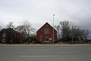
Airlie is an unincorporated rural community in Simcoe County, Ontario, Canada.

Hurontario Street is a roadway running in Ontario, Canada between Lake Ontario at Mississauga and Lake Huron's Georgian Bay at Collingwood. Within Peel Region, it is a major urban thoroughfare within the cities of Mississauga and Brampton, which serves as the divide from which cross-streets are split into East and West, except at its foot in the historic Mississauga neighbourhood of Port Credit. Farther north, with the exception of the section through Simcoe County, where it forms the 8th Concession, it is the meridian for the rural municipalities it passes through. In Dufferin County, for instance, parallel roads are labelled as EHS or WHS for East of Hurontario Street.

Effingham is a hamlet on 12 Mile Creek, in the northern part of the Town of Pelham in Ontario, Canada. Located on the Niagara Escarpment, it has few roads which wind through the Escarpment's forests.

Lion's Head is a community in the municipality of Northern Bruce Peninsula, Bruce County, Ontario, Canada. Located at the midway point of the Bruce Peninsula, about halfway between Owen Sound and Tobermory, Lion's Head is just east of Ferndale on Bruce Road 9. Lion's Head is located on or somewhere near the 45th parallel north, halfway between the Equator and the North Pole. The town is named after the resemblance of a lion's profile in the rock formation of the Niagara Escarpment. The first post office opened in 1895. The estimated summer population ranges widely from 900 to 5000.
Melancthon is a rural Canadian township in the northwest corner of Dufferin County, Ontario, bordered on the east by Mulmur Township, Amaranth Township and East Luther Grand Valley to the south, Southgate Township to the west, and the Municipality of Grey Highlands to the north. The township does not include the town of Shelburne on its southern border. It has one of the lowest population densities in southwestern Ontario.

Jordan is a community located on the eastern edge of the Town of Lincoln, in the Niagara Region. Jordan is bordered by the Twenty Mile Creek and Vineland to the west, Lake Ontario to the north, St. Catharines to the east, and Pelham to the south. Lying roughly 100 km from Toronto and 65 km from Buffalo by road, Jordan is located along a major transportation corridor between Canada and the United States. In January 2014 Jordan was brought to international attention when Al-Qaeda-directed terrorists were arrested for plotting to derail a passenger train traveling from Toronto to New York on a rail-bridge crossing the Jordan Harbour.
Mount Albion was a village located in the County of Wentworth. It was situated near Albion Falls at the north end of the Red Hill Creek Valley, in what is now east Hamilton, Ontario. Mount Albion was an important community in its area throughout the 19th century, as it featured a grist mill, blacksmith shops, taverns, a church and a general store.

Banda is an unincorporated rural community in Dufferin County, Ontario, Canada.

Scotch Block is an unincorporated community in Halton Hills, Ontario, Canada.

Living Springs is an unincorporated rural community in Centre Wellington Township, Wellington County, Ontario, Canada. The settlement was part of West Garafraxa Township until 1999.

Hockley Valley Provincial Nature Reserve is a nature reserve located on the Niagara Escarpment within the township of Mono, Ontario, Canada. It is managed by Ontario Parks. Approximately 80% of the Cannings Falls Area of Natural and Scientific Interest is within the borders of the park; land acquisitions are planned to encompass it entirely. The Bruce Trail links the reserve to other protected areas of the Niagara Escarpment.
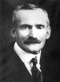
Erland Lee was a Canadian farmer, teacher, and government employee from Stoney Creek, Ontario who is most well known for his role in the founding of the Women's Institutes, an international organization originally formed to promote the education of isolated rural women.

The Erland Lee Museum is a National Historic Site of Canada located on the ridge of the Niagara Escarpment in Stoney Creek, Ontario. Originally a farmhouse belonging to Erland and Janet Lee, the museum is recognized as the birthplace of the first Women's Institutes, an international organization formed in 1897 to promote the education of isolated rural women.
Palermo, founded as Hagartown, is a former village in Halton County, Ontario, Canada which has been amalgamated into the town of Oakville.

Creek Bank is an unincorporated rural community in Centre Wellington Township, Wellington County, Ontario, Canada.