Altenburger Land is a district in Thuringia, Germany. It is bounded by the district of Greiz, the Burgenlandkreis (Saxony-Anhalt), and the districts Leipzig, Mittelsachsen and Zwickau in Saxony. The district is a member of the Central German Metropolitan Region.
Groß-Gerau is a Kreis (district) in the south of Hesse, Germany. Neighboring districts are Main-Taunus, district-free Frankfurt, Darmstadt-Dieburg, Bergstraße, Alzey-Worms, Mainz-Bingen, and the district-free cities Mainz and Wiesbaden.

The Burgenlandkreis was a district (Kreis) in the south of Saxony-Anhalt, Germany. Neighboring districts are Merseburg-Querfurt, Weißenfels, Leipziger Land, Aschersleben-Staßfurt, Altenburger Land, Greiz, district-free Gera, Saale-Holzland, Weimarer Land, Sömmerda and the Kyffhäuserkreis.
Gotha is a Kreis (district) in western central Thuringia, Germany. Neighboring districts are Unstrut-Hainich-Kreis, Sömmerda, the Kreis-free city Erfurt, Ilm-Kreis, Schmalkalden-Meiningen and the Wartburgkreis.
Greiz is a Kreis (district) in the east of Thuringia, Germany. Neighboring districts are Saale-Holzland, Saale-Orla, district-free city Gera, the Burgenlandkreis in Saxony-Anhalt, Altenburger Land, and the two Saxon districts Zwickau and Vogtlandkreis.
Ilm-Kreis is a district in Thuringia, Germany. It is bounded by the city of Erfurt, the districts of Weimarer Land, Saalfeld-Rudolstadt and Hildburghausen, the city of Suhl, and the districts of Schmalkalden-Meiningen and Gotha. It is named after the river Ilm, flowing through the district.
Nordhausen is a Kreis (district) in the north of Thuringia, Germany. Neighboring districts are : Harz and Mansfeld-Südharz in Saxony-Anhalt; Kyffhäuserkreis and Eichsfeld in Thuringia; and Göttingen and Goslar in Lower Saxony.
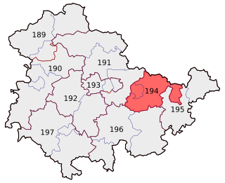
Saale-Orla is a Kreis (district) in the east of Thuringia, Germany. Neighboring districts are the districts Saale-Holzland, Greiz, the Vogtlandkreis in Saxony, the Bavarian districts Hof and Kronach, and the district Saalfeld-Rudolstadt.
Saalfeld-Rudolstadt is a Kreis (district) in the south of Thuringia, Germany. Neighboring districts are the districts Weimarer Land, Saale-Holzland, Saale-Orla, the district Kronach in Bavaria, and the districts Sonneberg, Hildburghausen and Ilm-Kreis.
Schmalkalden-Meiningen is a Landkreis in the southwest of Thuringia, Germany. Its neighboring districts are the districts Wartburgkreis, Gotha, Ilm-Kreis, the district-free city Suhl, the district Hildburghausen, the Bavarian district Rhön-Grabfeld, and the district Fulda in Hesse.
Sömmerda is a Kreis (district) in the north of Thuringia, Germany. Neighboring districts are the districts Kyffhäuserkreis, the Burgenlandkreis in Saxony-Anhalt, the district Weimarer Land and the district-free city Erfurt, and the districts Gotha and Unstrut-Hainich-Kreis.
Weimarer Land is a Landkreis (district) in the east of Thuringia, Germany. Neighboring districts are the district Burgenlandkreis in Saxony-Anhalt, the district Saale-Holzland and the district-free city Jena, the district Saalfeld-Rudolstadt, Ilm-Kreis, and the district-free city Erfurt. The district-free city Weimar is completely enclosed by the district.

Saxe-Weimar-Eisenach was a German state, created as a duchy in 1809 by the merger of the Ernestine duchies of Saxe-Weimar and Saxe-Eisenach, which had been in personal union since 1741. It was raised to a grand duchy in 1815 by resolution of the Congress of Vienna. In 1903, it officially changed its name to the Grand Duchy of Saxony, but this name was rarely used. The grand duchy came to an end in the German Revolution of 1918–19 with the other monarchies of the German Empire. It was succeeded by the Free State of Saxe-Weimar-Eisenach, which was merged into the new Free State of Thuringia two years later.

The Weimar–Gera railway is a line in the German state of Thuringia, connecting the city of Weimar via Jena, Stadtroda and Hermsdorf to Gera. It was built by the Weimar-Gera Railway Company, which was founded in June 1872, and the line was officially accepted into operation in June 1876.
Gera – Jena – Saale-Holzland-Kreis was one of the 299 single member constituencies used for the German parliament, the Bundestag. One of nine districts covering the state of Thuringia, it covered the cities of Gera and Jena and the Saale-Holzland district.
The Thuringian Holzland is an upland region in the state of Thuringia, Germany.

The Verkehrsverbund Mittelthüringen (VMT) is a transport association in central Thuringia, Germany. It comprises the cities of Erfurt, Weimar, Jena, and Gera, as well as parts of the districts of Weimarer Land, Sömmerda, Gotha, Ilm-Kreis, Saale-Holzland-Kreis, and Burgenlandkreis.
Saale-Holzland-Kreis I is an electoral constituency represented in the Landtag of Thuringia. It elects one member via first-past-the-post voting. Under the current constituency numbering system, it is designated as constituency 35. It covers the southern part of Saale-Holzland-Kreis.
Lobeda is a former independent city in Thuringia, Germany, which is now a district of Jena known as Lobeda-Old Town. It was incorporated in 1946, has just under 2000 inhabitants on an area of 3.36 square kilometers and is located just under 4.5 kilometers south of the city center.


