
Mohave County is in the northwestern corner of the U.S. state of Arizona. As of the 2020 census, its population was 213,267. The county seat is Kingman, and the largest city is Lake Havasu City. It is the fifth largest county in the United States.

The Colorado Plateau, also known as the Colorado Plateau Province, is a physiographic and desert region of the Intermontane Plateaus, roughly centered on the Four Corners region of the southwestern United States. This province covers an area of 336,700 km2 (130,000 mi2) within western Colorado, northwestern New Mexico, southern and eastern Utah, northern Arizona, and a tiny fraction in the extreme southeast of Nevada. About 90% of the area is drained by the Colorado River and its main tributaries: the Green, San Juan, and Little Colorado. Most of the remainder of the plateau is drained by the Rio Grande and its tributaries.

At 1.6 million acres the Kaibab National Forest borders both the north and south rims of the Grand Canyon, in north-central Arizona. It is divided into three major sections: the North Kaibab Ranger District and the South Kaibab and are managed by the United States Forest Service. The South Kaibab is further divided into two districts, the Tusayan Ranger District, and the Williams Ranger District. Grand Canyon National Park separates the North Kaibab and the South Kaibab. The South Kaibab covers 1,422 square miles (3,680 km2) and the North Kaibab stretches over 1,010 square miles (2,600 km2). Elevations vary on the forest from 5,500 feet in the southwest corner to 10,418 feet at the summit of Kendrick Peak on the Williams Ranger District. The forest as a whole is headquartered in Williams.

Grand Canyon–Parashant National Monument is located on the northern edge of the Grand Canyon in northwest Arizona. The monument was established by Presidential Proclamation 7265 on January 11, 2000.

The Superstition Mountains is a range of mountains in Arizona located to the east of the Phoenix metropolitan area. They are anchored by Superstition Mountain, a large mountain that is a popular recreation destination for residents of the Phoenix, Arizona, area. They are roughly bounded by U.S. Route 60 on the south, Arizona State Route 88 on the northwest, and Arizona State Route 188 on the northeast.
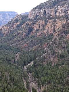
Oak Creek Canyon is a river gorge located in northern Arizona between the cities of Flagstaff and Sedona. The canyon is often described as a smaller cousin of the Grand Canyon because of its scenic beauty. State Route 89A enters the canyon on its north end via a series of hairpin turns before traversing the bottom of the canyon for about 13 miles (21 km) until the highway enters the town of Sedona.

The Nankoweap Trail is an unmaintained hiking trail on the North Rim of the Grand Canyon National Park, located in the U.S. state of Arizona. The Nankoweap trail descends 6,040 feet in 14 miles from the Saddle Mountain trailhead to Nankoweap Creek and on to the Colorado River. It is considered to be the hardest of the trails into the Canyon. Hikers have to carry and cache water as there is none in the 11 miles between the trailhead and Nankoweap Creek.

The Mazatzal Mountains are a mountain range in south central Arizona, about 30–45 miles northeast of the Phoenix metropolitan area. The origin of the name remains obscure but one possibility is that it is from the Nahuatl language meaning "place of the deer". The crest of the Mazatzals forms the county line between Maricopa County and Gila County. SR 87, the Beeline Highway, traverses the Mazatzals on its way to Payson. The highest peak is Mazatzal Peak at 7,903 feet (2,409 m). They also include the Four Peaks, with elevation 7,659 ft, 2,334 m; a prominent mountain and landmark of the eastern Phoenix area.

The Muggins Mountains is a mountain range in southwest Arizona east of Yuma, Arizona, northeast of the Gila Mountains, and east of the Laguna Mountains. The Castle Dome Mountains lie to the northeast across the broad Castle Dome Plain. The Muggins Mountains Wilderness occupies the southwest portion of the range.

The Galiuro Mountains are a large sky island mountain range of southeast Arizona, United States. It is a northerly mountain range in the Madrean Sky Islands region of southeast Arizona, northern Sonora in northwestern Mexico, and the extreme southwest of New Mexico.

The Black Hills of Yavapai County are a large mountain range of central Arizona in southeast Yavapai County. It is bordered by the Verde Valley to the east. The northwest section of the range is bisected from the southeast section by Interstate 17, which is the main route connecting Phoenix to Sedona, Oak Creek Canyon, and Flagstaff. This bisection point is the approximate center of the mostly northwest by southeast trending range. The northwest section contains a steep escarpment on the northeast with the Verde Valley, the escarpment being the location of the fault-block that created the historic mining district at Jerome. The United Verde Mine was one of the largest copper mines in the United States, producing large quantities of copper, gold, silver and zinc.

The Hurricane Cliffs of southwest Utah and northwest Arizona are a red, limestone geographic feature, sets of cliffs along the western, eroded edge of the Kaibab Limestone; the cliffs are about 135-mi (217 km) long, with the south end terminus just north of the Grand Canyon.

The Kanab Plateau is a 45-mile long plateau located at the north of the Grand Canyon in Arizona, United States. The plateau is adjacent west of the Kaibab Plateau of the North Rim, with a basin containing the Kanab Creek watershed in between. The basin is the site of the Kanab Creek Wilderness, with Snake Gulch at its north perimeter, and at the base of the Kanab Plateau, forming its southeast border.

The Toroweap Fault of northwest Arizona and southwest Utah is part of a fault system of the west Grand Canyon region, Arizona, US; also the west perimeter regions of the Coconino and Colorado Plateaus. The Hurricane Fault originates at the Toroweap Fault, in the region of the Colorado River, and strikes as the westerly depression of the Toroweap Fault. The Toroweap strikes northerly from the Colorado at the east of Toroweap Valley, and enters south Utah; from the Colorado River, the Hurricane Fault strikes north-northwest along the west flank of the small, regional Uinkaret Mountains, the west border of Toroweap Valley. The Hurricane Fault, and the Hurricane Cliffs strike into southwest Utah as part of the west, and southwest perimeter of the Colorado Plateau. The Hurricane Cliffs are made of Kaibab Limestone, an erosion resistant, cliff-forming rock unit.

Isis Temple is a prominence in the Grand Canyon, Arizona, Southwestern United States. It is located below the North Rim and adjacent to Granite Gorge. The prominence lies north of the north bank of the west-flowing Colorado River and is just north of Granite Gorge. The Trinity Creek and canyon flow due south at its west border; its north, and northeast border/flank is formed by Phantom Creek and canyon, a west tributary of Bright Angel Creek; the creeks intersect about 3 mi (4.8 km) southeast, and 1.0 mi (1.6 km) north of Granite Gorge. The Isis Temple prominence, is only about 202 ft (62 m) lower than Grand Canyon Village, the main public center on Grand Canyon’s South Rim.

The Grand Wash Cliffs extend south-southeast from the Grand Canyon-Parashant National Monument in northwest Arizona west of the Shivwits Plateau south through the Grand Cliffs Wilderness and into the Lake Mead Recreation Area. The Grand Wash Cliffs cross the Grand Canyon where the Colorado River enters Lake Mead. To the south of the Grand Canyon the Grand Wash Cliffs continue past the east side of Grapevine Mesa and then southeast above and east of the Hualapai Valley forming the southwest margin of the Music Mountains.
Saddle Mountain Wilderness is a protected wilderness area managed by the Kaibab National Forest north of Grand Canyon National Park in the U.S. state of Arizona. Established in 1984 under the Arizona Wilderness Act, the area on the Kaibab Plateau includes its namesake summit, a prominent ridge shaped like a saddle that reaches an elevation of 8,424 feet. Elevations in the northern part of the wilderness on the edge of Marble Canyon start at about 6,000 feet and rise to 8,000 on the southern ridge which forms the Nankoweap Rim of the Grand Canyon.

Brady Peak is an 8,121-foot (2,475 m)-elevation summit located in the Grand Canyon, in Coconino County of northern Arizona, United States. It is situated one mile (1.6 km) northeast of the Vista Encantada viewpoint on the canyon's North Rim, where it towers 4,800 feet (1,500 m) above the bottom of Nankoweap Canyon. Its nearest higher neighbor is Mount Hayden, two miles (3.2 km) to the north, Kibbey Butte is one mile to northwest, and Alsap Butte lies one mile to the northeast. Brady Peak is named after Peter Rainsford Brady (1825–1902), a pioneer and politician of the Arizona Territory. This geographical feature's name was officially adopted in 1932 by the U.S. Board on Geographic Names. According to the Köppen climate classification system, Brady Peak is located in a cold semi-arid climate zone.

Mount Raymond is a 10,241-foot elevation (3,121 m) mountain summit located in Salt Lake County, Utah, United States.


