Saint-Léonard Aerodrome | |||||||||||
---|---|---|---|---|---|---|---|---|---|---|---|
Summary | |||||||||||
Airport type | Public | ||||||||||
Owner | J.D. Irving Ltd. [1] | ||||||||||
Location | Saint-Léonard, New Brunswick | ||||||||||
Time zone | AST (UTC−04:00) | ||||||||||
• Summer (DST) | ADT (UTC−03:00) | ||||||||||
Elevation AMSL | 794 ft / 242 m | ||||||||||
Coordinates | 47°09′26″N067°50′11″W / 47.15722°N 67.83639°W Coordinates: 47°09′26″N067°50′11″W / 47.15722°N 67.83639°W | ||||||||||
Map | |||||||||||
Runways | |||||||||||
| |||||||||||
Statistics (2006) | |||||||||||
| |||||||||||
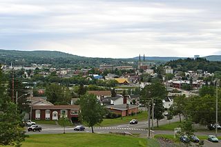
Saint-Léonard Aerodrome( IATA : YSL, ICAO : CYSL) is located 4 nautical mile s (7.4 km; 4.6 mi) southeast of Saint-Léonard, New Brunswick, Canada.
An IATA airport code, also known as an IATA location identifier, IATA station code or simply a location identifier, is a three-letter code designating many airports around the world, defined by the International Air Transport Association (IATA). The characters prominently displayed on baggage tags attached at airport check-in desks are an example of a way these codes are used.
The ICAOairport code or location indicator is a four-letter code designating aerodromes around the world. These codes, as defined by the International Civil Aviation Organization and published in ICAO Document 7910: Location Indicators, are used by air traffic control and airline operations such as flight planning.
A nautical mile is a unit of measurement used in both air and marine navigation, and for the definition of territorial waters. Historically, it was defined as one minute of a degree of latitude. Today it is defined as exactly 1852 metres. The derived unit of speed is the knot, one nautical mile per hour.
The city of Edmundston purchased the airport for $1 and subsequently transferred the ownership to Madawaska Airport Authority. In July 2015, Madawaska Airport Authority announced it would shut down some of the airport operations. J.D. Irving and local community groups intervened to halted the closure of the airport. In October 2017, J.D. Irving purchased the airport for $100,000. [1]
Edmundston is a city in Madawaska County, New Brunswick, Canada.
The airport had regularly scheduled flights to Montreal (Dorval) on Air Nova for part of the 1980s and 1990s.
Montreal is the most populous municipality in the Canadian province of Quebec and the second-most populous municipality in Canada. Originally called Ville-Marie, or "City of Mary", it is named after Mount Royal, the triple-peaked hill in the heart of the city. The city is centred on the Island of Montreal, which took its name from the same source as the city, and a few much smaller peripheral islands, the largest of which is Île Bizard. It has a distinct four-season continental climate with warm to hot summers and cold, snowy winters.
Air Nova was an airline based in Enfield, Nova Scotia, Canada that became part of Air Canada Regional in 2001. In 2002 the merger of Air BC, Air Ontario, Air Nova and Canadian Regional Airlines was finalised with the launch of a new name and brand-Air Canada Jazz.
Clearwater Aerodrome, is a private airfield run by the Irving Oil company in Clearwater, New Brunswick, Canada.
Havre Saint-Pierre Airport,, is located 3 nautical miles north of Havre-Saint-Pierre, Quebec, Canada. It serves Labrador, the lower and central North Shore and southern Quebec, including Anticosti Island.
Saint-Dominique Aerodrome is located at Saint-Dominique, Quebec, Canada.
Madawaska Valley Airpark or Barry's Bay/Madawaska Valley Airpark,, is located 3 nautical miles northeast of Barry's Bay, Ontario, Canada.
Madawaska Collins Field Aerodrome,, is located 0.32 nautical miles north of Madawaska, Ontario, Canada.
METAR is a format for reporting weather information. A METAR weather report is predominantly used by pilots in fulfillment of a part of a pre-flight weather briefing, and by meteorologists, who use aggregated METAR information to assist in weather forecasting.
Nav Canada is a privately run, not-for-profit corporation that owns and operates Canada's civil air navigation system (ANS). It was established in accordance with the Civil Air Navigation Services Commercialization Act.
This article about an airport in New Brunswick is a stub. You can help Wikipedia by expanding it. |