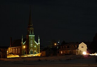
Saint-Philippe-de-Néri, Quebec

Last updated
Saint-Philippe-de-Néri
Parish municipality
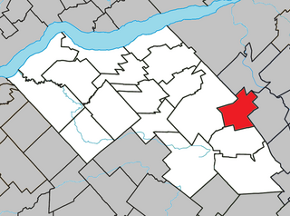
Saint-Philippe-de-Neri Quebec location diagram.png
Location within Kamouraska RCM
Canada Eastern Quebec location map.png
Red pog.svg
Saint-Philippe-de-Néri
Location in eastern Quebec
Coordinates: 47°28′N69°53′W / 47.467°N 69.883°W / 47.467; -69.883 Coordinates: 47°28′N69°53′W / 47.467°N 69.883°W / 47.467; -69.883 [1]
CountryFlag of Canada.svg  Canada
Province Flag of Quebec.svg  Quebec
Region Bas-Saint-Laurent
RCM Kamouraska
Constituted December 29, 1875
Government [2]
  Mayor Gilles Lévesque
   Federal riding Montmagny—L'Islet—Kamouraska—Rivière-du-Loup
   Prov. riding Côte-du-Sud
Area [2] [3]
  Total 32.60 km2 (12.59 sq mi)
  Land 33.41 km2 (12.90 sq mi)
 There is an apparent contradiction between two authoritative sources
Population (2011) [3]
  Total 868
  Density 26.0/km2 (67/sq mi)
  Pop 2006-2011Decrease2.svg 2.4%
  Dwellings 384
Time zone EST (UTC−5)
  Summer (DST) EDT (UTC−4)
Postal code(s) G0L 4A0
Area code(s) 418 and 581
Highways
Quebec Autoroute 20.svgTrans-Canada Highway shield.svg A-20 (TCH)

Qc230.svg Route 230
Qc287.svg Route 287
Website www.st-philippe.com

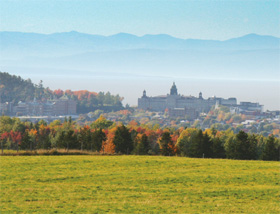
Saint-Philippe-de-Néri is a parish municipality in the Canadian province of Quebec, located in the Kamouraska Regional County Municipality.

Provinces and territories of Canada Top-level subdivisions of Canada

The provinces and territories of Canada are the sub-national governments within the geographical areas of Canada under the authority of the Canadian Constitution. In the 1867 Canadian Confederation, three provinces of British North America—New Brunswick, Nova Scotia, and the Province of Canada —were united to form a federated colony, becoming a sovereign nation in the next century. Over its history, Canada's international borders have changed several times, and the country has grown from the original four provinces to the current ten provinces and three territories. Together, the provinces and territories make up the world's second-largest country by area.
Quebec Province of Canada

Quebec is one of the thirteen provinces and territories of Canada. It is bordered to the west by the province of Ontario and the bodies of water James Bay and Hudson Bay; to the north by Hudson Strait and Ungava Bay; to the east by the Gulf of Saint Lawrence and the province of Newfoundland and Labrador; and to the south by the province of New Brunswick and the U.S. states of Maine, New Hampshire, Vermont, and New York. It also shares maritime borders with Nunavut, Prince Edward Island, and Nova Scotia. Quebec is Canada's largest province by area and its second-largest administrative division; only the territory of Nunavut is larger. It is historically and politically considered to be part of Central Canada.

Kamouraska Regional County Municipality Regional county municipality in Quebec, Canada

Kamouraska is a regional county municipality in eastern Quebec, Canada. Regional County municipality seat is Saint-Pascal. The other main town is La Pocatière.

Contents

See also

Municipal council

Related Research Articles

Drummondville City in Quebec, Canada

Drummondville is a city in the Centre-du-Québec region of Quebec, located east of Montreal on the Saint-François River. The population as of the Canada 2016 Census was 68,601. The mayor of Drummondville is Alexandre Cusson.

Saint-Narcisse-de-Beaurivage, Quebec Parish municipality in Quebec, Canada

Saint-Narcisse-de-Beaurivage is a parish municipality in the Lotbinière Regional County Municipality in the Chaudière-Appalaches region of Quebec, Canada. Its population is 1,091 as of the Canada 2011 Census. It was named after the Narcisse Dionne, an early benefactor of the parish. Beaurivage is associated to the seigneurie of Beaurivage, also known as Saint-Gilles.

Saint-Augustin-de-Woburn Parish municipality in Quebec, Canada

Saint-Augustin-de-Woburn, known locally as Woburn, is a parish municipality in Le Granit Regional County Municipality in the Estrie region of Quebec, Canada, on the Canada–United States border. The population is 695 as of the Canada 2011 Census.

Notre-Dame-du-Mont-Carmel, Quebec Parish municipality in Quebec, Canada

Notre-Dame-du-Mont-Carmel is a parish municipality in the Mauricie region of the province of Quebec in Canada.

Parisville, Quebec Parish municipality in Quebec, Canada

Parisville is a parish municipality in the Centre-du-Québec region of the province of Quebec in Canada.

Sainte-Sophie-de-Lévrard, Quebec Parish municipality in Quebec, Canada

Sainte-Sophie-de-Lévrard is a parish municipality in the Centre-du-Québec region of the province of Quebec in Canada.

Mont-Carmel, Quebec Municipality in Quebec, Canada

Mont-Carmel is a municipality in the Canadian province of Quebec, located in the Kamouraska Regional County Municipality, on the Canada–United States border.

Saint-Bruno-de-Kamouraska Municipality in Quebec, Canada

Saint-Bruno-de-Kamouraska is a municipality in the Canadian province of Quebec, located in the Kamouraska Regional County Municipality.

Saint-Gabriel-Lalemant, Quebec Municipality in Quebec, Canada

Saint-Gabriel-Lalemant is a municipality in the Canadian province of Quebec, located in the Kamouraska Regional County Municipality. The municipality is named for St. Gabriel Lalemant, one of the Canadian Martyrs.

Saint-Pacôme Municipality in Quebec, Canada

Saint-Pacôme is a municipality in the Canadian province of Quebec, located in the Kamouraska Regional County Municipality.

Sainte-Anne-de-la-Pocatière Parish municipality in Quebec, Canada

Sainte-Anne-de-la-Pocatière is a parish municipality in the Canadian province of Quebec, located in the Kamouraska Regional County Municipality.

Saint-Onésime-dIxworth, Quebec Municipality in Quebec, Canada

Saint-Onésime-d'Ixworth is a municipality in the Canadian province of Quebec, located in the Kamouraska Regional County Municipality.

Saint-Mathieu-de-Rioux, Quebec Parish municipality in Quebec, Canada

Saint-Mathieu-de-Rioux is a parish municipality in the Canadian province of Quebec, located in the Les Basques Regional County Municipality.

Saint-Fabien, Quebec Parish municipality in Quebec, Canada

Saint-Fabien is a parish municipality in the Canadian province of Quebec, located in the Rimouski-Neigette Regional County Municipality.

Saint-Honoré-de-Shenley, Quebec Municipality in Quebec, Canada

Saint-Honoré-de-Shenley is a municipality in the Beauce-Sartigan Regional County Municipality in the Chaudière-Appalaches region of Quebec, Canada. Its population is 1,610 as of 2011.

Sainte-Hénédine, Quebec Parish municipality in Quebec, Canada

Sainte-Hénédine is a parish municipality in La Nouvelle-Beauce Regional County Municipality in the Chaudière-Appalaches region of Quebec, Canada. Its population is 1,212 as of the Canada 2011 Census.

Sainte-Marie, Quebec City in Quebec, Canada

Sainte-Marie is a city in the province of Quebec. It is the seat of the Municipalité régionale de la Nouvelle-Beauce, in Chaudière-Appalaches. The population was 12,889 as of the Canada 2011 Census, and was 99.0% French-speaking as of 2006. It is located 59 kilometres (37 mi) south-east of Quebec City, on the Chaudière River.

Saint-Simon, Bas-Saint-Laurent, Quebec Parish municipality in Quebec, Canada

Saint-Simon is a parish municipality in the Les Basques Regional County Municipality in the Bas-Saint-Laurent region of Quebec, Canada. Its population in the Canada 2011 Census was 438.

Saint-Paul-de-la-Croix, Quebec Parish municipality in Quebec, Canada

Saint-Paul-de-la-Croix is a parish municipality in Quebec, Canada, in the regional county municipality of Rivière-du-Loup Regional County Municipality and the administrative region of Bas-Saint-Laurent.

Saint-Malo, Quebec Municipality in Quebec, Canada

Saint-Malo is a municipality in Quebec, Canada, on the Canada–United States border. Saint-Malo has the highest elevation of any municipality in Quebec. At 640 metres (2,100 ft), local residents live in an environment of forests, farms, and waterways that supply their livelihood.

References