
Port Allen is a city in, and the parish seat of, West Baton Rouge Parish, Louisiana, United States. Located on the west bank of the Mississippi River, it is bordered by Interstate 10 and US Highway 190. The population was 5,180 at the 2010 census, down from 5,278 in 2000. It is part of the Baton Rouge Metropolitan Statistical Area.

Saint Anthony Falls, or the Falls of Saint Anthony located at the northeastern edge of downtown Minneapolis, Minnesota, is the only natural major waterfall on the Mississippi River. Throughout the mid-to-late 1800’s, various dams were built atop the east and west faces of the falls to support the milling industry that spurred the growth of the city of Minneapolis. In 1880, the central face of the falls was reinforced with a sloping timber apron to stop the upstream erosion of the falls. In the 1950s, the apron was rebuilt with concrete, which makes up the most visible portion of the falls today. A series of locks were constructed in the 1950s and 1960s to extend navigation to points upstream.
A grain elevator is a facility designed to stockpile or store grain. In the grain trade, the term "grain elevator" also describes a tower containing a bucket elevator or a pneumatic conveyor, which scoops up grain from a lower level and deposits it in a silo or other storage facility.

The Stone Arch Bridge is a former railroad bridge crossing the Mississippi River at Saint Anthony Falls in downtown Minneapolis, Minnesota. It is the only arched bridge made of stone on the entire Mississippi River. It is the second oldest bridge on the river next to Eads Bridge. The bridge was built to connect the railway system to the new Union Depot, which at that time was planned to be built between Hennepin Avenue and Nicollet Avenue. The bridge was completed in 1883, costing $650,000 at the time. 117 Portland Avenue is the general address of the historic complex.

Nicollet Island is an island in the Mississippi River just north of Saint Anthony Falls in central Minneapolis, Minnesota. According to the United States Census Bureau the island has a land area of 194,407 square metres (0.075 sq mi) and a 2000 census population of 144 persons. The island makes up a large part of the city-designated Nicollet Island/East Bank neighborhood. The island is named for cartographer Joseph Nicollet, who mapped the Upper Mississippi in the 1830s.

Downtown Memphis, Tennessee is the central business district of Memphis, Tennessee and is located along the Mississippi River between Interstate 40 to the north, Interstate 55 to the south and I-240 to the east, where it abuts Midtown Memphis.

The Mississippi National River and Recreation Area is a 72-mile (116 km) and 54,000-acre (22,000 ha) protected corridor along the Mississippi River through the Minneapolis–Saint Paul metro in the U.S. state of Minnesota, from the cities of Dayton and Ramsey, to just downstream of Hastings. This stretch of the upper Mississippi River includes natural, historical, recreational, cultural, scenic, scientific, and economic resources of national significance. This area is the only national park site dedicated exclusively to the Mississippi River. The Mississippi National River and Recreation Area is sometimes abbreviated as MNRRA or MISS, the four letter code assigned to the area by the National Park Service. The Mississippi National River and Recreation Area is classified as one of four national rivers in the United States, and despite its name it is technically not one of the 40 national recreation areas.

Bohemian Flats Park is a park in Minneapolis, Minnesota, United States on the west bank of the Mississippi River near the Washington Avenue Bridge and next to the University of Minnesota campus. The area, once known as Little Bohemia, was the site of a shanty town as Minneapolis was incorporated in 1867. European immigrants seeking employment in the city or at the mills at the nearby St. Anthony Falls settled there. The former housing structures and historic buildings no longer remain. The park is managed by the Minneapolis Park and Recreation Board as part of the Mississippi Gorge Regional Park, and it lies within the Mississippi National River Recreation Area.

The Stockyards Exchange is a building in South St. Paul, Minnesota, United States, built in 1887 by the recently formed Union Stock Yards Company of Omaha. The building housed businesses associated with the nearby stockyards, which later became the largest stockyards in the United States. It also housed a post office, city offices, and the city's first bank, Stockyards National Bank.
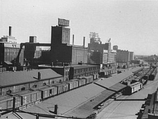
Northwestern Consolidated Milling Company was an American flour milling company that operated about one quarter of the mills in Minneapolis when the city was the flour milling capital of the world. Formed as a business entity, Northwestern produced flour for the half century between 1891 and 1953, when its A Mill was converted to storage and light manufacturing. At its founding, Northwestern was the city's and the world's second largest flour milling company after Pillsbury, with what is today General Mills a close third. The company was touched by an attempt at U.S. monopoly and became part of a Minneapolis oligopoly that valued in 1905 owned almost 9% of the country's flour and grist products.
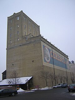
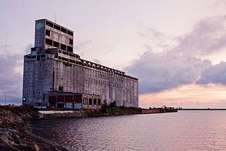
Northwestern Consolidated Milling Company Elevator A also known as the Ceresota Elevator and "The Million Bushel Elevator" was a receiving and public grain elevator built by the Northwestern Consolidated Milling Company in 1908 in Minneapolis, Minnesota in the United States. The elevator may have been the largest brick elevator ever constructed and ran on electricity. The elevator was the source for the Crown Roller Mill and Standard Mill. Those mills closed in the 1950s but the elevator continued in use for grain storage until the mid 1980s. The building is a contributing property of the Saint Anthony Falls History District listed in the National Register of Historic Places in 1971.
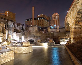
Mill Ruins Park is a park in downtown Minneapolis, Minnesota, United States, standing on the west side of Saint Anthony Falls on the Mississippi River and running from 3rd Ave. S. to about 9th Ave. S. The park interprets the history of flour milling in Minneapolis and shows the ruins of several flour mills that were abandoned.

This is a list of the National Register of Historic Places listings in Dakota County, Minnesota. It is intended to be a complete list of the properties and districts on the National Register of Historic Places in Dakota County, Minnesota, United States. Dakota County is located in the southeastern part of the U.S. state of Minnesota, bounded on the northeast side by the Upper Mississippi River and on the northwest by the Minnesota River. The locations of National Register properties and districts for which the latitude and longitude coordinates are included below, may be seen in an online map.

Saint Paul is the second largest city in the U.S. state of Minnesota, the county seat of Ramsey County, and the state capital of Minnesota. The origin and growth of the city were spurred by the proximity of Fort Snelling, the first major United States military installation in the area, as well as by the city's location on the northernmost navigable port of the Upper Mississippi River.

The Lowertown Historic District is a historic district in the Lowertown neighborhood of Saint Paul, Minnesota, United States. This 16-block warehouse and wholesaling district comprises 37 contributing properties built 1870s–1920. It was listed on the National Register of Historic Places in 1983 for the significance of its river and rail connections, economic impact, architecture, and urban planning. Lowertown was originally the lower landing on the Mississippi River; the first port of access to the Twin Cities. Several warehouse, railroad, banking, and distribution buildings served the entire Upper Midwest from 1880 to 1920. A significant concentration of these buildings survive, unified by similar architectural styles and construction materials. Many were designed by the city's most prestigious architects, including Cass Gilbert and Clarence H. Johnston Sr.

Mill City Museum is a Minnesota Historical Society museum in Minneapolis. It opened in 2003 built in the ruins of the Washburn "A" Mill next to Mill Ruins Park on the banks of the Mississippi River. The museum focuses on the founding and growth of Minneapolis, especially flour milling and the other industries that used hydropower from Saint Anthony Falls.

The Jefferson Grain Warehouse is a historic warehouse in Jefferson Township, Minnesota, United States, built in 1868 on the bank of the Mississippi River. The warehouse was listed on the National Register of Historic Places in 1994 for having local significance in the themes of commerce and transportation. It was nominated for being a rare surviving reminder of a brief period when wheat was becoming the most important agricultural crop of the Upper Midwest yet steamboats were still the leading form of transportation.
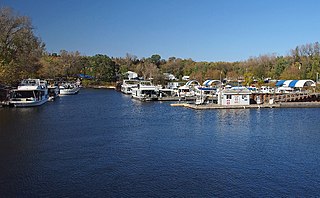
Watergate Marina is located on the north bank of the Mississippi River in Saint Paul, Minnesota, United States, upriver from the city's downtown area. Owned by the City of Saint Paul and operated via lease, the privately run, full-service marina has capacity for 160 ships and it charges fees for boat launches.


