Salazie

Last updated
Salazie
Reunion SalazieTownhall.JPG
Salazie town hall
Blason DomFr Salazie (Reunion).svg
Reunion-Salazie.png
Location of Salazie
Salazie
Coordinates: 21°01′39″S55°32′24″E / 21.0275°S 55.5400°E / -21.0275; 55.5400
Country France
Overseas region and department Réunion
Arrondissement Saint-Benoît
Canton Saint-André-3
Intercommunality Réunion Est
Government
  Mayor (20232026) Sidoleine Papaya [1]
Area
1
103.82 km2 (40.09 sq mi)
Population
 (Jan. 2021) [2]
7,243
  Density70/km2 (180/sq mi)
Time zone UTC+04:00
INSEE/Postal code
97421 /97433
Elevation230–3,071 m (755–10,075 ft)
(avg. 446 m or 1,463 ft)
1 French Land Register data, which excludes lakes, ponds, glaciers > 1 km2 (0.386 sq mi or 247 acres) and river estuaries.
Waterfall of the Trou de fer Reunion TrouDeFer Fall.JPG
Waterfall of the Trou de fer

Salazie (French pronunciation: [salazi] ) is a volcanic caldera and commune (administrative division) of the Indian Ocean island of Réunion, which is an overseas department and region of France.

Contents

The first settlement of the area took place in 1829 after a cyclone had devastated the nearby coast, and the municipality of Salazie was formed in 1889. The name of the commune is potentially derived from the Malagasy word salazy, meaning 'good encampment'. [3]

Geography

Salazie lies in the middle of island, north-east of Piton des Neiges (the highest point on the island), in the Cirque de Salazie (actually a volcanic caldera). The commune is totally landlocked, and borders the communes of Bras-Panon, Cilaos, La Possession, Saint-André, Saint-Benoît, Saint-Denis, Sainte-Marie and Sainte-Suzanne.

Climate

Salazie has a subtropical highland climate (Köppen climate classification Cfb). The average annual temperature in Salazie is 16.4 °C (61.5 °F). The average annual rainfall is 3,332.5 mm (131.20 in) with February as the wettest month. The temperatures are highest on average in January, at around 19.7 °C (67.5 °F), and lowest in July, at around 13.0 °C (55.4 °F). The highest temperature ever recorded in Salazie was 30.2 °C (86.4 °F) on 16 January 2000; the coldest temperature ever recorded was 2.6 °C (36.7 °F) on 19 July 1991.

Climate data for Salazie (Mare A Vieille Place, altitude 870m, 1991–2020 normals, extremes 1989–present)
MonthJanFebMarAprMayJunJulAugSepOctNovDecYear
Record high °C (°F)31.5
(88.7)
31.6
(88.9)
30.7
(87.3)
28.6
(83.5)
26.9
(80.4)
26.8
(80.2)
24.2
(75.6)
25.5
(77.9)
25.3
(77.5)
27.8
(82.0)
29.7
(85.5)
31.4
(88.5)
31.6
(88.9)
Mean daily maximum °C (°F)26.3
(79.3)
26.3
(79.3)
25.8
(78.4)
24.7
(76.5)
22.5
(72.5)
20.5
(68.9)
19.6
(67.3)
20.1
(68.2)
21.2
(70.2)
22.6
(72.7)
24.3
(75.7)
25.7
(78.3)
23.3
(73.9)
Daily mean °C (°F)22.0
(71.6)
22.2
(72.0)
21.6
(70.9)
20.5
(68.9)
18.4
(65.1)
16.4
(61.5)
15.5
(59.9)
15.7
(60.3)
16.6
(61.9)
17.9
(64.2)
19.4
(66.9)
21.1
(70.0)
18.9
(66.0)
Mean daily minimum °C (°F)17.7
(63.9)
18.0
(64.4)
17.4
(63.3)
16.2
(61.2)
14.3
(57.7)
12.3
(54.1)
11.4
(52.5)
11.4
(52.5)
11.9
(53.4)
13.2
(55.8)
14.6
(58.3)
16.4
(61.5)
14.6
(58.3)
Record low °C (°F)13.3
(55.9)
13.5
(56.3)
13.2
(55.8)
11.7
(53.1)
8.5
(47.3)
7.9
(46.2)
7.1
(44.8)
7.5
(45.5)
7.2
(45.0)
7.7
(45.9)
9.2
(48.6)
11.7
(53.1)
7.1
(44.8)
Average precipitation mm (inches)604.2
(23.79)
697.0
(27.44)
598.8
(23.57)
193.6
(7.62)
160.4
(6.31)
107.5
(4.23)
93.4
(3.68)
103.8
(4.09)
74.1
(2.92)
74.7
(2.94)
99.7
(3.93)
245.0
(9.65)
3,052.2
(120.17)
Average precipitation days (≥ 1.0 mm)16.015.615.012.810.99.310.810.98.78.17.611.4137.2
Source: Météo-France [4]
Climate data for Salazie (Hell-Bourg, altitude 975m, 1991–2020 normals, extremes 1961–2001)
MonthJanFebMarAprMayJunJulAugSepOctNovDecYear
Record high °C (°F)30.2
(86.4)
29.8
(85.6)
29.0
(84.2)
29.6
(85.3)
27.2
(81.0)
25.0
(77.0)
24.0
(75.2)
25.0
(77.0)
25.9
(78.6)
27.2
(81.0)
28.3
(82.9)
30.1
(86.2)
30.2
(86.4)
Mean daily maximum °C (°F)24.7
(76.5)
24.0
(75.2)
23.9
(75.0)
23.1
(73.6)
20.8
(69.4)
19.3
(66.7)
17.9
(64.2)
18.3
(64.9)
19.5
(67.1)
20.7
(69.3)
22.2
(72.0)
23.5
(74.3)
21.5
(70.7)
Daily mean °C (°F)19.7
(67.5)
19.6
(67.3)
19.0
(66.2)
18.0
(64.4)
15.9
(60.6)
14.1
(57.4)
13.0
(55.4)
13.3
(55.9)
14.0
(57.2)
15.3
(59.5)
16.6
(61.9)
18.3
(64.9)
16.4
(61.5)
Mean daily minimum °C (°F)14.8
(58.6)
15.1
(59.2)
14.1
(57.4)
12.8
(55.0)
10.9
(51.6)
9.0
(48.2)
8.1
(46.6)
8.3
(46.9)
8.5
(47.3)
9.9
(49.8)
10.9
(51.6)
13.0
(55.4)
11.3
(52.3)
Record low °C (°F)8.5
(47.3)
9.0
(48.2)
8.4
(47.1)
6.8
(44.2)
4.5
(40.1)
3.9
(39.0)
2.6
(36.7)
3.0
(37.4)
3.7
(38.7)
5.2
(41.4)
5.0
(41.0)
7.4
(45.3)
2.6
(36.7)
Average precipitation mm (inches)655.1
(25.79)
777.8
(30.62)
615.8
(24.24)
209.6
(8.25)
163.6
(6.44)
107.7
(4.24)
102.6
(4.04)
110.9
(4.37)
92.8
(3.65)
93.5
(3.68)
119.4
(4.70)
283.7
(11.17)
3,332.5
(131.20)
Average precipitation days (≥ 1.0 mm)18.918.517.915.413.511.913.013.311.812.611.615.7174.0
Source: Météo-France [5]

Population

Historical population
YearPop.±% p.a.
1967 7,105    
1974 6,462−1.35%
1982 6,467+0.01%
1990 7,004+1.00%
1999 7,402+0.62%
2007 7,181−0.38%
2012 7,320+0.38%
2017 7,312−0.02%
Source: INSEE [6]

Personalities

See also

Related Research Articles

<span class="mw-page-title-main">Saint-Louis, Réunion</span> Commune in Réunion, France

Saint-Louis is the fifth-largest commune in the French overseas department of Réunion. It is located on the southwest part of the island of Réunion, adjacent to Saint-Pierre.

<span class="mw-page-title-main">Saint-Paul, Réunion</span> Subprefecture and commune in Réunion, France

Saint-Paul is the second-largest commune in the French overseas department of Réunion. It is located on the extreme west side of the island of Réunion.

<span class="mw-page-title-main">Sainte-Marie, Martinique</span> Commune in Martinique, France

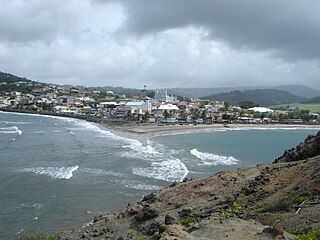
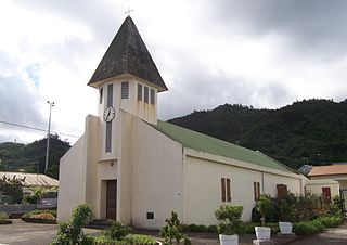
Sainte-Marie is a town and the fifth-largest commune in the French overseas department of Martinique. It is located on the northeast side of the island of Martinique.

<span class="mw-page-title-main">Le Tampon</span> Commune in Réunion

Le Tampon is the fourth-largest commune in the French overseas department and region of Réunion. It is located on the south-central part of the island of Réunion, adjacent to Saint Pierre.

<span class="mw-page-title-main">Saint-Joseph, Réunion</span> Commune in Réunion, France

Saint-Joseph is a commune in the French overseas department of Réunion. It is located on the extreme south end of the island of Réunion. As such, it features the southernmost point of the European Union. The village Vincendo is part of the commune.

<span class="mw-page-title-main">Sainte-Marie, Réunion</span> Commune in Réunion, France

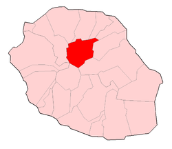
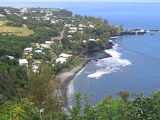
Sainte-Marie is a commune in the French overseas department of Réunion. It is located on the north side of the island of Réunion, just east of, and adjacent to, the capital of Saint-Denis.

<span class="mw-page-title-main">Saint-Leu, Réunion</span> Commune in Réunion, France

Saint-Leu is a commune in the French overseas department of Réunion. It is located on the west coast of the island of Réunion.

<span class="mw-page-title-main">La Possession</span> Commune in Réunion, France

La Possession is a commune in the French overseas department of Réunion. It is located in the northwestern part of the island of Réunion, between the capital of Saint-Denis and the commune of Le Port.

<span class="mw-page-title-main">La Plaine-des-Palmistes</span> Commune in Réunion, France

La Plaine-des-Palmistes is a commune in the French overseas department of Réunion.

<span class="mw-page-title-main">Les Avirons</span> Commune in Réunion, France

Les Avirons, is a commune in the Réunion overseas department of France in the Indian Ocean. It borders the communes of Saint-Leu, Cilaos, Saint-Louis and L'Étang-Salé, and 150 metres of coastline.

<span class="mw-page-title-main">Bras-Panon</span> Commune in Réunion, France

Bras-Panon is a commune on the Indian Ocean island of Réunion, which is an overseas department and region of France. Bras-Panon borders the communes of Saint-André, Saint-Benoît and Salazie; as well as the Mât river, the Rivière des Roches and the Indian Ocean.

<span class="mw-page-title-main">Sainte-Suzanne, Réunion</span> Commune in Réunion, France

Sainte-Suzanne is a commune on the north coast of the French island and department of Réunion, an island located approximately 950 km east of the island of Madagascar.

<span class="mw-page-title-main">Saint-Philippe</span> Commune in Réunion, France

Saint-Philippe is a commune in the French overseas department of Réunion. It is located in southeastern Reunion.

<span class="mw-page-title-main">Saint-Martial, Gard</span> Commune in Occitania, France

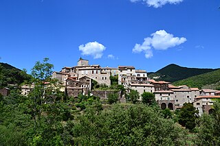
Saint-Martial is a commune in the Gard department in southern France.

<span class="mw-page-title-main">Sainte-Marie-de-Cuines</span> Commune in Auvergne-Rhône-Alpes, France

Sainte-Marie-de-Cuines is a commune in the Savoie department in the Auvergne-Rhône-Alpes region in south-eastern France.

<span class="mw-page-title-main">Saint-Maurice-aux-Forges</span> Commune in Grand Est, France

Saint-Maurice-aux-Forges is a commune in the Meurthe-et-Moselle department in north-eastern France.

<span class="mw-page-title-main">Sainte-Gemme-la-Plaine</span> Commune in Pays de la Loire, France

Sainte-Gemme-la-Plaine is a commune in the Vendée department in the Pays de la Loire region in western France.

<span class="mw-page-title-main">Saint-André, Réunion</span> Commune in Réunion, France

Saint-André is the fifth-largest commune in the French overseas department of Réunion. It is located on the northeast part of the island of Réunion. The small lake Étang de Bois Rouge is located in the commune.

<span class="mw-page-title-main">Les Belleville</span> Commune in Auvergne-Rhône-Alpes, France

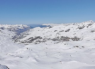
Les Belleville is a commune in the Savoie department of southeastern France. The municipality was established on 1 January 2016 by the merger of the former communes of Saint-Martin-de-Belleville and Villarlurin. On 1 January 2019, the former commune Saint-Jean-de-Belleville was merged into Les Belleville.

<span class="mw-page-title-main">Valromey-sur-Séran</span> Commune in Auvergne-Rhône-Alpes, France

Valromey-sur-Séran is a commune in the Ain department in eastern France. The municipality was established on 1 January 2019 by merger of the former communes of Belmont-Luthézieu, Lompnieu, Sutrieu and Vieu.

References

  1. "Répertoire national des élus: les maires" (in French). data.gouv.fr, Plateforme ouverte des données publiques françaises. 30 November 2023.
  2. "Populations légales 2021". The National Institute of Statistics and Economic Studies. 28 December 2023.
  3. Presentation of Salazie (from Flags of the World (website), with references)
  4. "Fiche Climatologique Statistiques 1991-2020 et records" (PDF) (in French). Météo-France . Retrieved August 31, 2022.
  5. "Fiche Climatologique Statistiques 1991-2020 et records" (PDF) (in French). Météo-France . Retrieved August 29, 2022.
  6. Population en historique depuis 1968, INSEE