Salt Creek (Middle Fork Willamette River tributary)

Last updated
Salt Creek
Salt Creek Falls Area (Lane County, Oregon scenic images) (lanDA0037a).jpg
Salt Creek in the canyon below Salt Creek Falls
Name origin: Salt springs along the creek that attract deer [1]
Country United States
State Oregon
County Lane
Source Lower Betty Lake
 - location southeast of Waldo Lake
 - elevation 5,481 ft (1,671 m) [2]
 - coordinates 43°40′09″N122°01′17″W / 43.66917°N 122.02139°W / 43.66917; -122.02139   [3]
Mouth Middle Fork Willamette River
 - location just below Hills Creek Dam
 - elevation 1,225 ft (373 m) [2]
 - coordinates 43°43′31″N122°26′16″W / 43.72528°N 122.43778°W / 43.72528; -122.43778 Coordinates: 43°43′31″N122°26′16″W / 43.72528°N 122.43778°W / 43.72528; -122.43778   [3]
Length 30 mi (48 km) [4]

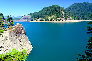
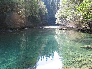
Salt Creek is a tributary, 30 miles (48 km) long, of the Middle Fork Willamette River in Lane County in the U.S. state of Oregon. [1] [3] [4] It is named for salt springs along its banks that are used as licks by deer. [1] [5] The stream originates as an outflow of Lower Betty Lake in the forested Cascade Range just southeast of Waldo Lake. From its source, Salt Creek flows generally south, through Gold Lake, to Route 58, which it then follows mainly northwest for about 26 miles (42 km) to its mouth at the Middle Fork Willamette River just below Hills Creek Dam. [6] [7] [8] At Salt Creek Falls—roughly 4 miles (6.4 km) west of Willamette Pass and a little more than 22 miles (35 km) upstream from the mouth [7] [9] —the stream plunges 286 feet (87 m), [10] discharging an average of 50,000 U.S. gallons (190,000 L) of water per minute, or 111 cubic feet per second (3.1 m3/s). [11] Below the falls, the creek enters a narrow canyon shaped by glaciation and basalt lava flows from higher in the Cascades. [9] [12] McCredie Hot Springs, at the former community of McCredie Springs, are natural hot springs along the lower half of Salt Creek beside Route 58. [13] [14]

Middle Fork Willamette River river in the United States of America

The Middle Fork Willamette River is one of several forks that unite to form the Willamette River in the western part of the U.S. state of Oregon. It is approximately 115 miles (185 km) long, draining an area of the Cascade Range southeast of Eugene, which is at the southern end of the Willamette Valley.

Lane County, Oregon county in Oregon, USA

Lane County is a county in the U.S. state of Oregon. As of the 2010 census, the population was 351,715, making it the fourth-most populous county in Oregon. The county seat is Eugene. It is named in honor of Joseph Lane, Oregon's first territorial governor.

United States federal republic in North America

The United States of America (USA), commonly known as the United States or America, is a country composed of 50 states, a federal district, five major self-governing territories, and various possessions. At 3.8 million square miles, the United States is the world's third or fourth largest country by total area and is slightly smaller than the entire continent of Europe's 3.9 million square miles. With a population of over 327 million people, the U.S. is the third most populous country. The capital is Washington, D.C., and the largest city by population is New York City. Forty-eight states and the capital's federal district are contiguous in North America between Canada and Mexico. The State of Alaska is in the northwest corner of North America, bordered by Canada to the east and across the Bering Strait from Russia to the west. The State of Hawaii is an archipelago in the mid-Pacific Ocean. The U.S. territories are scattered about the Pacific Ocean and the Caribbean Sea, stretching across nine official time zones. The extremely diverse geography, climate, and wildlife of the United States make it one of the world's 18 megadiverse countries.

The Salt Creek watershed is a temperate coniferous forest in which the primary tree species include Douglas fir, western hemlock, and mountain hemlock. [15] [16] [17] Fish species in Salt Creek are primarily trout, [18] especially coastal cutthroat trout, rainbow trout, and non-native brook trout. [19] The brook trout were introduced into lakes in and around the Salt Creek watershed, and many now live in upper Salt Creek. Bull trout formerly inhabited Salt Creek until damage to habitat throughout the Willamette River basin, such as the construction of dams, reduced and eliminated some populations in the Willamette's watershed. [20]

Temperate coniferous forest biome

Temperate coniferous forest is a terrestrial habitat type defined by the World Wide Fund for Nature. Temperate coniferous forests are found predominantly in areas with warm summers and cool winters, and vary in their kinds of plant life. In some, needleleaf trees dominate, while others are home primarily to broadleaf evergreen trees or a mix of both tree types. A separate habitat type, the tropical coniferous forests, occurs in more tropical climates.

Douglas fir species of tree

Pseudotsuga menziesii is an evergreen conifer species in the pine family, Pinaceae. It is native to western North America and is known as Douglas fir, Douglas-fir, Oregon pine, and Columbian pine. There are two varieties: coast Douglas-fir, and Rocky Mountain Douglas-fir.

<i>Tsuga heterophylla</i> species of plant

Tsuga heterophylla, the western hemlock or western hemlock-spruce, is a species of hemlock native to the west coast of North America, with its northwestern limit on the Kenai Peninsula, Alaska, and its southeastern limit in northern Sonoma County, California.

Related Research Articles

Deschutes River (Oregon) river in the United States of America

The Deschutes River in central Oregon is a major tributary of the Columbia River. The river provides much of the drainage on the eastern side of the Cascade Range in Oregon, gathering many of the tributaries that descend from the drier, eastern flank of the mountains. The Deschutes provided an important route to and from the Columbia for Native Americans for thousands of years, and then in the 19th century for pioneers on the Oregon Trail. The river flows mostly through rugged and arid country, and its valley provides a cultural heart for central Oregon. Today the river supplies water for irrigation and is popular in the summer for whitewater rafting and fishing.

Clackamas River tributary of the Willamette River in Oregon

The Clackamas River is an approximately 83-mile (134 km) tributary of the Willamette River in northwestern Oregon, in the United States. Draining an area of about 940 square miles (2,435 km2), the Clackamas flows through mostly forested and rugged mountainous terrain in its upper reaches, and passes agricultural and urban areas in its lower third. The river rises in eastern Marion County, about 55 miles (89 km) east-southeast of Salem. The headwaters are on the slopes of Olallie Butte in the Mount Hood National Forest, about 10 miles (16 km) north of Mount Jefferson, at an elevation of 4,909 feet (1,496 m) in the Cascade Range. The Clackamas flows briefly north and then flows northwest through the mountains, passing through North Fork Reservoir and Estacada. It then emerges from the mountains southeast of Portland. It joins the Willamette near Oregon City and forms the boundary between Oregon City and Gladstone.

McKenzie River (Oregon) tributary of the Willamette River in Oregon

The McKenzie River is a 90-mile (145 km) tributary of the Willamette River in western Oregon in the United States. It drains part of the Cascade Range east of Eugene and flows westward into the southernmost end of the Willamette Valley. It is named for Donald McKenzie, a Scottish Canadian fur trader who explored parts of the Pacific Northwest for the Pacific Fur Company in the early 19th century. As of the 21st century, six large dams have been built on the McKenzie and its tributaries.

Little River (North Umpqua River tributary) tributary of the North Umpqua River in Oregon, United States of America

The Little River is a tributary of the North Umpqua River, about 30 miles (48 km) long, in southwestern Oregon in the United States. It drains part of the western side of the Cascade Range east of Roseburg, between the North and South Umpqua.

Chewaucan River river in the United States of America

The Chewaucan River is part of the Great Basin drainage. It flows 53 miles (85 km) through the Fremont–Winema National Forests, Bureau of Land Management land, and private property in southern Oregon. Its watershed consists of 651 square miles (1,690 km2) of conifer forest, marsh, and rural pasture land. The river provides habitat for many species of wildlife including native Great Basin redband trout a subspecies of rainbow trout.

Blue River (Oregon) tributary of the McKenzie River in Linn and Lane counties in the U.S. state of Oregon

Blue River is a tributary of the McKenzie River in Linn and Lane counties in the U.S. state of Oregon. From its source at the confluence of Mann and Wolf creeks in the Cascade Range, it flows generally southwest to join the McKenzie near the community of Blue River. Saddle Dam and Blue River Dam block the river about 2 miles (3 km) from its mouth to form Blue River Reservoir, a multipurpose impoundment built in 1968 by the United States Army Corps of Engineers.

Cougar Reservoir

Cougar Reservoir is a reservoir on the South Fork McKenzie River in the U.S. state of Oregon. It is in Lane County, 46 miles (74 km) east of Eugene and about 3 miles (5 km) south of the community of Rainbow in the Willamette National Forest. In 1963 the United States Army Corps of Engineers built Cougar Dam on the river primarily to generate hydroelectricity and control flooding, and the reservoir formed behind the dam.

North Fork Clackamas River river in the United States of America

The North Fork Clackamas River is a tributary, about 11 miles (18 km) long, of the Clackamas River in the U.S. state of Oregon. Originating at nearly 4,000 feet (1,200 m) above sea level on the west side of the Cascade Range, it flows westward through Mount Hood National Forest. It joins the Clackamas at North Fork Reservoir, about 32 miles (51 km) from the larger river's confluence with the Willamette River. From source to mouth, the following tributaries enter the river: Dry Creek from the right bank, Boyer Creek from the left bank, then Whiskey, Bedford, Bee, and Fall creeks, all from the right.

Salt Creek Falls waterfall

Salt Creek Falls is a cascade and plunge waterfall on Salt Creek, a tributary of the Middle Fork Willamette River, that plunges into a gaping canyon near Willamette Pass in the Willamette National Forest, near Oakridge, Oregon. The waterfall is notable for its main drop of 286 feet (87 m) which makes it the third highest plunge waterfall in Oregon after Multnomah Falls and Watson Falls the second highest, which was re-measured in 2009 and found to be 293 feet rather than an earlier measurement of 272 feet passing Salt Creek Falls. The pool at the bottom of the waterfall is 20 metres (66 ft) deep.

Little Butte Creek river in the United States of America

Little Butte Creek is a 17-mile-long (27 km) tributary of the Rogue River in the U.S. state of Oregon. Its drainage basin consists of approximately 354 square miles (917 km2) of Jackson County and another 19 square miles (49 km2) of Klamath County. Its two forks, the North Fork and the South Fork, both begin high in the Cascade Range near Mount McLoughlin and Brown Mountain. They both flow generally west until they meet near Lake Creek. The main stem continues west, flowing through the communities of Brownsboro, Eagle Point, and White City, before finally emptying into the Rogue River about 3 miles (5 km) southwest of Eagle Point.

Big Butte Creek river in Oregon, United States of America

Big Butte Creek is a 12-mile-long (19 km) tributary of the Rogue River in the U.S. state of Oregon. It drains approximately 245 square miles (635 km2) of Jackson County. Its two forks, the North Fork and the South Fork, both begin high in the Cascade Range near Mount McLoughlin. Flowing predominantly west, they meet near the city of Butte Falls. The main stem flows generally northwest until it empties into the Rogue Falls was incorporated in 1911, and remains the only incorporated town within the watershed's boundaries.

Winchuck River river in the United States of America

The Winchuck River is a short coastal stream that runs through the Rogue River–Siskiyou National Forest to the Pacific Ocean in the U.S. states of Oregon and California. Flowing generally west from its origin near Elk Mountain, the river enters the sea at Crissey Field State Recreation Site, about 12 mile (0.80 km) north of the Oregon–California border and about 5 miles (8 km) south of Brookings.

South Fork Breitenbush River river in the United States of America

The South Fork Breitenbush River is a 10-mile (16 km) tributary of the Breitenbush River in the U.S. state of Oregon. The river flows generally northwest from Russell Lake in the Mount Jefferson Wilderness of the Cascade Range to near Breitenbush Hot Springs, where it merges with the North Fork Breitenbush River to form the main stem.

Elkhorn Creek (Marion County, Oregon)

Elkhorn Creek is a 7.6-mile (12 km) long stream in Marion County, Oregon, United States. Its source is on the northern edge of the Willamette National Forest, about 3.5 miles (5.6 km) north of Big Cliff Reservoir. The creek flows mostly west, receiving Big Twelve Creek, Buckhorn Creek, and Buck Creek all from the south, and it enters the Little North Santiam River just south of Elkhorn Woods Park, about 5 miles (8.0 km) north of the city of Gates. The stream's valley is surrounded by the western Cascade foothills, covered with coniferous trees characteristic of the Pacific Northwest, and lined with red alders at the water's edge. The creek supports runs of rainbow and coastal cutthroat trout, as well as Pacific giant salamanders. On September 30, 1996, a 6.4-mile (10.3 km) portion of the stream, from the mouth nearly to the source, was protected as part of the National Wild and Scenic Rivers System.

Yakso Falls

Yakso Falls is a 70-foot (21 m) waterfall on Little River, in the Cascade Range east of Roseburg in the U.S. state of Oregon. The waterfall is about 27 miles (43 km) from the unincorporated community of Glide along Little River Road, which becomes Forest Road 27.

South Fork McKenzie River tributary of the McKenzie River in Oregon

The South Fork McKenzie River is a tributary, about 31 miles (50 km) long, of the McKenzie River in the U.S. state of Oregon. It begins at about 4,500 feet (1,400 m) above sea level near Mink Lake in the Three Sisters Wilderness of the Cascade Range. Flowing northwest within Lane County, it meets the McKenzie River about 60 miles (97 km) from the larger river's confluence with the Willamette River.

Fall River (Oregon) river in Oregon, United States

The Fall River is a tributary of the Deschutes River in the Deschutes National Forest in Deschutes County, Oregon, United States. The source is a spring approximately 2 miles (3 km) northwest of Pringle Falls. The river flows to the northeast and is about 12 miles (19 km) long. Fly fishing is permitted.

Coldwater Lake (Washington) lake of the United States of America

Coldwater Lake is a barrier lake on the border of Cowlitz County and Skamania County, Washington in the United States. The lake was created during the 1980 eruption of Mount St. Helens, which blocked its natural outlet, Coldwater Creek, with volcanic debris. It is one of several lakes in the area that were created or otherwise enlarged by the eruption.

References

  1. 1 2 3 McArthur, Lewis A.; McArthur, Lewis L. (2003) [1928]. Oregon Geographic Names (7th ed.). Portland, Oregon: Oregon Historical Society Press. p. 843. ISBN   978-0875952772.
  2. 1 2 Source and mouth elevations derived from Google Earth search using GNIS coordinates.
  3. 1 2 3 "Salt Creek". Geographic Names Information System . United States Geological Survey. November 28, 1980. Retrieved February 17, 2014.
  4. 1 2 "National Hydrography Dataset". U.S. Geological Survey. Retrieved February 17, 2014.
  5. "Indians, Surveyors, Incidents Gave Names to Streams, Lakes and Mountains". Eugene Register-Guard . January 4, 1942. p. 5. Retrieved April 23, 2015.
  6. United States Geological Survey Topographic Map: Jo Ann Lake, Oregon, Quadrangle (Map). Cartography by U.S. Geological Survey. TopoQuest. Retrieved February 17, 2014.
  7. 1 2 Oregon (Map) (1993 ed.). 1:500,000. Cartography by Allan Cartography. Medford, Oregon: Raven Maps & Images. 1987. OCLC   41588689.
  8. United States Geological Survey Topographic Map: Lower Marilyn Lake, Oregon, Quadrangle (Map). Cartography by U.S. Geological Survey. TopoQuest. Retrieved February 17, 2014.
  9. 1 2 United States Geological Survey Topographic Map: Salt Creek Tunnel 2539, Oregon, Quadrangle (Map). Cartography by U.S. Geological Survey. TopoQuest. Retrieved February 17, 2014.
  10. "Salt Creek Falls Trail/Diamond Creek Falls Loop". U.S. Forest Service. Retrieved February 17, 2014.
  11. "Salt Creek Falls Observation Site". U.S. Forest Service. Retrieved February 17, 2014.
  12. "Salt Creek Falls: Lane County, Oregon". Northwest Waterfall Survey. July 27, 2011. Retrieved February 17, 2014.
  13. "McCredie Hot Springs". Geographic Names Information System . United States Geological Survey. May 22, 1986. Retrieved February 17, 2014.
  14. Richard, Terry (January 12, 2014). "Snow isn't essential to enjoy Willamette Pass in Oregon". The Herald. Everett, Washington. Retrieved February 17, 2014.
  15. Richardson, David M., ed. (1998). Ecology and Biogeography of Pinus (2000 ed.). New York, New York: Cambridge University Press. pp. 128–30. ISBN   0-521-78910-9. OCLC   43717786.
  16. "Subalpine Fir". U.S. Forest Service. Retrieved July 10, 2015.
  17. "Western Hemlock". U.S. Forest Service. Retrieved July 10, 2015.
  18. "Recreation Report: Willamette Zone: Fishing". Oregon Department of Fish and Wildlife. February 12, 2014. Retrieved February 17, 2014.
  19. "Middle Fork Willamette & Tributaries" (PDF). Oregon Department of Fish and Wildlife. Archived from the original (PDF) on February 22, 2014.
  20. "Chapter 5: Willamette River Recovery Unit" (PDF). U.S. Fish and Wildlife Service. pp. v–vii, 7, 17. Retrieved February 17, 2014.