San Juan Hot Springs

Last updated

San Juan Hot Springs
San Juan Capistrano Hot Springs
San Juan Creek Canyon, Orange County, California - 2023 November 01.jpg
Public access to San Juan Hot Springs has been restricted since approximately 1993
San Juan Hot Springs
Location Ortega Highway, Ronald W. Caspers Wilderness Park, Orange County, California, United States
Coordinates 33°35′27″N117°30′34″W / 33.5908°N 117.5095°W / 33.5908; -117.5095
Type geothermal
Discharge35 US gallons (130 L; 29 imp gal) per min
Temperature122 °F (50 °C)

San Juan Hot Springs, also San Juan Capistrano Hot Springs, is a geothermal area in what is now Ronald W. Caspers Wilderness Park, near Cleveland National Forest, in Orange County, California in the United States. The springs were used by the Indigenous peoples of the region, and were an integral part of the dominion of Misíon San Juan Capistrano. They were later developed and used, on and off for a hundred years, as a resort area of post-settlement Southern California. The 52 springs were designated Orange County Historic Landmark No. 38 in 1989.

Contents

History

Agua caliente and "Sierra del Agua Caliente" appear on the 1840s diseno for Rancho Mission Viejo Agua caliente on Rancho Mission Viejo 1840s.jpg
Agua caliente and "Sierra del Agua Caliente" appear on the 1840s diseño for Rancho Mission Viejo

According to Mission San Juan Capistrano's application for the National Register of Historic Places, "Published oral accounts indicate that a sizable Indian settlement was located near the springs." [1] The Acjachemen (Juaneño) village at the springs was called Paala Sáqqiwvna, and the springs have been tentatively associated with the name Palasakeuna, although this correlation is disputed and may apply instead to Murrieta Hot Springs. [2] According to U.S. government geologist Gerald A. Waring's report of 1915, the springs "were formerly visited by the Indians, who built mud huts ( temescals ), for use as vapor-bath chambers. The springs are mentioned in the records of the Franciscan friars, who visited them when in charge of the mission at San Juan Capistrano." [3] After the missionaries came, they built an adobe structure near the springs that was used as a sort of parsonage or mission annex. [1] An old-timer recalled the springs as they were in the 1870s, writing to the Los Angeles Times, "I have been familiar with these springs and their many benefits to mankind...since 1873 and can testify to the value of their mineral waters. Back in the seventies, there was a passable trail, and the wayfarer making a pilgrimage to the healthful shrine was sure of a friendly welcome from the native Indians that frequented the place, with their sick [and] lame..." [4] In oral history interviews done in the late 20th-century, Acjachemen people described their grandparents going to the hot springs area in the autumn to collect acorns for food. [5]

19th century

Landscape between San Juan Capistrano and Lake Elsinore Ortega Highway Between San Juan Capistrano and Lake Elsinore, California (5974112125).jpg
Landscape between San Juan Capistrano and Lake Elsinore
San Juan Hot Springs resort c. 1890 (Orange County Archives) Orange County Archives - San Juan Hot Springs, circa 1890.jpg
San Juan Hot Springs resort c.1890 (Orange County Archives)
B.F. Conaway photograph of campers at San Juan Hot Springs in 1891 (Cal State Fullerton Special Collections) B.F. Conaway photograph of campers at San Juan Hot Springs 1891.jpg
B.F. Conaway photograph of campers at San Juan Hot Springs in 1891 (Cal State Fullerton Special Collections)

The springs are located at about the halfway point on the route between the coast and Lake Elsinore. [6] During the early settlement era, the springs were owned by ranchero Juan Forster, who "blocked development at the site to ensure access to the waters by Indians and other poor local residents." [7] The land later became part of the O'Neill ranch and development began around 1885, when "two or three small buildings were constructed here, and the place also became a resort for campers as well as for the ailing". [3]

A California guidebook first published in 1888 described the San Juan Springs as an important, albeit remote, destination for tourists: [8]

For many years the San Juan hot springs have been noted for curing rheumatism and syphilis. They are sixty-five miles from Los Angeles, and there has been no railroad or hotel near them, yet people in great numbers are constantly making pilgrimages to this far-away place. There is no hotel, but the patients have tents or cheap houses to live in during their treatment. Mud baths are considered very efficacious, and, as there are no permanent buildings, these anxious seekers after health improvise mud bathing houses of a primitive type. There are over a dozen of these springs spread over an acre of ground, and another hot spring, known as McKnight's, a half-mile away. There are also cold springs near by...They are fourteen miles from San Juan-by-the-Sea. For the present, the best means to reach them is to San Juan-by-the-Sea by the California Central, and from there by team". [8]

After the railroad came through, a regular stage operation from the train station to the springs was established in 1889, and the following year a dance hall and boarding house opened. [7]

20th century to present

Map of route from San Juan Capistrano to Lake Elsinore, drawn 1914 by Orange County surveyor J. L. McBride for the Los Angeles Times Map from San Juan Capistrano to Lake Elsinore 1914.jpg
Map of route from San Juan Capistrano to Lake Elsinore, drawn 1914 by Orange County surveyor J. L. McBride for the Los Angeles Times

In 1907 a judge described the route: [9]

One rides from Capistrano in the valley of San Juan creek for twelve miles amid a great variety of hill and plain, forest and field, running waters, clear and cool, the stream being crossed several times (the sand and gravel beds at the crossings making the sole exception to a good road) and the valley gradually narrowing till reaching here, where the principal springs are in the northwest side at an elevation of fifty to sixty feet or more above the creek bed...High up the southeast hillside is a spring of mineral water similar in its constituents to the hot, but water very cold. [9]

Circa 1908, "improvements consisted of a small hotel, bathhouse, and three cottages. There are ample camp grounds, and the place has been used mainly as a camping resort". [3] The first resort built at the site burned in 1910. [10] By the 1920s, the resort had come into possession of one Leon Eyraud, at which time it was reportedly one of Orange County's most popular tourist destinations. [11] The owners advertised the local hikes, and trout fishing in the nearby stream, and stated that "tubercular and other objectionable cases" would not be admitted. [12] According to the Los Angeles Times per San Juan Capistrano historian Pamela Hallan-Gibson, "At one point, the springs had a large swimming pool and a store that sold wine, sandwiches and candy. People came from throughout Orange County for camping vacations that included card-playing, hunting and fishing." [7] But the resort closed during the Great Depression in 1936, possibly because of health code issues or health concerns like epidemic polio, and stayed closed for decades. [7] The dance hall from this era has been saved and was moved into town where it is used as a police substation. [13] In 1938 plans to either turn the site into a retreat for sick children or to add the area to Cleveland National Forest were stalled by cost issues; the Forest Service's estimate of the land value was half of what the owners of Rancho Santa Margarita wanted for it. [14]

San Juan Creek near the hot springs (2023) San Juan Creek Canyon, Orange County, California - 2023 November 02.jpg
San Juan Creek near the hot springs (2023)
Gray buckeye on an oak tree near the springs San Juan Creek Canyon, Orange County, California - 2023 November 04.jpg
Gray buckeye on an oak tree near the springs

Nonetheless, the site remained an attractive destination and in the 1960s "became notorious as a hangout for hippie bathers, who were often arrested for trespassing and indecent exposure". [15] A "commune" reportedly moved in, and in addition to public nudity, [16] there were two murders and quite a bit of drug use. [10] The Orange County Sheriff's Department was summoned on a regular basis. [17] The old masonry tubs were eventually dynamited to discourage squatters, [17] and the overflow re-routed to a ditch that drained into Hot Spring Creek (a tributary of San Juan Creek). [10] During this era there were continuing but always unsuccessful efforts to add the springs to Cleveland National Forest. [18] In 1974 the county put up a barricade around the springs to reduce visitor traffic, nudity, graffiti, etc. [19]

The springs were reopened to the public by a county franchisee in 1981. [19] In the 1980s the springs were said to be set in a grove of oaks, sycamore, and alder trees. [20] Redwood soaking tubs set into the hillside used 16 of an estimated 52 spring vents. [20] Rates were either hourly ($6.50 to $7.50 an hour, depending on the size of the tub), or daily, and the hot springs were open 24 hours, with a separate night rental fee. [20] (It was $12.50 a day for overnight rental of a full-size teepee. [17] ) In 1989 the springs were designated an Orange County historic landmark. [15]

San Juan Creek watershed San Juan Creek map-01.png
San Juan Creek watershed

The 17-acre (6.9 ha; 0.027 sq mi) resort shut down in 1992. [7] According to the vendor who operated the resort, "When Caltrans in 1990 removed more than 100 trees, including 13 oaks and numerous sycamores and eucalyptus, to expand a bridge over Hot Spring Creek on Ortega Highway, it destroyed the ambience of the secluded hot springs." [7] The county had also recently increased the monthly lease payment, there was a recession, and according to one official, consumer fears about AIDS transmission may have contributed to the resort's struggles. [7] The 1993 Ortega Fire destroyed most of the amenities that had been built at the site. [18]

The springs are now fenced off with barbed wire, but there is a picnic area across San Juan Creek that serves as a respite spot for hikers. [18] Access from Ortega Highway has been blocked with gates, but there is a 13-mile (21 km) round-trip hike from the park entrance that routes past the springs. [21] The gates are opened for rare naturalist-guided tours that are listed on the OCparks.com events calendar. [18]

California sycamore that likely survived the 1993 wildfire San Juan Creek Canyon, Orange County, California - 2023 November 03.jpg
California sycamore that likely survived the 1993 wildfire

Water profile

"The Best Health Resort in California" (The Register, October 5, 1920) The Best Health Resort in California.jpg
"The Best Health Resort in California" (The Register, October 5, 1920)

A 1888 California book reported the temperature of the hot springs was 135 °F (57 °C). [8]

Per Waring in 1915, the water issues "from granitic rocks and near the base of the steeper slopes of a portion of the coastal ranges. Two main springs, four minor ones, and several marshy patches are here situated on the western side of the canyon on slopes near the creek. The highest temperature recorded was 124 °F (51 °C), along with a discharge rate of 35 US gallons (130 L; 29 imp gal) a minute. Other warm springs issue in a canyon half a mile westward. The water is slightly sulphureted, but, like the other hot waters of this region, it is not highly mineralized. The analysis indicates a slightly mineralized soft water, primary alkaline saline in character." [3]

In 1980, NOAA measured the temperature at 120 °F (49 °C), [22] That temperature held steady, as in 1992, the water was reported to be 120 °F (49 °C) upon emergence and flow at 50 US gallons (190 L; 42 imp gal) a minute. [7]

See also

Related Research Articles

<span class="mw-page-title-main">Mission San Juan Capistrano</span> 18th-century Spanish mission in California

Mission San Juan Capistrano is a Spanish mission in San Juan Capistrano, Orange County, California. Founded November 1, 1776 in colonial Las Californias by Spanish Catholic missionaries of the Franciscan Order, it was named for Saint John of Capistrano. The Spanish Colonial Baroque style church was located in the Alta California province of the Viceroyalty of New Spain. The Mission was founded less than 60 yards from the village of Acjacheme. The Mission was secularized by the Mexican government in 1833, and returned to the Roman Catholic Church by the United States government in 1865. The Mission was damaged over the years by a number of natural disasters, but restoration and renovation efforts date from around 1910. It functions today as a museum.

<span class="mw-page-title-main">San Juan Capistrano, California</span> City in California, United States

San Juan Capistrano is a city in southern Orange County, California, United States. The population was 35,253 at the 2020 Census.

Putuidem, alternative spelling Putiidhem or Putuidhem, was a large native village of the Acjachemen people, also known as Juaneño since their relocation to Mission San Juan Capistrano. Putuidem was a mother village, a community that spawned other villages of the tribe.

<span class="mw-page-title-main">Orange County Line</span> Metrolink commuter rail line linking Downtown Los Angeles to Orange County and Oceanside

The Orange County Line is a commuter rail line run by Metrolink from Los Angeles through Orange County to Oceanside in San Diego County, connecting with the Coaster commuter rail service to San Diego. The Orange County Line carries passengers to the primary Metrolink hub at L.A. Union Station in downtown Los Angeles, as well as to many attractions in Orange County including the Knott's Berry Farm area, Angel Stadium of Anaheim and the Honda Center, the Disneyland Resort, Old Town Orange, Santa Ana Zoo, Mission San Juan Capistrano and many more. In San Diego County, it serves the Oceanside Pier and Camp Pendelton.

<span class="mw-page-title-main">Doheny State Beach</span> State park in California, United States

Doheny State Beach is known as the first state beach in the California state park system. Located on the Pacific Ocean in the city of Dana Point, the beach is adjacent to several surf spots and scenic beaches including Salt Creek Beach, Baby Beach, and Capistrano Beach. Along with its neighbors, Doheny beach is a popular surf spot located at the mouth of San Juan Creek, which flows from the Santa Ana Mountains southwest to the beach, where it forms a fresh-water lagoon.

JSerra Catholic High School is a private coeducational Catholic high school located in San Juan Capistrano, California. Named after Saint Junípero Serra, the school was founded by parents in 2003 and is an independent school sanctioned by the Diocese of Orange. Total enrollment as of 2015 was 1,225.

<span class="mw-page-title-main">Acjachemen</span> Native American people in California

The Acjachemen are an Indigenous people of California. Published maps often identify their ancestral lands as extending from the beach to the mountains, south from what is now known as Aliso Creek in Orange County to the Las Pulgas Canyon in the northwestern part of San Diego County. However, sources also show that Acjachemen people shared sites with other indigenous nations as far north as Puvunga in contemporary Long Beach.

<span class="mw-page-title-main">San Juan Creek</span> River in Orange County, California, United States

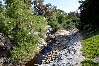
San Juan Creek, also called the San Juan River, is a 29-mile (47 km) long stream in Orange and Riverside Counties, draining a watershed of 133.9 square miles (347 km2). Its mainstem begins in the southern Santa Ana Mountains in the Cleveland National Forest. It winds west and south through San Juan Canyon, and is joined by Arroyo Trabuco as it passes through San Juan Capistrano. It flows into the Pacific Ocean at Doheny State Beach. State Route 74, the Ortega Highway, crosses the Santa Ana Mountains via San Juan Canyon.

<span class="mw-page-title-main">Aliso Creek (Orange County)</span> River in the United States of America

Aliso Creek is a 19.8-mile (31.9 km)-long, mostly urban stream in south Orange County, California. Originating in the Cleveland National Forest in the Santa Ana Mountains, it flows generally southwest and empties into the Pacific Ocean at Laguna Beach. The creek's watershed drains 34.9 square miles (90 km2), and it is joined by seven main tributaries. As of 2018, the watershed had a population of 144,000 divided among seven incorporated cities.

<span class="mw-page-title-main">Los Encinos State Historic Park</span> State park in Los Angeles County

Los Encinos State Historic Park is a state park unit of California, preserving buildings of Rancho Los Encinos. The park is located near the corner of Balboa and Ventura Boulevards in Encino, California, in the San Fernando Valley. The rancho includes the original nine-room de la Ossa Adobe, the two-story limestone Garnier building, a blacksmith shop, a natural spring, and a pond. The 4.7-acre (1.9 ha) site was established as a California state park in 1949.

<span class="mw-page-title-main">Arroyo Trabuco</span> Major tributary of San Juan Creek in Orange County, California

Arroyo Trabuco is a 22-mile (35 km)-long stream in coastal southern California in the United States. Rising in a rugged canyon in the Santa Ana Mountains of Orange County, the creek flows west and southwest before emptying into San Juan Creek in the city of San Juan Capistrano. Arroyo Trabuco's watershed drains 54 square miles (140 km2) of hilly, semi-arid land and lies mostly in Orange County, with a small portion extending northward into Riverside County. The lower section of the creek flows through three incorporated cities and is moderately polluted by urban and agricultural runoff.

<span class="mw-page-title-main">Santiago Creek</span> River in California, United States

Santiago Creek is a major watercourse in Orange County in the U.S. state of California. About 34 miles (55 km) long, it drains most of the northern Santa Ana Mountains and is a tributary to the Santa Ana River. It is one of the longest watercourses entirely within the county. The creek shares its name with Santiago Peak, at 5,687 ft (1,733 m) the highest point in Orange County, on whose slopes its headwaters rise.

<span class="mw-page-title-main">Sulphur Creek (California)</span> Creek in California, United States

Sulphur Creek is an approximately 4.5-mile (7.2 km) tributary of Aliso Creek in Orange County, California. The creek drains about 6 square miles (16 km2) in the suburban cities of Laguna Niguel and Laguna Hills. Although most of its watershed has been utilized for master planned residential development, the creek retains a natural channel with riparian and wetland habitat in parts of Laguna Niguel Regional Park and Aliso and Wood Canyons Regional Park. Urban runoff has changed the once seasonal creek into a perennial stream.

<span class="mw-page-title-main">Bell Canyon</span> River in California, USA

Bell Canyon is a major drainage of the Santa Ana Mountains in Orange County, California in the United States. Bell Creek flows about 14.4 miles (23.2 km) in a southerly direction to its confluence with San Juan Creek. The Bell Canyon drainage is located to the east and parallel to Cañada Gobernadora, and to the south of Trabuco Creek. After Trabuco Creek, it is the second largest tributary of San Juan Creek in terms of length and its watershed area of 26 square miles (67 km2).

<span class="mw-page-title-main">Gilman Hot Springs</span> Thermal springs in California

Gilman Hot Springs, also known as San Jacinto Hot Springs or the Relief Springs, is a hot spring system in the Inland Empire area of Southern California. Located near Potrero Creek, the San Jacinto River, and California State Route 79, the springs system consists of "about half a dozen" springs named for the Mexican land grant Rancho San Jacinto Viejo.

<span class="mw-page-title-main">Alume</span> Former Acjachemen village in California

Alume was a large Acjachemen village located between Trabuco Creek and Tijeras Creek at Rancho Santa Margarita, California. The village was also recorded as Alaugna and as El Trabuco in San Juan Capistrano mission records, and is also referred to as Alauna, Aluna, and Alona.

<span class="mw-page-title-main">Piwiva</span> Former Acjachemen village in Rancho Mission Viejo, California

Piwiva was a Acjachemen village located at the meeting place of the San Juan Creek and Cañada Gobernadora tributary in what is now Rancho Mission Viejo, California. The name for the village was closely related to the Payómkawichum word for wild tobacco piivat. It was located north of Mission San Juan Capistrano, downstream from the village of Huumai and upstream from the village of Sajavit. Alternative names for the village include Pii'iv, Pivits, and Peviva.

<span class="mw-page-title-main">Acjacheme</span> Former Acjachemen village at Mission San Juan Capistrano

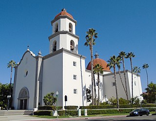
Acjacheme was an Acjachemen village that was closely situated to the mother village of Putuidem in what is now San Juan Capistrano, California. The Spanish missionaries constructed Mission San Juan Capistrano less than 60 yards from the village in 1776. Acjachemen is a pluralization of the word Acjacheme, and became the moniker for the people overall after the mission period.

<span class="mw-page-title-main">Fairview Hot Springs</span> Resort and well in California, U.S. (~1887–~1918)

Fairview Hot Springs was a resort hotel in Fairview, California, United States from about 1887 to about 1918. The source of the water that constituted the "hot springs" was actually a well that yielded a combination of heated artesian water and natural gas. The Fairview Hot Springs was known for its mudbaths, but the Fairview development was already languishing, when—due to either financial failure generally, or the 1918 San Jacinto earthquake specifically—the resort hotel closed its doors for good around 1918.

<span class="mw-page-title-main">Soboba Hot Springs</span> Geothermal site in California

Soboba Hot Springs are a historic hot springs and resort in Riverside County, California, United States. The springs issued from the side of a steep ravine "with narrow, precipitous sides, and the rock exposed is largely a crushed gneiss...the thermal character of the springs is due to crushing and slipping of the rocks". The Soboba Hot Springs resort was adjacent to the reservation of the Soboba Band of Luiseño Indians. Soboba means hot water in the Luiseño language.

References

  1. 1 2 "NHRP: Mission San Juan Capistrano". nps.gov. September 7, 1971. Retrieved 2023-11-10.
  2. O'Neil, Stephen; Evans, Nancy H. (1980). "Notes on Historical Juaneño Villages and Geographical Features". Journal of California and Great Basin Anthropology. 2 (2): 226–232. ISSN   0191-3557. JSTOR   27825028.
  3. 1 2 3 4 Waring, Gerald Ashley (January 1915). Springs of California. U.S. Department of the Interior, Geological Survey Water-Supply Papers. U.S. Government Printing Office. pp. 45–46. Water Supply Paper No. 338–339. Retrieved 2023-11-11 via HathiTrust.
  4. "He Can Remember". Letters to the Editor. The Los Angeles Times. October 21, 1937. p. 35. Retrieved 2023-11-13.
  5. Lobo, Frank P.; Lobo, Susan; Lobo, Kelina N. T. (2005). "Oral Histories with the Acjachemem of San Juan Capistrano". Journal of the Southwest. 47 (1): 29–46. ISSN   0894-8410. JSTOR   40170348.
  6. "Where Workers Will Shorten Route to Coast". Lake Elsinore Valley Sun-Tribune. May 16, 1929. p. 12. Retrieved 2023-11-13.
  7. 1 2 3 4 5 6 7 8 Hall, Len; Pinsky, Mark I. (February 22, 1992). "Hard Times Put San Juan Springs Out of Business : Resort: Historic hot-water spa is no longer profitable, owner says. The county hopes to find another operator". Los Angeles Times. Retrieved 2023-11-12.
  8. 1 2 3 Lindley, Walter; Widney, Joseph Pomeroy (1896) [1888]. California of the South: Its Physical Geography, Climate, Mineral Springs, Resources, Routes of Travel And Health-resorts, Being a Complete Guide-book to Southern California (3rd ed.). New York: D. Appleton. pp. 184–185. hdl:2027/nnc1.cu01636065 . Retrieved 2023-11-13 via HathiTrust.
  9. 1 2 "A Beauty Spot of Orange County". The Register. June 5, 1907. p. 7. Retrieved 2023-11-13.
  10. 1 2 3 "San Juan Hot Springs Re-Visited". Sun Post News. July 28, 1975. p. 7. Retrieved 2023-11-13.
  11. Hallan-Gibson, Pamela; Tryon, Don; Tryon, Mary Ellen (2005). San Juan Capistrano. Arcadia Publishing. ISBN   978-0-7385-3044-4.
  12. Epting, Chris (2008). Vanishing Orange County. Arcadia Publishing. ISBN   978-0-7385-5974-2.
  13. "San Juan Hot Springs - Orange County Outdoors". www.orangecountyoutdoors.com. Retrieved 2023-11-13.
  14. "Cost Balls Health Plan". The Los Angeles Times. February 17, 1938. p. 14. Retrieved 2023-11-13.
  15. 1 2 Archives, L. A. Times (October 14, 1989). "SADDLEBACK / SOUTH BEACH : SAN JUAN CAPISTRANO : Hot Springs to Be Historical Landmark". Los Angeles Times. Retrieved 2023-11-12.
  16. "Conversion of Wilderness Tract to Prestige Subdivision Proposed". The Los Angeles Times. November 10, 1974. p. 103. Retrieved 2023-11-13.
  17. 1 2 3 "San Juan Capistrano Hot Springs bubbles with visitors day and night". The Palm Beach Post. February 18, 1990. p. 112. Retrieved 2023-11-13.
  18. 1 2 3 4 Klein, Karin (October 4, 2010). Explorer's Guide 50 Hikes in Orange County (Explorer's 50 Hikes). The Countryman Press. ISBN   978-1-58157-859-1.
  19. 1 2 "HOT: Orange County's Natural Springs". The Los Angeles Times. February 3, 1985. p. 127. Retrieved 2023-11-13.
  20. 1 2 3 Sammon, John W. (January 1986). "Wellsprings of Health". Orange Coast . Emmis Communications. pp. 142–144. ISSN   0279-0483 . Retrieved 2023-11-11.
  21. Schad, Jerry; Harris, David Money (January 13, 2015). Afoot and Afield: Orange County: A Comprehensive Hiking Guide. Wilderness Press. ISBN   978-0-89997-757-7.
  22. Berry, George W.; Grim, Paul J.; Ikelman, Joy A. (1980). Thermal Spring List for the United States. Boulder, Colorardo: National Oceanic and Atmospheric Administration.