Santa Ana Peak

Last updated
Santa Ana Peak
Santa Ana Peak.jpg
West aspect
Highest point
Elevation 4,764 ft (1,452 m) [1]
Prominence 1,004 ft (306 m) [2]
Parent peak Peak 4755 [3]
Isolation 1.61 mi (2.59 km) [3]
Coordinates 60°05′02″N149°12′10″W / 60.0839982°N 149.2028277°W / 60.0839982; -149.2028277 [1]
Geography
Relief map of USA Alaska.png
Red triangle with thick white border.svg
Santa Ana Peak
Location of Santa Ana Peak in Alaska
CountryUnited States
State Alaska
Borough Kenai Peninsula
Protected area Alaska Department of Natural Resources [1]
Parent range Kenai Mountains [2]
Topo map USGS Seward A-6

Santa Ana Peak is a 4,764-foot-elevation (1,452-meter) mountain summit in Alaska, United States.

Contents

Description

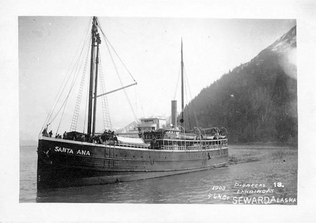
Santa Ana Peak is located eight miles (13 km) east of Seward in the Kenai Mountains, on land managed by the Alaska Department of Natural Resources. Precipitation runoff and glacial meltwater from the mountain drains west to Resurrection Bay via Fourth of July Creek and from the east slope to Day Harbor. Topographic relief is significant as the summit rises over 3,700 feet (1,128 m) above the creek in less than two miles (3.2 km) and 4,764 feet (1,452 m) above tidewater of the harbor in four miles (6.4 km). The mountain's toponym was officially adopted June 13, 2019, by the United States Board on Geographic Names. [1] The mountain is named for the wooden steamship Santa Ana which brought Seward's founders to this area in 1903. [1]

Santa Ana Peak to the left Anchorage to Seward - Seward area (5857544802).jpg
Santa Ana Peak to the left

Climate

Based on the Köppen climate classification, Santa Ana Peak is located in a tundra climate zone with long, cold, snowy winters, and mild summers. [4] Weather systems coming off the Gulf of Alaska are forced upwards by the Kenai Mountains (orographic lift), causing heavy precipitation in the form of rainfall and snowfall. Winter temperatures can drop below 0 °F with wind chill factors below −10 °F. This climate supports the Godwin Glacier to the north and smaller unnamed glaciers on the slopes of the peak.

See also

Related Research Articles

<span class="mw-page-title-main">Harding Icefield</span> Ice field in Alaska, United States

The Harding Icefield is an expansive icefield located in the Kenai Mountains of the Kenai Peninsula in Alaska. It is also partially located in Kenai Fjords National Park. It is named for U.S. President Warren G. Harding.

<span class="mw-page-title-main">Mount Alice (Alaska)</span> Mountain summit in Alaska, US

Mount Alice is a 5,318-foot (1,621 m) mountain summit located in the Kenai Mountains, in the U.S. state of Alaska. The peak is situated in Chugach National Forest, rising one vertical mile above the Resurrection River and Resurrection Bay, and 6.2 mi (10 km) northeast of Seward, Alaska, from where it appears as the most prominent peak on the skyline. The mountain's name was officially adopted in 1983 by the United States Geological Survey to honor Alice Lowell Scheffler (1879–1965), the daughter of Franklin G. Lowell, who with his family were the first homesteaders to settle the Seward area in 1883.

<span class="mw-page-title-main">Mount Benson (Alaska)</span> Mountain in the state of Alaska

Mount Benson is a 4,465-foot (1,361 m) mountain summit located in the Kenai Mountains, on the Kenai Peninsula, in the U.S. state of Alaska. The peak is situated in Chugach National Forest, rising above the Resurrection River and Resurrection Bay, 3.3 mi (5 km) south of Resurrection Peaks, 2.35 mi (4 km) north of Marathon Mountain, and 3.1 mi (5 km) northwest of Seward, Alaska. Originally named Iron Mountain, the mountain's name was officially changed in 1974 by the United States Geological Survey to honor Benny Benson (1913-1972), who at age 13 designed Alaska's flag in 1927, as a student in Seward.

<span class="mw-page-title-main">Resurrection Peaks</span> Mountain ridge in the state of Alaska

Resurrection Peaks is a 4,727-foot (1,441 m) mountain ridge located in the Kenai Mountains, on the Kenai Peninsula, in the U.S. state of Alaska. The peaks are situated in Chugach National Forest, 3.3 mi (5 km) north of Mount Benson, 3.5 mi (6 km) south of Mount Ascension, and 5 mi (8 km) north of Seward, Alaska. These peaks, marked 4712' and 4665' on the USGS map, together with their ridges and glacier form a distinct group. The peaks overlook the mouth of Resurrection River into Resurrection Bay, and take their name from the bay named since 1792, and the river since 1898. Resurrection Peaks' name was officially adopted in 1969 by the United States Geological Survey.

<span class="mw-page-title-main">Maynard Mountain</span> Mountain in Alaska

Maynard Mountain is a 4,137-foot (1,261 m) mountain summit located in the Chugach Mountains, in the U.S. state of Alaska. The peak is situated in Chugach National Forest, 3 mi (5 km) northwest of Whittier, Alaska, at the isthmus of the Kenai Peninsula, where the Chugach Mountains meet the Kenai Mountains. Nearby peaks include Bard Peak, 4.14 mi (7 km) to the south, and Begich Peak, 3.1 mi (5 km) to the west-northwest. Although modest in elevation, relief is significant since the eastern aspect of the mountain rises up from the tidewater of Prince William Sound's Passage Canal in approximately one mile. Maynard Mountain is often seen and photographed in the background behind Portage Lake, a popular tourist and recreation destination. The Anton Anderson Memorial Tunnel, often called the Whittier Tunnel, is a dual-use highway and railroad tunnel that passes through Maynard Mountain. With a length of 13,300 feet, it is the second-longest highway tunnel and longest combined rail and highway tunnel in North America.

<span class="mw-page-title-main">Phoenix Peak (Alaska)</span> Mountain in the state of Alaska

Phoenix Peak is a 5,187-foot (1,581 m) mountain summit located in the Kenai Mountains, on the Kenai Peninsula, in the U.S. state of Alaska. The peak is situated in Kenai Fjords National Park, 2 mi (3 km) southwest of Mount Benson, 1.1 mi (2 km) northwest of Marathon Mountain, and 3.5 mi (6 km) west of Seward, Alaska. The first ascent of the peak was made July 23, 1964, by Don Stockard of the Mountaineering Club of Alaska. The peak was named in 1965 by the Mountaineering Club of Alaska for the first ship ever built in Russian America, the Phoenix, which was constructed in 1794 by Russians in nearby Resurrection Bay. The mountain's name was officially adopted in 1966 by the United States Geological Survey.

<span class="mw-page-title-main">Mount Adair</span> Mountain in the state of Alaska

Mount Adair is a prominent 5,178-foot (1,578 m) double summit mountain located in the Kenai Mountains, on the Kenai Peninsula, in the U.S. state of Alaska. The east summit is higher than the 4,940-foot west peak. The mountain is situated in Chugach National Forest, 6.8 mi (11 km) north of Mount Ascension, 7.2 mi (12 km) west of Andy Simons Mountain, and 17 mi (27 km) north of Seward, Alaska. Precipitation runoff from the mountain drains into Kenai Lake. Mount Adair's local name was reported in 1951 by the U.S. Geological Survey.

<span class="mw-page-title-main">Andy Simons Mountain</span> Double summit mountain in Alaska, United States

Andy Simons Mountain is a prominent 6,407-foot (1,953 m) double summit mountain located in the Kenai Mountains, and the fourth-highest peak on the Kenai Peninsula in the state of Alaska. The true summit is 1.3 mile west of the 5,300+ foot subsidiary east peak on this five-mile-long northwest-to-southeast trending mountain. The mountain is situated in Chugach National Forest, 7.2 mi (12 km) east of Mount Adair, and 17 mi (27 km) north of Seward, Alaska. The Seward Highway and Alaska Railroad traverse its western foot. Precipitation runoff from the mountain drains into Kenai Lake.

<span class="mw-page-title-main">Cecil Rhode Mountain</span>

Cecil Rhode Mountain is a 4,400-foot (1,341 m) mountain summit located in the Kenai Mountains, on the Kenai Peninsula in the state of Alaska. The mountain is situated in Chugach National Forest, 50 mi (80 km) south of Anchorage, and 1.7 mi (3 km) south of Cooper Landing, Alaska. This peak is shown on maps as Cooper Benchmark, the northernmost peak on a ridge which includes Stetson Benchmark (4,576-ft), and Peak 4593. The mountain was named for Cecil E. Rhode (1902–1979), director of the Izaak Walton League, wildlife photographer, and writer who lived in Cooper Landing for 42 years and was best known for bringing wide exposure to the public about the wilds of Alaska, particularly in magazines such as National Geographic, Sports Afield, and Outdoor Life. The mountain's toponym was officially adopted August 13, 1981, by the United States Board on Geographic Names. Precipitation runoff from the mountain drains into the Kenai River.

<span class="mw-page-title-main">Bear Mountain (Seward, Alaska)</span> Mountain in Alaska, United States

Bear Mountain is a 4,019-foot (1,225 m) mountain summit located in the Kenai Mountains, on the Kenai Peninsula, in the U.S. state of Alaska. The peak is situated in Chugach National Forest, 5 mi (8 km) northeast of Bear Glacier, 2.1 mi (3 km) south-southeast of Marathon Mountain, and 5 mi (8 km) southwest of Seward, Alaska. The peak's local name was reported in 1951 by the U.S. Geological Survey. The months May and June offer the most favorable weather for viewing the mountain. In fair weather, the Harding Icefield can be seen from the summit.

<span class="mw-page-title-main">Lowell Peak</span> Mountain in the state of Alaska

Lowell Peak is a 4,416-foot (1,346 m) mountain summit located in the Kenai Mountains, on the Kenai Peninsula, in the U.S. state of Alaska. The peak is situated in Chugach National Forest, 1.2 mi (2 km) northwest of Bear Mountain, 1.5 mi (2 km) south-southwest of Marathon Mountain, 2.2 mi (4 km) south of Phoenix Peak, and 3 mi (5 km) west-southwest of Seward, Alaska. The months May and June offer the most favorable weather for viewing the mountain. In fair weather, the Harding Icefield can be seen from the summit, as well as Mount Alice on the opposite side of Resurrection Bay. This unofficially named peak takes its name from Franklin G. Lowell and his family who were the first homesteaders to settle the Seward area in 1883.

<span class="mw-page-title-main">Passage Peak</span> Mountain summit in Alaska

Passage Peak is a prominent 5,990-foot (1,826 m) mountain summit located in the Chugach Mountains, in the U.S. state of Alaska. The unofficially named peak is situated in Chugach National Forest, 9 mi (14 km) northeast of Whittier, Alaska, near the isthmus of the Kenai Peninsula, where the Chugach Mountains meet the Kenai Mountains. Nearby peaks include Maynard Mountain and Boggs Peak, each approximately 10 mi (16 km) to the southwest. Although modest in elevation, relief is significant since the southern aspect of the mountain rises up from the tidewater of Prince William Sound's Passage Canal in approximately five miles. The peak takes its name from Passage Canal, which in turn was named in 1794 by Captain George Vancouver, presumably because it leads to a portage connecting Prince William Sound with Cook Inlet.

<span class="mw-page-title-main">Nugget Mountain</span> Mountain in Alaska

Nugget Mountain is a 5,587 ft (1,700 m) glaciated mountain summit located in the Boundary Ranges of the Coast Mountains, in the U.S. state of Alaska.

<span class="mw-page-title-main">Awesome Peak</span>

Awesome Peak is an 8,645-foot-elevation (2,635-meter) mountain summit located 35 miles (56 km) east-northeast of Palmer, in the northern Chugach Mountains of Alaska. This peak of the Matanuska Valley is set midway between Anchorage and Glennallen, near mile 90 of the Glenn Highway. It is situated 15 miles (24 km) west of Matanuska Glacier and 3.7 mi (6 km) southwest of Amulet Peak. Precipitation runoff from the mountain drains into Monument and Coal creeks, which are tributaries of the Matanuska River. Topographic relief is significant as the summit rises 5,650 feet above Coal Creek in 3.75 miles (6 km) and 4,650 feet above Monument Creek in 1.9 mile (3 km). This mountain's toponym has not been officially adopted by the United States Board on Geographic Names, so it is only marked as "8645" on USGS maps.

<span class="mw-page-title-main">Mount Madson</span>

Mount Madson, also known as Madson Mountain, is a prominent 5,266-foot (1,605 m) summit in the U.S. state of Alaska.

<span class="mw-page-title-main">Icy Peak (Alaska)</span> Summit in Alaska, United States

Icy Peak is a 4,550-foot-elevation (1,390-meter) mountain summit in Alaska, United States.

<span class="mw-page-title-main">Mount Silvertip</span>

Mount Silvertip is a 9,400-foot-elevation (2,865-meter) mountain summit in Alaska.

<span class="mw-page-title-main">Jewel Mountain</span>

Jewel Mountain is a 4,885-foot-elevation (1,489-meter) mountain summit in Alaska, United States.

<span class="mw-page-title-main">Bellicose Peak</span> Mountain in Alaska

Bellicose Peak is a 7,640-foot (2,329 m) mountain summit in Alaska, United States.

<span class="mw-page-title-main">Rook Mountain</span> Mountain summit in Alaska, United States.

Rook Mountain is a 6,685-foot-elevation (2,038-meter) mountain summit in Alaska, United States.

References

  1. 1 2 3 4 5 "Santa Ana Peak". Geographic Names Information System . United States Geological Survey, United States Department of the Interior . Retrieved 2024-01-01.
  2. 1 2 "Santa Ana Peak, Alaska". Peakbagger.com. Retrieved 2024-01-01.
  3. 1 2 "Santa Ana Peak - 4,754' AK". listsofjohn.com. Retrieved 2024-01-01.
  4. Peel, M. C.; Finlayson, B. L.; McMahon, T. A. (2007). "Updated world map of the Köppen−Geiger climate classification". Hydrol. Earth Syst. Sci. 11. ISSN   1027-5606.