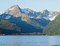
Mount Alice is a 5,318-foot (1,621 m) mountain summit in the U.S. state of Alaska.

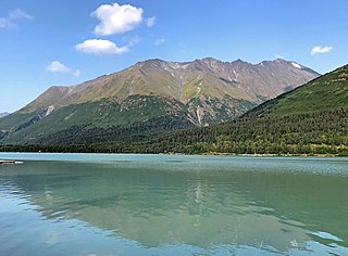
Mount Alpenglow is a 4,816-foot (1,468 m) landmark mountain located in the Kenai Mountains, in the U.S. state of Alaska. The peak is situated in Chugach National Forest, 8 mi (13 km) southwest of Girdwood, Alaska, on the south shore of Turnagain Arm, opposite Bird Point from where it can be prominently seen from the Seward Highway and the Alaska Railroad. Mount Alpenglow is the highest peak alongside Turnagain Arm, and although modest in elevation, relief is significant since the northern aspect of the mountain rises nearly a vertical mile in only one mile from the sea-level shores. The summit of Penguin Peak offers another good view of Alpenglow 6 mi (10 km) directly across the arm.

Mount Benson is a 4,465-foot (1,361 m) mountain summit located in the Kenai Mountains, on the Kenai Peninsula, in the U.S. state of Alaska. The peak is situated in Chugach National Forest, rising above the Resurrection River and Resurrection Bay, 3.3 mi (5 km) south of Resurrection Peaks, 2.35 mi (4 km) north of Marathon Mountain, and 3.1 mi (5 km) northwest of Seward, Alaska. Originally named Iron Mountain, the mountain's name was officially changed in 1974 by the United States Geological Survey to honor Benny Benson (1913-1972), who at age 13 designed Alaska's flag in 1927, as a student in Seward.

Mount Ascension is a prominent 5,710-foot (1,740 m) mountain summit located in the Kenai Mountains, on the Kenai Peninsula, in the U.S. state of Alaska. The mountain is situated in Chugach National Forest, 6.8 mi (11 km) south of Mount Adair, 3.5 mi (6 km) north of Resurrection Peaks, and 10 mi (16 km) north of Seward, Alaska. The peak is near the mouth of Resurrection River into Resurrection Bay. The name Resurrection, referring to the Resurrection of Jesus, is overused for nearby landforms on the Kenai peninsula, as the mountain to the immediate south is Resurrection Peaks. This Ascension name is a variation of the theme. Mount Ascension's name was proposed in 1968 by the Mountaineering Club of Alaska, and officially adopted in 1969 by the United States Geological Survey. Access to the peak is via the Lost Lake Trail, and mountaineering skills are needed to reach the summit. In clear weather the immense Harding Icefield can be seen from the top. The first ascent of this peak was made October 6, 1968, by John Vincent Hoeman and his wife, Dr. Grace (Jansen) Hoeman.
Phoenix Peak is a 5,187-foot (1,581 m) mountain summit located in the Kenai Mountains, on the Kenai Peninsula, in the U.S. state of Alaska. The peak is situated in Kenai Fjords National Park, 2 mi (3 km) southwest of Mount Benson, 1.1 mi (2 km) northwest of Marathon Mountain, and 3.5 mi (6 km) west of Seward, Alaska. Precipitation runoff from the mountain and meltwater from its glaciers drains into tributaries of the Resurrection River. The first ascent of the peak was made July 23, 1964, by Don Stockard of the Mountaineering Club of Alaska. The peak was named in 1965 by the Mountaineering Club of Alaska for the first ship ever built in Russian America, the Phoenix, which was constructed in 1794 by Russians in nearby Resurrection Bay. The mountain's toponym was officially adopted in 1966 by the United States Geological Survey.

Mount Adair is a prominent 5,178-foot (1,578 m) double summit mountain located in the Kenai Mountains, on the Kenai Peninsula, in the U.S. state of Alaska. The east summit is higher than the 4,940-foot west peak. The mountain is situated in Chugach National Forest, 6.8 mi (11 km) north of Mount Ascension, 7.2 mi (12 km) west of Andy Simons Mountain, and 17 mi (27 km) north of Seward, Alaska. Precipitation runoff from the mountain drains into Kenai Lake. Mount Adair's local name was reported in 1951 by the U.S. Geological Survey.
Andy Simons Mountain is a prominent 6,407-foot (1,953 m) double summit mountain located in the Kenai Mountains, and the fourth-highest peak on the Kenai Peninsula in the state of Alaska. The true summit is 1.3 mile west of the 5,300+ foot subsidiary east peak on this five-mile-long northwest-to-southeast trending mountain. The mountain is situated in Chugach National Forest, 7.2 mi (12 km) east of Mount Adair, and 17 mi (27 km) north of Seward, Alaska. The Seward Highway and Alaska Railroad traverse its western foot. Precipitation runoff from the mountain drains into Kenai Lake.

Bear Mountain is a 4,019-foot (1,225 m) mountain summit located in the Kenai Mountains, on the Kenai Peninsula, in the U.S. state of Alaska. The peak is situated in Chugach National Forest, 5 mi (8 km) northeast of Bear Glacier, 2.1 mi (3 km) south-southeast of Marathon Mountain, and 5 mi (8 km) southwest of Seward, Alaska. The peak's local name was reported in 1951 by the U.S. Geological Survey. The months May and June offer the most favorable weather for viewing the mountain. In fair weather, the Harding Icefield can be seen from the summit.

Lowell Peak is a 4,416-foot (1,346 m) mountain summit located in the Kenai Mountains, on the Kenai Peninsula, in the U.S. state of Alaska. The peak is situated in Chugach National Forest, 1.2 mi (2 km) northwest of Bear Mountain, 1.5 mi (2 km) south-southwest of Marathon Mountain, 2.2 mi (4 km) south of Phoenix Peak, and 3 mi (5 km) west-southwest of Seward, Alaska. The months May and June offer the most favorable weather for viewing the mountain. In fair weather, the Harding Icefield can be seen from the summit, as well as Mount Alice on the opposite side of Resurrection Bay. This unofficially named peak takes its name from Franklin G. Lowell and his family who were the first homesteaders to settle the Seward area in 1883.

Passage Peak is a prominent 5,990-foot (1,826 m) mountain summit located in the Chugach Mountains, in the U.S. state of Alaska. The unofficially named peak is situated in Chugach National Forest, 9 mi (14 km) northeast of Whittier, Alaska, near the isthmus of the Kenai Peninsula, where the Chugach Mountains meet the Kenai Mountains. Nearby peaks include Maynard Mountain and Boggs Peak, each approximately 10 mi (16 km) to the southwest. Although modest in elevation, relief is significant since the southern aspect of the mountain rises up from the tidewater of Prince William Sound's Passage Canal in approximately five miles. The peak takes its name from Passage Canal, which in turn was named in 1794 by Captain George Vancouver, presumably because it leads to a portage connecting Prince William Sound with Cook Inlet.

Mount Emma is a 13,581-foot-elevation (4,139-meter) mountain summit located in San Miguel County of Colorado, United States. It is situated three miles north of the community of Telluride, on the south side of Yankee Boy Basin, in the Uncompahgre National Forest. It is part of the Sneffels Range which is a subset of the San Juan Mountains, which in turn is part of the Rocky Mountains. Mount Emma is situated west of the Continental Divide, two miles south of Mount Sneffels, and 0.8 mile south of Gilpin Peak, the nearest higher neighbor. Emma ranks as the 197th-highest peak in Colorado, and the 10th-highest in the Sneffels Range. Topographic relief is significant as the south aspect rises 4,830 feet above Telluride in approximately three miles. An ascent of Mt. Emma is a difficult climb with 2,180 feet of elevation gain covering three miles from Yankee Boy Basin, or 4,836 feet of elevation gain from Telluride. This mountain's name was officially adopted by the U.S. Board on Geographic Names.

Mount Madson, also known as Madson Mountain, is a prominent 5,266-foot (1,605 m) summit in the U.S. state of Alaska.
Santa Ana Peak is a 4,764-foot-elevation (1,452-meter) mountain summit in Alaska, United States.

Mount Eva is a 5,019-foot-elevation (1,530-meter) mountain summit in Alaska, United States.

Tiehacker Mountain is a 4,435-foot-elevation (1,352-meter) mountain summit in Alaska, United States.

Mount Chichantna is a 10,893-foot-elevation (3,320-meter) mountain summit in Alaska.
Hearth Mountain is a 6,182-foot-elevation (1,884-meter) mountain summit in Alaska, United States.

Paradise Peak is a 6,050-foot-elevation (1,844-meter) mountain summit in Alaska, United States.

Mount McGhan is a 4,730-foot-elevation (1,442-meter) mountain summit in Alaska, United States.

Sheep Mountain is a 6,305-foot-elevation (1,922-meter) summit in Alaska, United States.