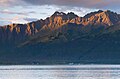
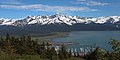
Mount Eva | |
---|---|
Highest point | |
Elevation | 5,019 ft (1,530 m) [1] |
Prominence | 525 ft (160 m) [1] |
Isolation | 1.95 mi (3.14 km) [2] |
Coordinates | 60°10′01″N149°16′06″W / 60.1668150°N 149.2683407°W [3] |
Geography | |
Interactive map of Mount Eva | |
Country | United States |
State | Alaska |
Borough | Kenai Peninsula |
Protected area | Chugach National Forest |
Parent range | Kenai Mountains [2] |
Topo map | USGS Seward A-7 |
Mount Eva is a 5,019-foot-elevation (1,530-meter) mountain summit in Alaska, United States.
Mount Eva is located seven miles (11 km) northeast of Seward in the Kenai Mountains, on land managed by Chugach National Forest. [3] Precipitation runoff and glacial meltwater from the mountain drains to Resurrection Bay five miles (8.0 km) to the southwest. Although modest in elevation, topographic relief is significant as the summit rises 4,500 feet (1,371 m) above Salmon Creek in 2.25 miles (3.62 km). The mountain's toponym was officially adopted December 13, 2001, by the United States Board on Geographic Names. [3] The mountain is named for Eva Lowell (1884–1951), whose family were early settlers of Seward. [3] Eva was the daughter of Mary Lowell (Mount Mary) and sister to Alice (Mount Alice). [4]
Based on the Köppen climate classification, Mount Eva is located in a tundra climate zone with long, cold, snowy winters, and mild summers. [5] Weather systems coming off the Gulf of Alaska are forced upwards by the Kenai Mountains (orographic lift), causing heavy precipitation in the form of rainfall and snowfall. Winter temperatures can drop below 0 °F with wind chill factors below −10 °F. This climate supports the Bear Lake Glacier on the north and east flanks of the peak as well as a smaller unnamed glacier on the west slope.
Mount Alice is a 5,318-foot (1,621 m) mountain summit in the U.S. state of Alaska.
Mount Alpenglow is a 4,816-foot (1,468 m) landmark mountain located in the Kenai Mountains, in the U.S. state of Alaska. The peak is situated in Chugach National Forest, 8 mi (13 km) southwest of Girdwood, Alaska, on the south shore of Turnagain Arm, opposite Bird Point from where it can be prominently seen from the Seward Highway and the Alaska Railroad. Mount Alpenglow is the highest peak alongside Turnagain Arm, and although modest in elevation, relief is significant since the northern aspect of the mountain rises nearly a vertical mile in only one mile from the sea-level shores. The summit of Penguin Peak offers another good view of Alpenglow 6 mi (10 km) directly across the arm.
Phoenix Peak is a 5,187-foot (1,581 m) mountain summit located in the Kenai Mountains, on the Kenai Peninsula, in the U.S. state of Alaska. The peak is situated in Kenai Fjords National Park, 2 mi (3 km) southwest of Mount Benson, 1.1 mi (2 km) northwest of Marathon Mountain, and 3.5 mi (6 km) west of Seward, Alaska. Precipitation runoff from the mountain and meltwater from its glaciers drains into tributaries of the Resurrection River. The first ascent of the peak was made July 23, 1964, by Don Stockard of the Mountaineering Club of Alaska. The peak was named in 1965 by the Mountaineering Club of Alaska for the first ship ever built in Russian America, the Phoenix, which was constructed in 1794 by Russians in nearby Resurrection Bay. The mountain's toponym was officially adopted in 1966 by the United States Geological Survey.
Mount Adair is a prominent 5,178-foot (1,578 m) double summit mountain located in the Kenai Mountains, on the Kenai Peninsula, in the U.S. state of Alaska. The east summit is higher than the 4,940-foot west peak. The mountain is situated in Chugach National Forest, 6.8 mi (11 km) north of Mount Ascension, 7.2 mi (12 km) west of Andy Simons Mountain, and 17 mi (27 km) north of Seward, Alaska. Precipitation runoff from the mountain drains into Kenai Lake. Mount Adair's local name was reported in 1951 by the U.S. Geological Survey.
Andy Simons Mountain is a prominent 6,407-foot (1,953 m) double summit mountain located in the Kenai Mountains, and the fourth-highest peak on the Kenai Peninsula in the state of Alaska. The true summit is 1.3 mile west of the 5,300+ foot subsidiary east peak on this five-mile-long northwest-to-southeast trending mountain. The mountain is situated in Chugach National Forest, 7.2 mi (12 km) east of Mount Adair, and 17 mi (27 km) north of Seward, Alaska. The Seward Highway and Alaska Railroad traverse its western foot. Precipitation runoff from the mountain drains into Kenai Lake.
Bear Mountain is a 4,019-foot (1,225 m) mountain summit located in the Kenai Mountains, on the Kenai Peninsula, in the U.S. state of Alaska. The peak is situated in Chugach National Forest, 5 mi (8 km) northeast of Bear Glacier, 2.1 mi (3 km) south-southeast of Marathon Mountain, and 5 mi (8 km) southwest of Seward, Alaska. The peak's local name was reported in 1951 by the U.S. Geological Survey. The months May and June offer the most favorable weather for viewing the mountain. In fair weather, the Harding Icefield can be seen from the summit.
Lowell Peak is a 4,416-foot (1,346 m) mountain summit located in the Kenai Mountains, on the Kenai Peninsula, in the U.S. state of Alaska. The peak is situated in Chugach National Forest, 1.2 mi (2 km) northwest of Bear Mountain, 1.5 mi (2 km) south-southwest of Marathon Mountain, 2.2 mi (4 km) south of Phoenix Peak, and 3 mi (5 km) west-southwest of Seward, Alaska. The months May and June offer the most favorable weather for viewing the mountain. In fair weather, the Harding Icefield can be seen from the summit, as well as Mount Alice on the opposite side of Resurrection Bay. This unofficially named peak takes its name from Franklin G. Lowell and his family who were the first homesteaders to settle the Seward area in 1883.
Passage Peak is a prominent 5,990-foot (1,826 m) mountain summit located in the Chugach Mountains, in the U.S. state of Alaska. The unofficially named peak is situated in Chugach National Forest, 9 mi (14 km) northeast of Whittier, Alaska, near the isthmus of the Kenai Peninsula, where the Chugach Mountains meet the Kenai Mountains. Nearby peaks include Maynard Mountain and Boggs Peak, each approximately 10 mi (16 km) to the southwest. Although modest in elevation, relief is significant since the southern aspect of the mountain rises up from the tidewater of Prince William Sound's Passage Canal in approximately five miles. The peak takes its name from Passage Canal, which in turn was named in 1794 by Captain George Vancouver, presumably because it leads to a portage connecting Prince William Sound with Cook Inlet.
Mount Madson, also known as Madson Mountain, is a prominent 5,266-foot (1,605 m) summit in the U.S. state of Alaska.
Santa Ana Peak is a 4,764-foot-elevation (1,452-meter) mountain summit in Alaska, United States.
Mount Mary is a 4,820-foot-elevation (1,469-meter) mountain summit in Alaska, United States.
Mount Sumdum is a 6,666-foot-elevation (2,032-meter) mountain summit in Alaska, United States.
Tiehacker Mountain is a 4,435-foot-elevation (1,352-meter) mountain summit in Alaska, United States.
Mount Gerdine is an 11,258-foot-elevation (3,431-meter) mountain summit in Alaska.
Mount Chichantna is a 10,893-foot-elevation (3,320-meter) mountain summit in Alaska.
Hearth Mountain is a 6,182-foot-elevation (1,884-meter) mountain summit in Alaska, United States.
Paradise Peak is a 6,050-foot-elevation (1,844-meter) mountain summit in Alaska, United States.
Haydon Peak is an 11,924-foot-elevation (3,634-meter) mountain summit in Alaska, United States.
Mount McGhan is a 4,730-foot-elevation (1,442-meter) mountain summit in Alaska, United States.
Sheep Mountain is a 6,305-foot-elevation (1,922-meter) summit in Alaska, United States.