The Babri Masjid was a mosque in Ayodhya, India. Located in Faizabad district, it was one of the largest mosques in the Uttar Pradesh state. Before the 1940s, the masjid was officially known as Masjid-i-Janmasthan. According to the mosque's inscriptions, it was built in 1528–29 by Mir Baqi, on orders of the Mughal emperor Babur.

Aligarh is a city in the Indian state of Uttar Pradesh that is famous for its lock industries. It is the administrative headquarters of the Aligarh district. It lies 307 kilometres (191 mi) northwest of Kanpur and is approximately 145 kilometres (90 mi) southeast of the capital, New Delhi. Notable as the seat of Aligarh Muslim University, Aligarh is the 8th largest city in Uttar Pradesh and 55th largest city in India.

Adambakkam is a neighbourhood of Chennai, India. It is a thickly populated area close to St. Thomas Mount railway station. Adambakkam area comes under Velachery taluk and Alandur taluk, Chennai District of Chennai Corporation. Adambakkam is surrounded by areas namely, Alandur, Palavanthangal, Nanganallur, Thalakanancheri, Vanuvampet, Puzhuthivakkam, Velachery and Guindy. Earlier, one part of Adambakkam was under the direct governance of Chennai Corporation. From October 2011 onwards, the entire area was merged with the Chennai Corporation. Upon completion of the MRTS extension line, the neighbourhood will be served by Adambakkam railway station.

Jaunpur (Hindustani pronunciation: [dʒɔːnpʊr] is a city and a municipal board in Jaunpur district in the Indian state of Uttar Pradesh. It is located 228 km southeast of state capital Lucknow.

Anna Nagar, is a neighbourhood in the metropolitan city of Chennai, India. Named after the Tamil leader C. N. Annadurai, it is located in the north-western part of Chennai and forms a part of the Aminjikarai taluk and the Anna Nagar Zone. It is one of the prime residential areas in Chennai and is home to several prominent doctors, lawyers and politicians. Real estate prices are among the highest in the city. A recent addition to the area is VR Chennai Mall, located near Shanthi Colony and Thirumangalam junction.

Jajmau also known as Jajesmow, is a suburb of Kanpur, India. It is situated on the banks of the Ganges River. Jajmau is an industrial suburb. It has the population of about 652,831 according to census 2011. It is believed to be the oldest inhabited place in the region. The main industry is the leather industry. It is home to some of the biggest leather tanneries in Northern India. The excavations conducted here by the Archaeological Survey of India suggest that it dates back to c. 1300 – 1200 BCE. Earthen pottery, tools and various historical artifacts discovered by the Archaeological Survey of India are presently kept in the Kanpur Sangrahalaya. The area comes under the jurisdiction of Kanpur metropolitan area.
Biaora is a city and municipality in Rajgarh district in the state of Madhya Pradesh, India. Biaora is one of the six tehsils of Rajgarh district. The primary languages spoken in Biaora are Malvi and Hindi. It is situated on Agra-Bombay Road, around 100 kilometers from Bhopal. Biaora is 200 km from Indore. The city is well connected to Indore, Jabalpur, Mumbai, Delhi, Ahmedabad, Chandigarh by train and road. Biaora railway station is the main railway station of the district. NH-3 and Nh-12 passes through the city. It is the main commercial centre of the district.
Dhanaura is a city and a municipal board in Amroha district in the state of Uttar Pradesh, India. Dhanaura is also known as Mandi Dhanaura, its native name.

Eruvadi is a town panchayath in Tirunelveli district in the state of Tamil Nadu, India.
Mr.M. A.Azad is the ex president of Eruvadi.
Manikpur is a town and a nagar panchayat in Pratapgarh district in the Indian state of Uttar Pradesh.
Sidhauli is a town and an Ideal Notified Area Council in Sitapur district in the Indian state of Uttar Pradesh. It comes under Lucknow division and is in the Awadh region of eastern Uttar Pradesh. Four-lane National Highway 24 passes from the centre of the town. It comes under Mohanlalganj. Sidhauli also a Sidhauli of Utter Pradesh Legislative Assembly.
It is Headquarter of Tehsil Sidhauli and Sidhauli Community Development Block. Sidhauli Block contain 306 Gram Panchayats.
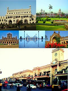
Trans-Gomti area is an important sub-city in the Lucknow city with its population slightly less than the main city. It is relatively more developed than the mainland due to the contemporary planning. It is divided into the following areas:

Hasmathpet is a small town which comes under Old Bowenpally in Secunderabad, India. It is predominantly a middle class area in Old Bowenpally. The historic Hasmathpet cairns, a medieval historical site is located here.
Chelari or Tenhipalam is a panchayat in Tirurangadi Taluk in Malappuram district of Kerala in India. The population was 27,273 at the 2001 census, with 13,293 males and 13,980 females. Indian census. Tenhipalam is known for the University of Calicut, which is the first university in Malabar region. The university is located north-west part of Tenhipalam. 'Chelari' is the main commercial place in Tenhipalam panchayat while 'Panambra' is considered as the headquarters of the panchayat. Hindus form the majority. The small town between Chelari and the University is called Kohinoor.
Belthara Road is a Nagar Panchayat city with a railway station in the north-western corner of Ballia district of Uttar Pradesh, India.

Medininagar, formerly known as Daltonganj, is a city municipal corporation in the Indian state of Jharkhand. It is the headquarters of Palamu division and Palamu district, as well as the subdivision and block of the same name. The city is situated on the banks of the North Koel River.

Railpar is a northern neighborhood in Asansol, in Asansol Sadar subdivision of Paschim Bardhaman district in the Indian state of West Bengal. It is one of the important places of the city. The area is located near the Asansol Railway Station. The other neighbourhoods of Asansol that are close to Railpar area are Kalyanpur Housing, Dhadka, ADDA etc. It is one of the oldest neighbourhood in Asansol and the residents are from different communities and religions like Hindus, Muslims, Sikhs and Christian, which adds to the cosmopolitan nature of the area and the city of Asansol.
Gomti Nagar railway station is a small railway station in Lucknow district, Uttar Pradesh. Its code is GTNR. It serves Gomti Nagar area of Lucknow city. The station consists of three platforms.
Aishbagh railway station used to serve the 130 years old metre gauge railway network, and used to act as a terminal for it. On 15 May 2016 the gauge conversion process started in which the Aishbagh – Sitapur section is being upgraded to broad gauge.