
Faizabad is a city located in Ayodhya district in the Indian state of Uttar Pradesh. It is situated on the southern bank of the River Saryu about 6.5 km from Ayodhya City, the district headquarter, 130 km east of the state capital Lucknow. Faizabad was the first capital of the Nawabs of Awadh and has monuments built by those Nawabs, like the Tomb of Bahu Begum, Gulab Bari. It was also the headquarters of Faizabad district and Faizabad division before November 2018. Faizabad is a twin city of Ayodhya and it is administered by Ayodhya Municipal Corporation.

Sultanpur is a city situated in the Indian state of Uttar Pradesh on the banks of the Gomti, which Hindus consider a holy river. The city is the administrative headquarters of Sultanpur district and is a part of Ayodhya division in Uttar Pradesh, India. It is situated 135 kilometers east of state capital Lucknow.

The North–South–East–West r (NS-EW) is the largest ongoing highway project in India. It is the second phase of the National Highways Development Project (NHDP), and consists of building 7300 kilometers of four/six lane highways associating Srinagar, Kanyakumari, Kochi, Porbandar and Silchar, at a cost of US$12.317 billion ₹1000000000000(One lakh Crore INR). As of 19 March 2024, 6875 of the 7142 kilometers project has been finished.
Uttar Pradesh is the most populous state in India with a population of nearly 240 million people. The economy of Uttar Pradesh is the fourth largest among states in India. The gross state domestic product (GSDP) of Uttar Pradesh increased from Rs 22.58 lakh crore in 2022–2023 to Rs 25.48 lakh crore in 2023–2024. According to chief minister Yogi Adityanath Uttar Pradesh, GSDP might hit 32 lakh crore by March 2025. Merchandise exports from Uttar Pradesh reached US$21.03 billion in FY22.
Delhi, a major metropolitan region of India, is connected to various parts of country through several national highways and expressways. All the highways and expressways from Delhi lead to Haryana or Uttar Pradesh and continue from there.
National Highway 44 is a major north–south National Highway in India and is the longest in the country.

Old National Highway 2 or Old NH 2, was a major National Highway in India, that connected the states of Delhi, Haryana, Uttar Pradesh, Bihar, Jharkhand and West Bengal. It constitutes a major portion of the historical Grand Trunk Road along with old NH 91 and old NH 1 in India. The highway connects national capital Delhi with Kolkata as well as important cities such as Faridabad, Mathura, Agra, Kanpur, Allahabad, Varanasi, Dhanbad, Asansol, Durgapur and Bardhaman.

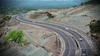
Expressways are the highest class of roads in India. In July 2023, the total length of expressways in India was 5,930 km (3,680 mi), with 11,127.69 km (6,914.43 mi) under construction. These are controlled-access highways designed for high vehicular movement with speed limit of 120 km/h and entrance and exits are controlled by grade separated system interchanges whereas National highways are flyover access or tolled, where entrance and exit are done by service interchanges, flyovers are provided to bypass the city/town/village traffic and these highways are designed for speed of 100 km/h. Some roads are declared as expressways by their respective State Governments but not by the Government of India, such as Bagodara–Tarapur Expressway, Biju Expressway etc.
The Indian city of Thiruvananthapuram has a well-developed transport infrastructure. The city and its suburbs may be traversed using road and rail. Within the city, city buses, taxis and auto rickshaws provide mobility. Scooters and motorcycles are the favored means of personal transport. Ola, Uber and other taxi services operate there.

Prayagraj Bypass Expressway is an 84.708 km (52.635 mi) Controlled-access expressway located in the district of Prayagraj. It is the Asia's longest bypass in terms of length. The project is a section of National Highway 19. It forms the part of the Golden Quadrilateral, under the Kanpur-Prayagraj-Varanasi section of Delhi-Kolkata stretch. The primary purpose of construction was to reduce heavy traffic on the Grand Trunk Road through the city of Prayagraj.
Lambhua is a town, tehsil, and a Nagar panchayat in Sultanpur district in the Indian state of Uttar Pradesh. It is located on the National Highway 731.
Lohia path is an 8–12 lane road in Lucknow, in the Indian state of Uttar Pradesh, connecting the Hazratganj shopping district with Government Polytechnic, the Gomti Nagar neighborhood and ending at Kalidas Marg, the residence of Uttar Pradesh's chief minister. It displays beautiful railings and lamp posts on both sides. In addition to vehicular lanes, it includes a bicycle track and footpath. It was built under the government of Mulayam Singh Yadav in 2005 and was inaugurated in 2007.
Rajesultanpur or Raje Sultanpur is a town and nagar panchayat in Ambedkar Nagar district in the Indian state of Uttar Pradesh.
National Highway 27, an East - West National highway in India that starts in Porbandar and ends in Silchar, the highway passes through the states of Gujarat, Rajasthan, Madhya Pradesh, Uttar Pradesh, Bihar, West Bengal, Assam. NH-27 was laid and is maintained by Ministry of Road Transport and Highways (MoRTH). It is the second longest National Highway in India and is a part of NS-EW Corridor of NHAI.
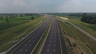
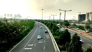
Purvanchal Expressway is a 340.8 km long, 6-lane wide access-controlled expressway in the state of Uttar Pradesh, India. The expressway connects Chand Saray village near Gosainganj in Lucknow district with Haydaria village on NH-31 in Ghazipur district. It is developed by the Uttar Pradesh Expressways Industrial Development Authority (UPEIDA). The Purvanchal Expressway has a 3.2 km long airstrip at Akhalkiri Karwat village near Kurebhar in Sultanpur district for emergency landing of aircraft. The construction work was started by the UPEIDA on 10 October 2018 and was inaugurated and opened to the public on 16 November 2021.
National Highway 330 is a national highway in India that links Prayagraj, Uttar Pradesh to Balrampur in Uttar Pradesh. Previously this highway was named NH-96. NH 330 is a 4 Lane highway in UP.

National Highway 230, also known as Kisan Path or Lucknow Outer Ring Road is National Highway in Uttar Pradesh, India which also includes sections of Lucknow Inner Ring Road. The Lucknow outer ring road is an 8 lane that expand to 10 lanes at key junctions and 104 km long quadruple carriageway road project with a speed limit of 100kmph for Light Vehicles and 80kmph for Heavy vehicles. The 6 lane 11 km long stretch between Kursi Road to Sultanpur road has been constructed by the NHAI. This Ring Road has multiple 6 lane flyovers for smooth and swift commuting of the travellers. This Outer Ring Road will play a major role in the establishment of the Lucknow State Capital Region or the Uttar Pradesh State Capital Region as many IT cities, Housing Societies, Integrated Mega-Townships, Wellness City, Educational Hubs, and Commercial Hubs etc. across Multiple 1000's of acres of land are proposed to be established around this Ring Road. It is set to offload nearly 1.60 lakh vehicles off the main roads of the city of Lucknow as of now.
Seth M.R. Jaipuria Schools is a group of schools run by the Seth M.R. Jaipuria Group. The schools draw their name from 1971 Padma Bhushan awardee Mungtu Ram Jaipuria, a philanthropist and industrialist who played a dominant role in the industrialization of the nation after independence.
The Ring Road is an elevated section of road at Raebareli in Uttar Pradesh, India. It is an outer bypass road and crosses the Sharda River. It has been constructed to divert the traffic coming from Lucknow Road or Allahabad Road and vice versa, allowing vehicles to get to their destinations without entering the city of Raebareli. The Second phase is 22 km long with four lane road.
The Awadh Expressway also known as Lucknow-Kanpur Expressway connects two major cities Lucknow and Kanpur of the Awadh Region of Uttar Pradesh. It is an under-construction, 63-kilometre-long (39 mi), six-lane wide access-controlled expressway in India's Uttar Pradesh. It has been given the status of National Expressway 6 by the Government of India.