Maasai Mara, also sometimes spelled Masai Mara and locally known simply as The Mara, is a large national game reserve in Narok, Kenya, contiguous with the Serengeti National Park in Tanzania. It is named in honour of the Maasai people, the ancestral inhabitants of the area, who migrated to the area from the Nile Basin. Their description of the area when looked at from afar: "Mara" means "spotted" in the local Maasai language, because of the short bushy trees which dot the landscape.
Kamwenge District is a district in Western Uganda. It is named after its 'chief town', Kamwenge, where the district headquarters are located. Kamwenge District is part of the Kingdom of Toro, one of the ancient traditional monarchies in Uganda. The kingdom is coterminous with Toro sub-region. The districts that constitute the sub-region are: (a) Bunyangabu District (b) Kabarole District (c) Kamwenge District (d) Kyegegwa District (e) Kitagwenda District and (f) Kyenjojo District.

Queen Elizabeth National Park is a national park in Uganda.

Murchison Falls National Park (MFNP) is a national park in Uganda managed by the Ugandan Wildlife Authority. It is in north-western Uganda, spreading inland from the shores of Lake Albert, around the Victoria Nile, up to the Karuma Falls.
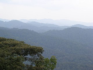
The Albertine Rift montane forests is a tropical moist broadleaf forest ecoregion in east-central Africa. The ecoregion covers the mountains of the northern Albertine Rift, and is home to distinct Afromontane forests with high biodiversity.

Conservation in Uganda is the protection and sustainable use of the country's rich natural resources. It became a significant movement during the British colonial period in the early 20th century and continues to play a major role in Uganda's political economy, as it underpins the tourism industry which accounts for 23.5% of the country's exports.
Paraa is a location in Northern Uganda.
Pakuba Airfield is an airfield serving Pakuba and Murchison Falls National Park in the Nwoya District of northern Uganda.
Mweya Airport is a small civilian airport in Uganda. It is one of the 46 airports in the country.

The Semliki Wildlife Reserve is a conservation protected area in the Western Region of Uganda with headquarters at Karugutu in Ntoroko District.
Ntoroko is a town officially known as Kanara Town Council in Ntoroko District Western Uganda. It is one of the four town councils of Ntoroko District the others being Karugutu, Rwebisengo and Kibuku Town Council. Ntoroko is the largest fishing town on the southern Mwitanzige shore. Its located on the Ntoroko bay extending from Kanara Fishing village to the western half of the Ntoroko Peninsula. The peninsular also separates Ntoroko bay from the Muziizi Bay. By Road, Ntoroko town is approximately 84 KM Northwest of Fort Portal City, the regional Capital and approximately 79 KM via Karugutu, north of Kibuku Town Council the District Capital. Ntoroko/Kanara Town Council is settled by many ethnicities, the largest being; Rwenzori Peoples; Batooro/Batuku, Bakonzo, Bamba, Babwisi. Bunyoro peoples; Bagangaizi,Bagungu and other Banyoro. Alur, Lendu and Ngite. Congolese of the Western Mwitanzige shore; Alur, Gegere, Nande, to mention but a few.
Savannah Airstrip is an airport serving Savannah Resort and the town of Kihihi, Uganda. The airstrip receives daily flights from Entebbe International Airport and Kajjansi Airfield, a route frequently used by tourists to visit the south of Queen Elizabeth National Park and north of Bwindi Impenetrable National Park.
The Fort Portal–Bundibugyo–Lamia Road is in the Western Region of Uganda. It links Fort Portal in the Kabarole District with the towns of Bundibugyo and Lamia in the Bundibugyo District.
Chobe Safari Lodge Airport is an airport serving Murchison Falls National Park in Uganda. The runway is adjacent to the Chobe Safari Lodge, and alongside the rapids of the Nile River.
Bugungu Airstrip is an airport serving the Bugungu Wildlife Reserve in the Murchison Falls National Park (MFNP), in Uganda.
The Fort Portal–Kasese–Mpondwe Road also Fort Portal–Mpondwe Road, is a road in the Western Region of Uganda, connecting the towns of Fort Portal, Hima, Kasese, Kikorongo and the border town of Mpondwe.

Aerolink Uganda is a privately owned airline in Uganda, licensed by the Uganda Civil Aviation Authority with an air operator's certificate. It specializes in transporting tourists to Uganda's National Parks, saving their time and allowing them to see more.
Karugutu is a settlement in the Western Region of Uganda. The name "Karugutu" applies to;
Kitagwenda District is a district in Western Uganda. The district is named after Kitagwenda County, which is coterminous with the district.
Bugungu Wildlife Reserve is a protected area in both Buliisa District and Masindi districts in Western Uganda. It covers an area of 473.0 km2. It is managed by Uganda Wildlife Authority under the supervision of Ministry of Tourism, Wildlife and Antiquities. It was declared a Wildlife Reserve in 1968 but it was originally established as a Controlled Hunting Area in 1963. Its WDPA ID is 1438. It is IUCN Management Category III.