
The Wenatchee Mountains are a range of mountains in central Washington State, United States of America. A major subrange of the Cascade Range, extending east 50 miles (80 km) from the Cascade crest, the Wenatchee Mountains separate the drainage basins of the Yakima River from the Wenatchee River. The crest of the range forms part of the boundary between Chelan and Kittitas Counties.

The Entiat River is a tributary of the Columbia River, joining the Columbia near Entiat. The United States Geological Survey (USGS) lists two variant names for the Entiat River: En-ti-at-kwa River and Entiatqua River. The river's name is derived from the Columbia-Moses (Salishan) term /nt'yátkw/ [nt'iátkw], meaning "place of grassy water"; another source states that it was called Enteatqua which means "Rapid Water" or "Rushing Water." The name, spelled "Entiat", was selected for the river in 1958 by the Chelan County Public Utility District.
The Chiwawa River is a tributary of the Wenatchee River, in the U.S. state of Washington. It is completely contained within Chelan County.

Bonanza Peak is a tall peak in the North Cascades in the U.S. state of Washington and the Glacier Peak Wilderness of the Wenatchee National Forest. At 9,516 feet (2,900 m) in elevation, it is the highest point in Chelan County, and the highest non-volcanic peak in Washington. and the Cascade Range as a whole. Bonanza Peak's prominence is 3,711 feet (1,131 m), making it the 26th most prominent peak in Washington. The nearest higher peak is Glacier Peak, 14.4 miles (23.2 km) to the southwest.

Mount Fernow is a tall peak in the North Cascades in the U.S. state of Washington and within the Glacier Peak Wilderness of the Wenatchee National Forest. At 9,249 feet (2,819 m) in elevation it is the eighth-highest peak in Washington and the state's third-highest non-volcanic peak. It is also the highest peak of the Entiat Mountains, a sub-range of the Cascades. Mount Fernow's prominence is 2,811 ft (857 m), making it the sixtieth-most-prominent peak in Washington. The closest peak to Fernow is Copper Peak, 0.88 mi (1.42 km) to the north, and the nearest higher peak is Bonanza Peak, 5.9 mi (9.5 km) to the north.

Buckner Mountain is a tall peak in the North Cascades of Washington state and in the Stephen Mather Wilderness of North Cascades National Park. At 9,114 feet (2,778 m) in elevation it is the highest in Skagit County and one of about ten of Washington's non-volcanic peaks above 9,000 feet high. It is ranked as the 14th highest peak in the state, and the third highest peak in North Cascades National Park.

Boston Peak is a tall peak in the North Cascades in the U.S. state of Washington and within North Cascades National Park. At 8,894 feet (2,711 m) in elevation it is the 26th highest peak in Washington. Its nearest higher neighbor is Buckner Mountain, 1.66 miles (2.67 km) to the east.

The Entiat Mountains, or Entiat Range, is a mountain range in the U.S. state of Washington. Located west of the Columbia River, north of the Wenatchee River, and south of the Entiat River, the range is part of the North Cascades section of the Cascade Range. The Entiat Range is relatively narrow east to west and long north to south. The Entiat River valley separates the Entiat Mountains from the Chelan Mountains to the northeast. To the west and south, across the Wenatchee River and tributaries such as the Chiwawa River are the Wenatchee Mountains.

The Chelan Mountains, or Chelan Range is a mountain range in the U.S. state of Washington. Located west of the Columbia River, north of the Entiat River, and south of Lake Chelan, the range is part of the North Cascades section of the Cascade Range. The Chelan Range is about 40 mi (64 km) long northwest to southeast and about 8 mi (13 km) wide, southwest to northeast.

Mount Spickard is a 8,980-foot (2,740 m) mountain peak in the North Cascades, a mountain range in the U.S. state of Washington. Located 2 miles (3.2 km) south of the Canada–US border, it is part of the Chilliwack Group, a subrange of the Skagit Range which is part of the North Cascades. It is composed mainly of gneiss and is part of two major drainage basins: that of the Skagit River and Fraser River.

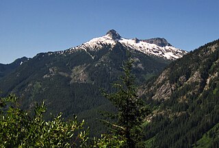
Mount Maude is the 15th highest peak in Washington state. The peak is located in the Entiat Mountains, a subrange of the North Cascades. It is in the Glacier Peak Wilderness, at the headwaters of the Entiat River. The peak was given its name by Albert H. Sylvester in honor of Frederick Stanley Maude.

Icicle Creek is a non navigable stream in the U.S. state of Washington. It originates at Josephine Lake near the crest of the Cascade Range and flows generally east to join the Wenatchee River near Leavenworth. Icicle Creek's drainage basin is mountainous and mostly undeveloped land within the Wenatchee National Forest and the Alpine Lakes Wilderness. The final 6 miles (10 km) of the creek are moderately developed with scattered homes and pasture, a golf course, children's camp, a small housing development called Icicle Island Club, and the Leavenworth National Fish Hatchery. Some water is diverted from the creek for municipal use by the City of Leavenworth at Icicle Creek river mile 5.6. Near Leavenworth, the wheelchair-accessible Icicle Creek Nature Trail, a National Recreation Trail designated in 2005, runs 1.0 mile (1.6 km) along a historic creek channel.

Albert Hale Sylvester was a pioneer surveyor, explorer, and forest supervisor in the Cascade Range of the U.S. state of Washington. He was a topographer for the United States Geological Survey (USGS) in the Snoqualmie Ranger District between 1897 and 1907. Then, from 1908 to 1931, he served the United States Forest Service as the first forest supervisor of Wenatchee National Forest. His work involved the first detailed surveying and mapping of large portions of the Cascade Range in Washington, over the course of which he gave names to over 1,000 natural features. The surveying work often required placing cairns and other survey targets on top of mountains. He made the first ascents of a number of mountains in Washington. Over the course of his career he explored areas previously unknown to non-indigenous people. One such area, which Sylvester discovered, explored, and named, is The Enchantments. In 1944, while leading a party of friends to one of his favorite parts of the mountains, Sylvester was mortally wounded when his horse panicked and lost his footing on a steep and rocky slope.
Cardinal Peak is the highest peak of the Chelan Mountains, a subrange of the Cascade Range in the U.S. state of Washington. It is located in Wenatchee National Forest at the head of the Entiat River drainage basin, in Chelan County. To the west and north, streams flow into Lake Chelan. Cardinal Peak is less than 5 miles (8.0 km) from the lake and rises 7,500 feet (2,300 m) above the lakeshore. At 8,595 feet (2,620 m) high, it is the 49th highest peak in Washington. Its 2,070-foot (630 m) prominence ranks 132nd in the state.

Napeequa Peak is an 8,073-foot (2,461-metre) pyramidal mountain summit located in the Glacier Peak Wilderness of the North Cascades in Washington state. The mountain is situated on the crest of the Cascade Range, on the shared border of Snohomish County and Chelan County, also straddling the boundary between the Mount Baker-Snoqualmie National Forest and the Wenatchee National Forest. Its nearest neighbor is Cirque Mountain, 0.3 mi (0.48 km) to the north, and the nearest higher peak is Buck Mountain, 2.56 mi (4.12 km) to the east-southeast. Precipitation runoff from the peak drains east to the headwaters of Napeequa River; or west into the Suiattle River. The mountain's name is taken from the river's name, which was applied by Albert Hale Sylvester (1871-1944), a pioneer surveyor, explorer, topographer, and forest supervisor in the Cascades.

Copper Peak is an 8,965-foot (2,733-metre) mountain summit located in the Entiat Mountains, a sub-range of the North Cascades, in Chelan County of Washington state. Copper Peak is situated 80 miles northeast of Seattle in the Glacier Peak Wilderness, on land managed by the Wenatchee National Forest. Copper Peak ranks 21st-highest on Washington's highest 100 peaks, and 19th on the "Bulger List." The nearest higher neighbor is Mount Fernow, 0.88 miles (1.42 km) to the south. Precipitation runoff from the mountain and meltwater from the glacier on the southeast slope drains into nearby Lake Chelan via Railroad Creek. The first ascent of the peak was made in August 1937 by Franklin Bennet, Edgar Courtwright, and Toivo Hagman. The peak's toponym refers to an abandoned copper mine that once operated at the northeast base of the peak.

Ice Box is an 8,112-foot (2,473-metre) mountain summit located in the Entiat Mountains, a sub-range of the North Cascades, in Chelan County of Washington state. Ice Box ranks as ninth-highest in the Entiat Mountains, and 147th of Washington's highest 200 peaks. Its nearest higher neighbor is Mount Maude, 1.8 miles (2.9 km) to the north, Spectacle Buttes are set 1.9 miles (3.1 km) to the northeast, and Chilly Peak is 1.3 miles (2.1 km) to the southeast. Ice Box is situated 1.25 miles (2.01 km) south of Ice Lakes in the Okanogan-Wenatchee National Forest. Precipitation runoff from the mountain drains east into Ice Creek, or west into Box Creek. This peak is positioned between these two creeks, hence its name.
Mount David is a prominent 7,420-foot (2,260-metre) mountain summit located in Chelan County of Washington state. The mountain is situated in the Glacier Peak Wilderness, on land managed by the Okanogan-Wenatchee National Forest. Mount David is the highest point of Wenatchee Ridge, a subrange which also includes Indian Head Peak, Whittier Peak, Mount Saul, and Mount Jonathan. Its nearest higher neighbor is Bandit Peak, 5.69 mi (9.16 km) to the east-northeast. Precipitation runoff from Mount David drains into tributaries of the White River. Although modest in elevation, relief is significant since Mt. David rises 5,100 feet above the White River Valley in two miles. This peak was named for the biblical David by Albert Hale Sylvester, a pioneer surveyor, explorer, topographer, and forest supervisor in the Cascades who named thousands of natural features. This mountain can be climbed via the strenuous seven-mile Mount David Trail with over 5,000 feet of elevation gain.
Carne Mountain is a 7,080+ ft double-summit mountain located in the Entiat Mountains, a sub-range of the North Cascades, in Chelan County of Washington state. Carne Mountain is situated on the boundary of the Glacier Peak Wilderness, on land managed by the Okanogan–Wenatchee National Forest. Its nearest higher neighbor is Chilly Peak, 1.4 miles (2.3 km) to the northeast, and Ice Box is set 1.7 miles (2.7 km) to the north. Precipitation runoff from the mountain drains east into Rock Creek, or west into Phelps Creek, both tributaries of the Chiwawa River. This peak can be accessed via the 3.7-mile Carne Mountain Trail which gains 3,600 feet of elevation. The mountain once had a fire lookout building on its south peak. Views from the top include Bandit Peak, Brahma Peak, Buck Mountain, Fortress Mountain, Chiwawa Mountain, Mount Maude, Ice Box, and Chilly. This mountain was named by Albert Hale Sylvester for English clergyman W. Stanely Carnes. This feature is pronounced "karn".


