Shade River

Last updated
Shade River
East Branch Shade River Ohio.jpg
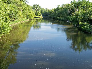
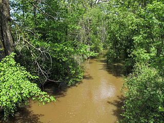
The East Branch of the Shade River in Chester Township in 2006
Shade River map.png
Map of the Shade River and its watershed
Location
Country United States
State Ohio
County Meigs
Physical characteristics
SourceWest Branch Shade River
 - location Scipio Township, Meigs County
 - coordinates 39°11′28″N82°09′24″W / 39.19111°N 82.15667°W / 39.19111; -82.15667 [1]
 - length20.8 mi (33.5 km)
 - elevation853 ft (260 m) [2]
2nd sourceMiddle Branch Shade River
 - location Athens Township, Athens County
 - coordinates 39°18′33″N82°04′52″W / 39.30917°N 82.08111°W / 39.30917; -82.08111 [3]
 - length28.5 mi (45.9 km)
 - elevation950 ft (290 m) [2]
Source confluence 
 - location Chester Township, Meigs County
 - coordinates 39°05′58″N81°55′21″W / 39.09944°N 81.92250°W / 39.09944; -81.92250 [4]
 - elevation574 ft (175 m) [2]
Mouth Ohio River
 - location
Olive Township, Meigs County
 - coordinates
39°04′03″N81°48′49″W / 39.06750°N 81.81361°W / 39.06750; -81.81361 Coordinates: 39°04′03″N81°48′49″W / 39.06750°N 81.81361°W / 39.06750; -81.81361 [4]
 - elevation
561 ft (171 m) [5]
Length17.4 mi (28.0 km) [6]
Basin size221 sq mi (570 km2) [6]
Discharge 
 - locationnear Chester [7]
 - average174 cu ft/s (4.9 m3/s) [7]
 - minimum0.00 cu ft/s (0 m3/s)
 - maximum15,600 cu ft/s (440 m3/s)
Basin features
Tributaries 
 - leftEast Branch Shade River

The Shade River is a tributary of the Ohio River in southeastern Ohio in the United States. Via the Ohio River, it is part of the watershed of the Mississippi River, draining an area of 221 square miles (570 km2) on the unglaciated portion of the Allegheny Plateau. The Shade River is 17.4 miles (28.0 km) long, or 38.2 miles (61.5 km) including its west branch. [6]

Tributary stream or river that flows into a main stem river or lake

A tributary or affluent is a stream or river that flows into a larger stream or main stem river or a lake. A tributary does not flow directly into a sea or ocean. Tributaries and the main stem river drain the surrounding drainage basin of its surface water and groundwater, leading the water out into an ocean.

Ohio River river in the eastern United States

The Ohio River, which flows southwesterly from Pittsburgh, Pennsylvania, to Cairo, Illinois, is the largest tributary, by volume, of the Mississippi River in the United States. At the confluence, the Ohio is considerably bigger than the Mississippi and, thus from a hydrological perspective, is the main stream of the whole river system.

United States federal republic in North America

The United States of America (USA), commonly known as the United States or America, is a country composed of 50 states, a federal district, five major self-governing territories, and various possessions. At 3.8 million square miles, the United States is the world's third or fourth largest country by total area and is slightly smaller than the entire continent of Europe's 3.9 million square miles. With a population of over 327 million people, the U.S. is the third most populous country. The capital is Washington, D.C., and the largest city by population is New York City. Forty-eight states and the capital's federal district are contiguous in North America between Canada and Mexico. The State of Alaska is in the northwest corner of North America, bordered by Canada to the east and across the Bering Strait from Russia to the west. The State of Hawaii is an archipelago in the mid-Pacific Ocean. The U.S. territories are scattered about the Pacific Ocean and the Caribbean Sea, stretching across nine official time zones. The extremely diverse geography, climate, and wildlife of the United States make it one of the world's 17 megadiverse countries.

Contents

The Shade River flows predominantly as three streams, its east, middle, and west branches. It is formed by the confluence of its middle and west branches, and collects its east branch shortly thereafter: [8]

Scipio Township, Meigs County, Ohio Township in Ohio, United States

Scipio Township is one of the twelve townships of Meigs County, Ohio, United States. The 2000 census found 1,050 people in the township.

Meigs County, Ohio county in Ohio, United States of America

Meigs County is a county located in the U.S. state of Ohio. As of the 2010 census, the population was 23,770. Its county seat is Pomeroy. The county is named for Return J. Meigs, Jr., the fourth Governor of Ohio.

Bedford Township, Meigs County, Ohio Township in Ohio, United States

Bedford Township is one of the twelve townships of Meigs County, Ohio, United States. The 2000 census found 1,212 people in the township.

From the confluence of the middle and west branches in Chester Township, the Shade River flows generally eastwardly, past the community of Chester. It collects its east branch from the north at the community of Keno, and enters the Ohio River in Olive Township, approximately one mile (2 km) south of the community of Long Bottom. [8]

Chester, Ohio human settlement in United States of America

Chester is an unincorporated community in central Chester Township, Meigs County, Ohio, United States. It lies along the Shade River at the intersection of State Routes 7 and 248. Although it is unincorporated, it has a post office, with the ZIP code of 45720.

Olive Township, Meigs County, Ohio Township in Ohio, United States

Olive Township is one of the twelve townships of Meigs County, Ohio, United States. The 2000 census found 1,874 people in the township.

Long Bottom, Ohio human settlement in United States of America

Long Bottom is an unincorporated community in southern Olive Township, Meigs County, Ohio, United States. Although it is unincorporated, it has a post office, with the ZIP code of 45743.

According to the Geographic Names Information System, the Shade River has also been known historically as "Shade Creek" and as "Devils Hole Creek." [4]

Geographic Names Information System geographical database

The Geographic Names Information System (GNIS) is a database that contains name and locative information about more than two million physical and cultural features located throughout the United States of America and its territories. It is a type of gazetteer. GNIS was developed by the United States Geological Survey in cooperation with the United States Board on Geographic Names (BGN) to promote the standardization of feature names.

Flow rate

At the United States Geological Survey's stream gauge downstream of Chester, the annual mean flow of the river between 1965 and 2012 was 174 cubic feet per second (5 cubic meters per second). The highest recorded flow during the period was 15,600 cfs (442 m³/s) on March 2, 1997. The lowest recorded flow was 0.00 cfs (0 m³/s) on September 5, 2007. [7]

United States Geological Survey scientific agency of the United States government

The United States Geological Survey is a scientific agency of the United States government. The scientists of the USGS study the landscape of the United States, its natural resources, and the natural hazards that threaten it. The organization has four major science disciplines, concerning biology, geography, geology, and hydrology. The USGS is a fact-finding research organization with no regulatory responsibility.

Stream gauge locations used to monitor surface water flow

A stream gauge, streamgage or gauging station is a location used by hydrologists or environmental scientists to monitor and test terrestrial bodies of water. Hydrometric measurements of water level surface elevation ("stage") and/or volumetric discharge (flow) are generally taken and observations of biota and water quality may also be made. The location of gauging stations are often found on topographical maps. Some gauging stations are highly automated and may include telemetry capability transmitted to a central data logging facility.

See also

Related Research Articles

Christina River river in Delaware, United States

The Christina River is a tributary of the Delaware River, approximately 35 miles (56 km) long, in northern Delaware in the United States, also flowing through small areas of southeastern Pennsylvania and northeastern Maryland. Near its mouth the river flows past downtown Wilmington, Delaware, forming the city's harbor for traffic on the Delaware River. The Port of Wilmington, opened in 1923 at the river's mouth, handles international cargo and trade.

Yellow Medicine River river in the United States of America

The Yellow Medicine River is a tributary of the Minnesota River, 107 miles (173 km) long, in southwestern Minnesota in the United States. Via the Minnesota River, it is part of the watershed of the Mississippi River, draining an area of 665 square miles (1,722 km²) in an agricultural region. Its name is a translation of the Dakota name for the river, pajutazee,,

Blue Earth River river in the United States of America

The Blue Earth River is a tributary of the Minnesota River, 108 miles (174 km) long, in southern Minnesota in the United States. Two of its headwaters tributaries, the Middle Branch Blue Earth River and the West Branch Blue Earth River, also flow for short distances in northern Iowa. By volume, it is the Minnesota River's largest tributary, accounting for 46% of the Minnesota's flow at the rivers' confluence in Mankato. Via the Minnesota River, the Blue Earth River is part of the watershed of the Mississippi River, draining an area of 3,486 square miles (9,029 km²) in an agricultural region. Ninety percent of the river's watershed is in Minnesota. It is a Minnesota Department of Natural Resources designated Water Trail.

Kokosing River river in the United States of America

The Kokosing River (ko-KO-sing) is a tributary of the Walhonding River, 57.2 miles (92.1 km) long, in east-central Ohio in the United States. Via the Walhonding, Muskingum and Ohio Rivers, it is part of the watershed of the Mississippi River, draining an area of 482 square miles (1248 km²). Etymologically, "Kokosing" translates roughly to "River of Little Owls." The Kokosing River rises in Morrow County, northeast of Mount Gilead, and initially flows southwardly. It turns eastwardly near Chesterville and flows through Knox and Coshocton Counties, passing the communities of Mount Vernon, Howard and Gambier. In western Coshocton County the Kokosing joins the Mohican River to form the Walhonding River, about 2 miles (3 km) northwest of Nellie.

Middle River (Iowa) river in Iowa

The Middle River is a tributary of the Des Moines River in south-central Iowa in the United States. It is 123 miles (198 km) long and drains an area of 489.5 square miles (1,268 km2). Via the Des Moines River, it is part of the watershed of the Mississippi River.

Sugar Creek (Tuscarawas River tributary) tributary of the Tuscarawas River in Ohio

Sugar Creek is a tributary of the Tuscarawas River in northeastern Ohio in the United States. It is 45 miles (72 km) long. Via the Tuscarawas, Muskingum, and Ohio Rivers, it is part of the watershed of the Mississippi River, draining an area of 356 square miles (922 km²) on glaciated and unglaciated portions of the Allegheny Plateau.

Tenmile Creek (West Fork River)

Tenmile Creek is a tributary of the West Fork River, 26.4 miles (42.5 km) long, in north-central West Virginia in the United States. Via the West Fork, Monongahela and Ohio Rivers, it is part of the watershed of the Mississippi River, draining an area of 126 square miles (330 km2) on the unglaciated portion of the Allegheny Plateau.

Wheeling Creek (West Virginia)

Wheeling Creek is a tributary of the Ohio River, 25 miles (40 km) long, in the Northern Panhandle of West Virginia in the United States, with a watershed extending into southwestern Pennsylvania. Via the Ohio River, it is part of the watershed of the Mississippi River, draining an area of approximately 300 square miles (780 km2) on the unglaciated portion of the Allegheny Plateau. It flows into the Ohio River in downtown Wheeling, just downstream of Ohio's Wheeling Creek on the opposite bank. A variant name is Big Wheeling Creek.

Wheeling Creek (Ohio) river in the United States of America

Wheeling Creek is a tributary of the Ohio River, 30.2 miles (48.6 km) long, in eastern Ohio in the United States. Via the Ohio River, it is part of the watershed of the Mississippi River, draining an area of 108 square miles (280 km2) on the unglaciated portion of the Allegheny Plateau. It flows for its entire length in Belmont County; its tributaries also drain small areas of south-eastern Harrison County and south-western Jefferson County.

Mill Creek (western West Virginia) tributary of the Ohio River in western West Virginia, USA

Mill Creek is a tributary of the Ohio River, 29.4 miles (47.3 km) long, in western West Virginia in the United States. Via the Ohio, it is part of the watershed of the Mississippi River, draining an area of 234 square miles (610 km2) on the unglaciated portion of the Allegheny Plateau. According to the Geographic Names Information System, it has also been known historically as Big Mill Creek.

Sandy Creek (Ohio River) creek in Ravenswood, West Virginia

Sandy Creek is a tributary of the Ohio River in western West Virginia in the United States. Via the Ohio River, it is part of the watershed of the Mississippi River, draining an area of 124 square miles (320 km2) on the unglaciated portion of the Allegheny Plateau. The creek is 22 miles (35 km) long, or 38.3 miles (61.6 km) including its Left Fork.

Blueberry River (Minnesota) river in the United States of America

The Blueberry River is a tributary of the Shell River, approximately twenty miles (30 km) long, in north-central Minnesota in the United States. Via the Shell and Crow Wing Rivers, it is part of the watershed of the Mississippi River, draining a rural area.

Batten Kill river in the United States of America

The Batten Kill, Battenkill, or Battenkill River is a 59.4-mile-long (95.6 km) river rising in Vermont that flows into New York and is a tributary of the Hudson River. As "kill" means a creek, the name "Battenkill River" is pleonastic.

Pinconning River river in the United States of America

The Pinconning River is a small river on the central Lower Peninsula of Michigan in the United States. It is 15.6 miles (25.1 km) long and flows to Saginaw Bay of Lake Huron, draining an area of 26.6 square miles (69 km2). Via Lake Huron and the Great Lakes system, it is part of the larger watershed of the St. Lawrence River.

Little Hocking River watercourse in the United States of America

The Little Hocking River is a small tributary of the Ohio River, 18.4 miles (29.6 km) long, in southeastern Ohio in the United States. Via the Ohio River, it is part of the watershed of the Mississippi River, draining an area of 102 square miles (260 km2) on the unglaciated portion of the Allegheny Plateau. The river flows for its entire length in southwestern Washington County; its tributaries also drain a small area of southeastern Athens County.

Leading Creek (Ohio)

Leading Creek is a tributary of the Ohio River, 29.5 miles (47.5 km) long, in southeastern Ohio in the United States. Via the Ohio River, it is part of the watershed of the Mississippi River, draining an area of 150 square miles (390 km2) on the unglaciated portion of the Allegheny Plateau. The creek's headwaters are in southern Athens County and it flows for most of its length in western Meigs County; its tributaries also drain a small area of northeastern Gallia County.

Pond Creek (West Virginia) river in the United States of America

Pond Creek is a tributary of the Ohio River, 16 miles (26 km) long, in western West Virginia in the United States. Via the Ohio River, it is part of the watershed of the Mississippi River, draining an area of 43 square miles (110 km2) on the unglaciated portion of the Allegheny Plateau.

Meathouse Fork river in the United States of America

The Meathouse Fork is a tributary of Middle Island Creek, 19.7 miles (31.7 km) long, in north-central West Virginia in the United States. Via Middle Island Creek and the Ohio River, it is part of the watershed of the Mississippi River, draining an area of 64.6 square miles (167 km2) in a rural region on the unglaciated portion of the Allegheny Plateau.

Flint Run (West Virginia) river in the United States of America

Flint Run is a tributary of McElroy Creek, 7.5 miles (12.1 km) long, in northern West Virginia in the United States. Via McElroy Creek, Middle Island Creek, and the Ohio River, it is part of the watershed of the Mississippi River, draining an area of 25.6 square miles (66 km2) in a rural region on the unglaciated portion of the Allegheny Plateau.

McKim Creek (West Virginia) river in the United States of America

McKim Creek is a tributary of Middle Island Creek, 20.4 miles (32.8 km) long, in northwestern West Virginia in the United States. Via Middle Island Creek and the Ohio River, it is part of the watershed of the Mississippi River, draining an area of 37.3 square miles (97 km2) in a rural region on the unglaciated portion of the Allegheny Plateau.

References

  1. 1 2 Geographic Names Information System. "Geographic Names Information System entry for West Branch Shade River (Feature ID #1067045)" . Retrieved 2007-05-20.
  2. 1 2 3 4 Google Earth elevation for GNIS source coordinates
  3. 1 2 Geographic Names Information System. "Geographic Names Information System entry for Middle Branch Shade River (Feature ID #1075196)" . Retrieved 2007-05-20.
  4. 1 2 3 Geographic Names Information System. "Geographic Names Information System entry for Shade River (Feature ID #1066950)" . Retrieved 2007-05-20.
  5. Google Earth elevation for GNIS mouth coordinates
  6. 1 2 3 4 5 6 Ohio Department of Natural Resources (August 2001). "Gazetteer of Ohio Streams" (PDF). p. 65. Archived from the original (PDF) on 2011-08-15. Retrieved 2010-07-04.
  7. 1 2 3 "Water-Data Report 2012, 03159540 Shade River near Chester, OH" (PDF). United States Geological Survey. 2012. Retrieved 2014-01-07.
  8. 1 2 3 4 5 DeLorme Mapping Company (1991). Ohio Atlas & Gazetteer. Yarmouth, Me.: DeLorme. pp. 80–81. ISBN   0-89933-233-1.
  9. Geographic Names Information System. "Geographic Names Information System entry for East Branch Shade River (Feature ID #1075763)" . Retrieved 2007-05-20.