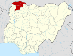
Shagari, Nigeria

Last updated

Shagari
LGA and town
Nigeria location map.svg
Red pog.svg
Shagari
Coordinates: 12°38′N5°0′E / 12.633°N 5.000°E / 12.633; 5.000
CountryFlag of Nigeria.svg  Nigeria
State Sokoto State
Government
  Districts head Muhammad Bala Shagari
Area
  Total514 sq mi (1,332 km2)
Population
 (2006)
  Total156,413
Time zone UTC+1 (WAT)
3-digit postal code prefix
851
ISO 3166 code NG.SO.SH
Shagari, Nigeria

Shagari is a Local Government Area in Sokoto State, Nigeria. Its headquarters are in the town of Shagari on the A1 highway. The local government area (LGA) shares a border with Zamfara State in the south.

It has an area of 1,332 km2 and a population of 156,413 at the 2006 census. [1]

The postal code of the area is 851. [2]

Climate

With temperatures ranging from 64°F to 103°F, the climate has two distinct seasons: a scorching, oppressive wet season with mostly cloudy skies, and a scorching, partly cloudy dry season. [3]

Related Research Articles

Kebbe is a Local Government Area in Sokoto State, Nigeria. Its headquarters are in the town of Kebbe. The LGA shares a border with Zamfara State in the east and Kebbi State in the south and west.

Damaturu is a Local Government Area and the capital city of Yobe State in northern Nigeria. It is the headquarters of the Damaturu Emirate.

Rabah is a Local Government Area in Sokoto State, Nigeria. Its headquarters are in the town of Rabah.

<span class="mw-page-title-main">Gboko</span> LGA in Benue state

Gboko is a Local Government Area in Benue state, North-central Nigeria. It is headquartered in the town of Gboko.

Demsa is a Local Government Area of Adamawa State, Nigeria with headquarters located in Demsa. Demsa lies on the Benue River.

Kwaya Kusar is a Local Government Area of Borno State, Nigeria. Its headquarters are in the town of Kwaya Kusar.

Guri is a Local Government Area of Jigawa State, Nigeria. Its headquarters are in the town of Guri. [The big town of guri local government is] KADIRA.

Jahun is a Local Government Area of Jigawa State, Nigeria. Its headquarters are in the town of Jahun.

Sule Tankarkar is a Local Government Area in the north of Jigawa State, Nigeria, bordering on the Republic of Niger. Its headquarters is in the town of Sule Tankarkar.

Kaugama is a Local Government Area in the north of Jigawa State, Nigeria. Its headquarters are in the town of Kaugama.

Igalamela-Odolu is a Local Government Area in Kogi State, Nigeria. It is bordered by the Niger River in the west and Enugu State in the east. Its headquarters are in the town of Ajaka in the north of the area at7°10′16″N6°49′35″E.

Omala is a Local Government Area in Kogi State, Nigeria bounded in the north by the Benue River. Its headquarters are in the town of Abejukolo in the north of the area at7°43′N7°33′E.

Augie is a Local Government Area in Kebbi State, Nigeria. Its headquarters are in the town of Augie.

Kankara is a Local government area in Katsina State, Nigeria. Its headquarters is located in the town of Kankara.

Fagge is a Local Government Area in Kano State, Nigeria, within the state metropolitan. Its headquarters are in the suburb of Waje.

Kachia is a Local Government Area in the southern part of Kaduna State, Nigeria. Its headquarters are in the town of Kachia. It has an area of 4,570 km2 and a population of 252,568 in the 2006 census. The postal code of the area is 802.

Kauru is a Local Government Area in southern Kaduna State, Nigeria. The area is 3,186 km2. Its headquarters are in the town of Kauru. The postal code of the area is 811.

Wurno is a Local Government Area in Sokoto State, Nigeria. Its headquarters is in the town of Wurno, near the Gagere River.

Gwadabawa is a Local Government Area in Sokoto State, Nigeria. Its headquarters are in the town of Gwadabawa on the A1 highway. It comprises Gwadabawa, Salame, Chimola and Asara districts

Yabo is a Local Government Area in Sokoto State, Nigeria. Its headquarters is in the town of Yabo, and Yabo local Government is one of the oldest local governments in Sokoto. Since Sokoto, Kebbi and Zamfara are known as Sokoto. by then Yabo, Tambuwal and Shagari are all known as Yabo local government.

References

  1. HASC, population, area and Headquarters Statoids
  2. "Post Offices- with map of LGA". NIPOST. Archived from the original on 2012-11-26. Retrieved 2009-10-20.
  3. "Shagari Climate, Weather By Month, Average Temperature (Nigeria) - Weather Spark". weatherspark.com. Retrieved 2023-09-01.