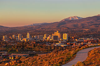
Reno is a city in the northwest section of the U.S. state of Nevada, along the Nevada–California border. It is the county seat and most populous city of Washoe County. Sitting in the High Eastern Sierra foothills, in the Truckee River valley, on the eastern side of the Sierra Nevada, it is about 23 miles (37 km) northeast of Lake Tahoe. Known as "The Biggest Little City in the World", Reno is the 80th most populous city in the United States, the fourth most populous city in Nevada, and the most populous in Nevada outside the Las Vegas Valley. The city had a population of 264,165 at the 2020 census.

U.S. Route 395, also known as U.S. Highway 395, is a north–south United States Numbered Highway that traverses the inland areas of the western states of California, Nevada, Oregon, and Washington. It travels for over 1,300 miles (2,100 km) from a junction in the Mojave Desert at Interstate 15 (I-15) in Hesperia to the Canada–U.S. border near Laurier, Washington. Major cities along its route include Carson City and Reno in Nevada; Kennewick and Pasco in Washington's Tri-Cities region; and Spokane, Washington. US 395 is an auxiliary route of US 95 but never intersects its parent route, which runs further east.

Dillard's, Inc. is an American department store chain with approximately 267 stores in 29 states and headquartered in Little Rock, Arkansas. Currently, the largest number of stores are located in Texas with 57 and Florida with 42. The company also has stores in 27 more states; however, it is absent from the Northeast, most of the Upper Midwest, and most of the West Coast, aside from three stores in California.

Interstate 580 (I-580) is a 35.019-mile (56.358 km) auxiliary Interstate Highway in Western Nevada. It runs concurrently with US Route 395 (US 395) from an intersection with US 50 near the southern boundary of Carson City to the Reno Spaghetti Bowl interchange with I-80 in Reno. The freeway provides a high-speed direct route between Lake Tahoe and Carson City to Reno and I-80.
Sierra Highway or El Camino Sierra is a road in Southern California, United States. El Camino Sierra refers to the full length of a trail formed in the 19th century, rebuilt as highways in the early 20th century, that ran from Los Angeles to Lake Tahoe following parts of modern State Route 14, U.S. Route 395 and State Route 89. Two portions of this road are currently signed as Sierra Highway. The first is an old alignment of SR 14/U.S. Route 6 from Los Angeles to Mojave. This road is also signed with the unusual designation of State Route 14U through the city of Santa Clarita. The second part signed as Sierra Highway is a portion of US 395 in Bishop.

Interstate 80 (I-80) traverses the northern portion of the US state of Nevada. The freeway serves the Reno metropolitan area and passes through the towns of Fernley, Lovelock, Winnemucca, Battle Mountain, Carlin, Elko, Wells, and West Wendover on its way through the state.

Summit Mall is a one-story, 850,000-square-foot (79,000 m2) enclosed shopping mall located at 3265 W. Market Street in the Akron suburb of Fairlawn., and with the closing of both Chapel Hill Mall and Rolling Acres Mall, is the only remaining mall in Summit County.

Galena is an abandoned town in Washoe County, Nevada, south of Reno. The portion of Reno just south of Mount Rose Highway and west of Steamboat Springs is also known as Galena.

Mall St. Matthews, formerly known as The Mall, is a shopping mall located near Louisville, Kentucky at 5000 Shelbyville Road in the eastern suburb of St. Matthews.

State Route 431, commonly known as the Mount Rose Highway, is a 24.413-mile-long (39.289 km) highway in Washoe County, Nevada, that connects Incline Village at Lake Tahoe with Reno. The highway, a Nevada Scenic Byway, takes its name from Mount Rose, which lies just off the highway. Prior to 1976, the highway existed as State Route 27.
Park Plaza Mall is an enclosed shopping mall located in the Midtown neighborhood of Little Rock, Arkansas. Originally opened in 1960 as Park Plaza Shopping Center, an open-air shopping center, the mall is home to two Dillard's flagship stores and merchants including H&M, Talbots, and Eddie Bauer. The structure contains 545,800 square feet (50,710 m2) of retail space, although Dillard's owns 284,165 square feet (26,399.8 m2) of that area for its flagship stores.

U.S. Route 395 (US 395) is a United States Numbered Highway, stretching from Hesperia, California to the Canadian border in Laurier, Washington. The California portion of US 395 is a 557-mile (896 km) route which traverses from Interstate 15 (I-15) in Hesperia, north to the Oregon state line in Modoc County near Goose Lake. The route clips into Nevada, serving the cities Carson City and Reno, before returning to California.

Mount Rose is the highest mountain in Washoe County, within the Carson Range of Nevada, United States. It ranks thirty-seventh among the most topographically prominent peaks in the state. It is also both the highest and most topographically prominent peak of the greater Sierra Nevada range within the state of Nevada, and the third most topographically prominent peak in the Sierra Nevada overall. It is located in the Mount Rose Wilderness of the Humboldt-Toiyabe National Forest. An extinct volcano, the mountain is in between Lake Tahoe and Reno. State Route 431 traverses Mount Rose Summit southeast of Mount Rose. Due to the high elevation, most of the precipitation that falls on the mountain is snow. The view from Mount Rose facing east is the Truckee Meadows, the second largest population center in Nevada.
U.S. Route 395 (US 395) is an 85-mile-long (137 km) United States Numbered Highway near Lake Tahoe in the state of Nevada. It traverses the state after entering from California in Topaz Lake and crosses back into California near Hallelujah Junction. US 395 serves the cities of Gardnerville, Minden, Carson City and Reno. All of US 395 north of Carson City is a freeway and is built up to Interstate Highway standards. Part of the freeway section is also designated as Interstate 580 (I-580). US 395 is an important regional highway, serving the communities of Western Nevada, connecting them to other major communities via California, and it is the only major north–south arterial for the geographically isolated region.
U.S. Route 395 Business is a north–south state highway in Reno, Nevada. The highway follows Virginia Street, the primary north–south arterial street of the area. US 395 is also designated as State Route 430 (SR 430) from its intersection with SR 659 to its northern terminus at US 395.

The Washoe Valley is a geographical region in the United States covering 66 square miles (170 km2) in southern Washoe County in the state of Nevada. Located between Reno and Carson City, it is named for the Washoe people, Native Americans who lived there before the arrival of Europeans. Slide Mountain and Mount Rose overlook the valley from the west.
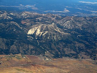
Slide Mountain is a 9,702-foot (2,957 m) peak in the Carson Range near Reno, in Washoe County, Nevada. From the summit of Slide Mountain, Lake Tahoe, Washoe Lake, Carson Valley, and the city of Reno can be viewed.
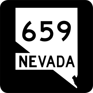
State Route 659 is a state highway in Washoe County, Nevada. The route follows McCarran Boulevard, an arterial ring road serving the cities of Reno and Sparks. The route provides access to many businesses and residential areas in the Truckee Meadows.
U.S. Route 395 Alternate is a 20.082-mile-long (32.319 km) alternate route of U.S. Route 395 in Washoe County, Nevada.
