Sheeted dyke complex

Last updated

Sheeted dykes in exposed ophiolite (the Lizard complex in Cornwall, England) Sheeted Dykes - Anne Burgess.jpg
Sheeted dykes in exposed ophiolite (the Lizard complex in Cornwall, England)

A sheeted dyke complex, or sheeted dike complex, is a series of sub-parallel intrusions of igneous rock, forming a layer within the oceanic crust. [1] At mid-ocean ridges, dykes are formed when magma beneath areas of tectonic plate divergence travels through a fracture in the earlier formed oceanic crust, feeding the lavas above and cooling below the seafloor forming upright columns of igneous rock. Magma continues to cool, as the existing seafloor moves away from the area of divergence, and additional magma is intruded and cools. In some tectonic settings slices of the oceanic crust are obducted (emplaced) upon continental crust, forming an ophiolite. [1] [2] [3]

Contents

Geometry

Cartoon to explain how one-sided chilled margins develop in sheeted dyke complexes from repeated intrusion at one location - four stages of intrusion are shown, with 1 being the earliest Chilled margins.png
Cartoon to explain how one-sided chilled margins develop in sheeted dyke complexes from repeated intrusion at one location - four stages of intrusion are shown, with 1 being the earliest

The individual dykes typically range in thickness from a few centimetres to a few metres. Most of the dykes show evidence of one-sided chilled margins, consistent with most dykes having been split by later dykes. It is also common for the chilled margins to be consistently on one side, suggesting that most dykes in any one exposure were gradually moved away from the spreading centre by further stages of intrusion in a constant location. [4]

The layer of sheeted dykes that makes up the lower part of Layer 2 of the oceanic crust is typically between one and two kilometres thick. At the top, the dykes become increasingly separated by screens of lava, while at the base they become separated by screens of gabbro.

Dyke formation

Magma rises through oceanic crust at mid-ocean ridges Mid-ocean ridge cut away view.png
Magma rises through oceanic crust at mid-ocean ridges

Sheeted dyke complexes are most commonly found at divergent plate boundaries marked by the presence of mid-ocean ridges. These subaqueous mountain ranges are made up of newly created oceanic crust due to tectonic plates moving away from each other. In response to the separation of plates, magma from the asthenosphere is subject to upwelling, pushing hot magma up towards the seafloor. The magma that reaches the surface is subject to fast cooling and creates basaltic formations such as pillow lava, a common extrusive rock created near areas of volcanic activity on the seafloor. [3] Although some magma is able to reach the surface of oceanic crust, a considerable amount of magma solidifies within the crust. Dykes are formed when the rising magma that does not reach the surface cools into upright columns of igneous rock beneath areas of divergence.

Ophiolites

Dykes are perpetually formed as long as magma continues to flow through the plate boundary, creating a distinct, stratigraphic-like sequences of rocky columns within the seafloor. Ophiolites are formed when these sections of oceanic crust are revealed above sea level and embedded within continental crust. [5]

Seafloor spreading and continental drift

(Top) Creation of rift valley due to low spreading rate. (Middle and bottom) Creation of mid-ocean ridges due to higher spreading rate. Ocean-birth.svg
(Top) Creation of rift valley due to low spreading rate. (Middle and bottom) Creation of mid-ocean ridges due to higher spreading rate.

The creation of sheeted dykes is a perpetual and continuous process that promotes the phenomenon known as seafloor spreading. [6] Seafloor spreading is the creation of new oceanic crust by volcanic activity at mid-ocean ridges, and as magma continues to rise and solidify at mid-ocean ridges, the existing older dykes are pushed out of the way to make room for newer seabed. [5] The rate at which new oceanic crust is created is referred to as spreading rate, and variations in spreading rate determine the geometry of the mid-ocean ridge being created at plate boundaries.

Fast-spreading ridges

Mid-ocean ridges with a spreading rate greater than or equal to 90 mm/year are considered to be fast-spreading ridges. Due to the large amounts magma being expelled from the asthenosphere in a relatively short period of time, these formations typically protrude much higher from the seafloor. [7]

Slow-spreading ridges

Mid-ocean ridges with a spreading rate less than or equal to 40 mm/year are considered to be slow-spreading ridges. These formations are typically characterized by a large depression in the seafloor, known as rift valleys, and are formed due to the lack of magma present to solidify. [7]

Examples

Related Research Articles

<span class="mw-page-title-main">Gabbro</span> Coarse-grained mafic intrusive rock

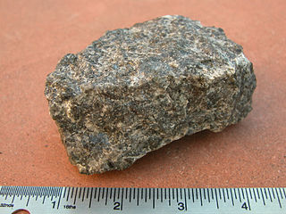
Gabbro is a phaneritic (coarse-grained), mafic intrusive igneous rock formed from the slow cooling of magnesium-rich and iron-rich magma into a holocrystalline mass deep beneath the Earth's surface. Slow-cooling, coarse-grained gabbro is chemically equivalent to rapid-cooling, fine-grained basalt. Much of the Earth's oceanic crust is made of gabbro, formed at mid-ocean ridges. Gabbro is also found as plutons associated with continental volcanism. Due to its variant nature, the term gabbro may be applied loosely to a wide range of intrusive rocks, many of which are merely "gabbroic". By rough analogy, gabbro is to basalt as granite is to rhyolite.

<span class="mw-page-title-main">Pillow lava</span> Lava containing characteristic pillow-shaped structures due to subaqueous extrusion

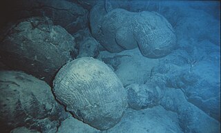
Pillow lavas are lavas that contain characteristic pillow-shaped structures that are attributed to the extrusion of the lava underwater, or subaqueous extrusion. Pillow lavas in volcanic rock are characterized by thick sequences of discontinuous pillow-shaped masses, commonly up to one meter in diameter. They form the upper part of Layer 2 of normal oceanic crust.

<span class="mw-page-title-main">Volcanism</span> Eruption of molten rock onto Earths surface

Volcanism, vulcanism or volcanicity is the phenomenon of eruption of molten rock (magma) onto the surface of the Earth or a solid-surface planet or moon, where lava, pyroclastics, and volcanic gases erupt through a break in the surface called a vent. It includes all phenomena resulting from and causing magma within the crust or mantle of the body, to rise through the crust and form volcanic rocks on the surface. Magmas that reach the surface and solidify form extrusive landforms.

Obduction is a geological process whereby denser oceanic crust is scraped off a descending ocean plate at a convergent plate boundary and thrust on top of an adjacent plate. When oceanic and continental plates converge, normally the denser oceanic crust sinks under the continental crust in the process of subduction. Obduction, which is less common, normally occurs in plate collisions at orogenic belts or back-arc basins.

<span class="mw-page-title-main">Ophiolite</span> Uplifted and exposed oceanic crust

An ophiolite is a section of Earth's oceanic crust and the underlying upper mantle that has been uplifted and exposed, and often emplaced onto continental crustal rocks.

<span class="mw-page-title-main">Dike (geology)</span> A sheet of rock that is formed in a fracture of a pre-existing rock body

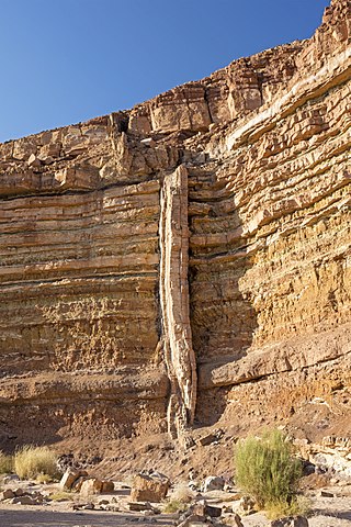
In geology, a dike or dyke is a sheet of rock that is formed in a fracture of a pre-existing rock body. Dikes can be either magmatic or sedimentary in origin. Magmatic dikes form when magma flows into a crack then solidifies as a sheet intrusion, either cutting across layers of rock or through a contiguous mass of rock. Clastic dikes are formed when sediment fills a pre-existing crack.

<span class="mw-page-title-main">Oceanic crust</span> Uppermost layer of the oceanic portion of a tectonic plate

Oceanic crust is the uppermost layer of the oceanic portion of the tectonic plates. It is composed of the upper oceanic crust, with pillow lavas and a dike complex, and the lower oceanic crust, composed of troctolite, gabbro and ultramafic cumulates. The crust overlies the rigid uppermost layer of the mantle. The crust and the rigid upper mantle layer together constitute oceanic lithosphere.

<span class="mw-page-title-main">Sill (geology)</span> Tabular intrusion between older layers of rock

In geology, a sill is a tabular sheet intrusion that has intruded between older layers of sedimentary rock, beds of volcanic lava or tuff, or along the direction of foliation in metamorphic rock. A sill is a concordant intrusive sheet, meaning that it does not cut across preexisting rock beds. Stacking of sills builds a sill complex and a large magma chamber at high magma flux. In contrast, a dike is a discordant intrusive sheet, which does cut across older rocks. Sills are fed by dikes, except in unusual locations where they form in nearly vertical beds attached directly to a magma source. The rocks must be brittle and fracture to create the planes along which the magma intrudes the parent rock bodies, whether this occurs along preexisting planes between sedimentary or volcanic beds or weakened planes related to foliation in metamorphic rock. These planes or weakened areas allow the intrusion of a thin sheet-like body of magma paralleling the existing bedding planes, concordant fracture zone, or foliations.

<span class="mw-page-title-main">Large igneous province</span> Huge regional accumulation of igneous rocks

A large igneous province (LIP) is an extremely large accumulation of igneous rocks, including intrusive and extrusive, arising when magma travels through the crust towards the surface. The formation of LIPs is variously attributed to mantle plumes or to processes associated with divergent plate tectonics. The formation of some of the LIPs in the past 500 million years coincide in time with mass extinctions and rapid climatic changes, which has led to numerous hypotheses about causal relationships. LIPs are fundamentally different from any other currently active volcanoes or volcanic systems.

<span class="mw-page-title-main">Rock cycle</span> Transitional concept of geologic time

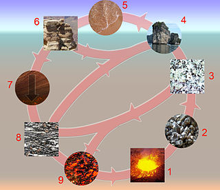
The rock cycle is a basic concept in geology that describes transitions through geologic time among the three main rock types: sedimentary, metamorphic, and igneous. Each rock type is altered when it is forced out of its equilibrium conditions. For example, an igneous rock such as basalt may break down and dissolve when exposed to the atmosphere, or melt as it is subducted under a continent. Due to the driving forces of the rock cycle, plate tectonics and the water cycle, rocks do not remain in equilibrium and change as they encounter new environments. The rock cycle explains how the three rock types are related to each other, and how processes change from one type to another over time. This cyclical aspect makes rock change a geologic cycle and, on planets containing life, a biogeochemical cycle.

<span class="mw-page-title-main">Passive margin</span> Transition between oceanic and continental lithosphere that is not an active plate margin

A passive margin is the transition between oceanic and continental lithosphere that is not an active plate margin. A passive margin forms by sedimentation above an ancient rift, now marked by transitional lithosphere. Continental rifting forms new ocean basins. Eventually the continental rift forms a mid-ocean ridge and the locus of extension moves away from the continent-ocean boundary. The transition between the continental and oceanic lithosphere that was originally formed by rifting is known as a passive margin.

<span class="mw-page-title-main">Harzburgite</span> Ultramafic mantle rock


Harzburgite, an ultramafic, igneous rock, is a variety of peridotite consisting mostly of the two minerals olivine and low-calcium (Ca) pyroxene (enstatite); it is named for occurrences in the Harz Mountains of Germany. It commonly contains a few percent chromium-rich spinel as an accessory mineral. Garnet-bearing harzburgite is much less common, found most commonly as xenoliths in kimberlite.

<span class="mw-page-title-main">Magmatism</span> Emplacement of magma on the outer layers of a terrestrial planet, which solidifies as igneous rocks

Magmatism is the emplacement of magma within and at the surface of the outer layers of a terrestrial planet, which solidifies as igneous rocks. It does so through magmatic activity or igneous activity, the production, intrusion and extrusion of magma or lava. Volcanism is the surface expression of magmatism.

<span class="mw-page-title-main">North Atlantic Igneous Province</span> Large igneous province in the North Atlantic, centered on Iceland

The North Atlantic Igneous Province (NAIP) is a large igneous province in the North Atlantic, centered on Iceland. In the Paleogene, the province formed the Thulean Plateau, a large basaltic lava plain, which extended over at least 1.3 million km2 (500 thousand sq mi) in area and 6.6 million km3 (1.6 million cu mi) in volume. The plateau was broken up during the opening of the North Atlantic Ocean leaving remnants preserved in north Ireland, west Scotland, the Faroe Islands, northwest Iceland, east Greenland, western Norway and many of the islands located in the north eastern portion of the North Atlantic Ocean. The igneous province is the origin of the Giant's Causeway and Fingal's Cave. The province is also known as Brito–Arctic province and the portion of the province in the British Isles is also called the British Tertiary Volcanic Province or British Tertiary Igneous Province.

Volcanic passive margins (VPM) and non-volcanic passive margins are the two forms of transitional crust that lie beneath passive continental margins that occur on Earth as the result of the formation of ocean basins via continental rifting. Initiation of igneous processes associated with volcanic passive margins occurs before and/or during the rifting process depending on the cause of rifting. There are two accepted models for VPM formation: hotspots/mantle plumes and slab pull. Both result in large, quick lava flows over a relatively short period of geologic time. VPM's progress further as cooling and subsidence begins as the margins give way to formation of normal oceanic crust from the widening rifts.

<span class="mw-page-title-main">Igneous rock</span> Rock formed through the cooling and solidification of magma or lava

Igneous rock, or magmatic rock, is one of the three main rock types, the others being sedimentary and metamorphic. Igneous rocks are formed through the cooling and solidification of magma or lava.

The Troodos Ophiolite on the island of Cyprus represents a Late Cretaceous spreading axis that has since been uplifted due to its positioning on the overriding Anatolian plate at the Cyprus arc and ongoing subduction to the south of the Eratosthenes Seamount.

<span class="mw-page-title-main">Samail Ophiolite</span>

The Samail Ophiolite (also spelled Semail Ophiolite) of the Hajar Mountains of Oman and the United Arab Emirates is a large slab of oceanic crust, made of volcanic rocks and ultramafic rocks from the Earth's upper mantle, that was overthrust onto continental crust as an ophiolite. It is located on the eastern corner of the Arabian Peninsula and covers an area of approximately 100,000 km2. Based on uranium-lead dating techniques, the Samail Ophiolite formed in the Late Cretaceous. It is primarily made of silicate rocks with (SiO2) content ranging from 45–77 wt%. The Samail Ophiolite is important because it is rich in copper and chromite ore bodies, and because it also provides valuable information about the ocean floor and the upper mantle on land. Geologists have studied the area, attempting to find the best model explaining the formation of the Samail Ophiolite.

The lower oceanic crust is the lower part of the oceanic crust and represents the major part of it. It is generally located 4–8 km below the ocean floor and the major lithologies are mafic which derive from melts rising from the Earth's mantle. This part of the oceanic crust is an important zone for processes such as melt accumulation and melt modification. And the recycling of this part of the oceanic crust, together with the upper mantle has been suggested as a significant source component for tholeiitic magmas in Hawaiian volcanoes. Although the lower oceanic crust builds the link between the mantle and the MORB, and can't be neglected for the understanding of MORB evolution, the complex processes operating in this zone remain unclear and there is an ongoing debate in Earth Sciences about this. It is 6KM long.

<span class="mw-page-title-main">Chile Ridge</span> Submarine oceanic ridge in the Pacific Ocean

The Chile Ridge, also known as the Chile Rise, is a submarine oceanic ridge formed by the divergent plate boundary between the Nazca Plate and the Antarctic Plate. It extends from the triple junction of the Nazca, Pacific, and Antarctic plates to the Southern coast of Chile. The Chile Ridge is easy to recognize on the map, as the ridge is divided into several segmented fracture zones which are perpendicular to the ridge segments, showing an orthogonal shape toward the spreading direction. The total length of the ridge segments is about 550–600 km.

References

  1. 1 2 Phillips-Lander, Charity M.; Dilek, Yildirim (March 2009). "Structural architecture of the sheeted dike complex and extensional tectonics of the Jurassic Mirdita ophiolite, Albania". Lithos. 108 (1–4): 192–206. Bibcode:2009Litho.108..192P. doi:10.1016/j.lithos.2008.09.014.
  2. Karson, Jeffrey A. (2019). "From Ophiolites to Oceanic Crust: Sheeted Dike Complexes and Seafloor Spreading". In Srivastava, R.; Ernst, R.; Peng, P. (eds.). Dyke Swarms of the World: A Modern Perspective. Springer Geology. Singapore: Springer. pp. 459–492. doi:10.1007/978-981-13-1666-1_13. ISBN   978-981-13-1665-4.
  3. 1 2 Schmincke, Hans-Ulrich (2004). Volcanism. New York: Springer-Verlag. pp. 61–62. ISBN   3-540-43650-2.
  4. Hutton, D.H.W.; Aftalion, M.; Halliday, A.N. (1985). "An Ordovician ophiolite in County Tyrone, Ireland". Nature. 315: 210–212. doi:10.1038/315210a0.
  5. 1 2 Robinson, Paul T.; Malpas, John; Dilek, Yildirim; Zhou, Mei-fu (2008). "The significance of sheeted dike complexes in ophiolites". GSA Today. 18 (11): 4. doi: 10.1130/GSATG22A.1 .
  6. Karson, Jeffrey A.; Hurst, Stephen D.; Lonsdale, Peter (1992). "Tectonic rotations of dikes in fast-spread oceanic crust exposed near Hess Deep". Geology. 20 (8): 685. Bibcode:1992Geo....20..685K. doi:10.1130/0091-7613(1992)020<0685:TRODIF>2.3.CO;2.
  7. 1 2 Marinoni, Laura B (June 2001). "Crustal extension from exposed sheet intrusions: review and method proposal". Journal of Volcanology and Geothermal Research. 107 (1–3): 27–46. Bibcode:2001JVGR..107...27M. doi:10.1016/S0377-0273(00)00318-8.
  8. Mackenzie, G.D.; Maguire, P.K.H.; Coogan, L.A.; Khan, M.A.; Eaton, M.; Petrides, G. (2006). "Geophysical constraints on the crustal architecture of the Troodos ophiolite: results from the IANGASS project". Geophys. J. Int. 167: 1385–1401. doi: 10.1111/j.1365-246X.2006.03144.x .
  9. Rothery, D. A. (March 1983). "The base of a sheeted dyke complex, Oman ophiolite: implications for magma chambers at oceanic spreading axes". Journal of the Geological Society. 140 (2): 287–296. Bibcode:1983JGSoc.140..287R. doi:10.1144/gsjgs.140.2.0287.
  10. Nicolas, A.; Boudier, F. (1991). "Rooting of the Sheeted Dike Complex in the Oman Ophiolite". Ophiolite Genesis and Evolution of the Oceanic Lithosphere. Petrology and Structural Geology. Vol. 5. pp. 39–54. doi:10.1007/978-94-011-3358-6_4. ISBN   978-94-010-5484-3.
  11. Kelley, Deborah S.; Vanko, David A.; Gu, Chifeng (1995). "Fluid evolution in oceanic crustal layer 2: fluid inclusion evidence from the sheeted dike complex, Hole 504B, Costa Rica Rift". Proceedings of the Ocean Drilling Program, Scientific Results. Proceedings of the Ocean Drilling Program. 137/140: 191–198. doi: 10.2973/odp.proc.sr.137140.015.1995 .