
Mudflats or mud flats, also known as tidal flats or, in Ireland, slob or slobs, are coastal wetlands that form in intertidal areas where sediments have been deposited by tides or rivers. A global analysis published in 2019 suggested that tidal flat ecosystems are as extensive globally as mangroves, covering at least 127,921 km2 (49,391 sq mi) of the Earth's surface. They are found in sheltered areas such as bays, bayous, lagoons, and estuaries; they are also seen in freshwater lakes and salty lakes alike, wherein many rivers and creeks end. Mudflats may be viewed geologically as exposed layers of bay mud, resulting from deposition of estuarine silts, clays and aquatic animal detritus. Most of the sediment within a mudflat is within the intertidal zone, and thus the flat is submerged and exposed approximately twice daily.

Western Port, commonly but unofficially known as Western Port Bay, is a large tidal bay in southern Victoria, Australia, opening into Bass Strait. It is the second largest bay in the state. Geographically, it is dominated by two large islands; French Island and Phillip Island. At the time it was renamed, its position was west of other known ports and bays, but Western Port has become something of a misnomer as it lies just to the east of the larger Port Phillip and the city of Melbourne. It is visited by Australian fur seals, whales and dolphins, as well as many migratory waders and seabirds. It is listed under the Ramsar Convention as a wetland of international significance.

Roebuck Bay is a bay on the coast of the Kimberley region of Western Australia. Its entrance is bounded in the north by the town of Broome, and in the south by Bush Point and Sandy Point. It is named after HMS Roebuck, the ship captained by William Dampier when he explored the coast of north-western Australia in 1699. The Broome Bird Observatory lies on the northern coast of the bay.

Shoalwater Bay Military Training Area is a heritage-listed military installation at Byfield Road, Byfield, Shire of Livingstone, Queensland, Australia. It is a large, relatively undisturbed and intact natural system with a wide variety of coastal landforms and a high level of biodiversity. It contains a diverse range of marine and coastal wetland landscapes, vegetation types and ecosystems. It was added to the Australian Commonwealth Heritage List on 22 June 2004.

The Barker Inlet is a tidal inlet of the Gulf St Vincent in Adelaide, South Australia, named after Captain Collet Barker who first sighted it in 1831. It contains one of the southernmost mangrove forests in the world, a dolphin sanctuary, seagrass meadows and is an important fish and shellfish breeding ground. The inlet separates Torrens Island and Garden Island from the mainland to the east, and is characterised by a network of tidal creeks, artificially deepened channels, and wide mudflats. The extensive belt of mangroves are bordered by samphire saltmarsh flats and low-lying sand dunes.
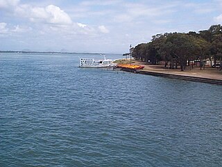
Pumicestone Channel, also known as the Pumicestone Passage, is a narrow waterway between Bribie Island and the mainland in Queensland, Australia. The northern extent of the passage is at Caloundra, while at the south is Deception Bay. The waterway is a two way tidal estuary that has 11 creeks flowing into it. At each end of the passage the channels are the deepest and widest.

The Mary River flows in the Northern Territory of Australia and is a site of the Mary River National Park.

The Corner Inlet is a 600-square-kilometre (230 sq mi) bay located 200 kilometres (120 mi) south-east of Melbourne in the South Gippsland region of Victoria, Australia. Of Victoria's large bays it is both the easternmost and the warmest. It contains intertidal mudflats, mangroves, salt marsh and seagrass meadows, sheltered from the surf of Bass Strait by a complex of 40 sandy barrier islands, the largest of which are Snake, Sunday and Saint Margaret Islands.

Anderson Inlet, sometimes incorrectly referred to as Andersons Inlet, is a shallow and dynamic estuary in South Gippsland, Victoria, Australia where the Tarwin River enters Bass Strait. It forms a 2,400-hectare (5,900-acre) almost enclosed bay next to the town of Inverloch, for which it provides a popular and protected beach. At low tide its intertidal mudflats provide important feeding habitat for migratory waders. It is also an important area for recreational fishing. It is named after Samuel Anderson pioneer explorer the first European to settle in the area.

Australia has approximately 11,500 km2 of mangroves, primarily on the northern and eastern coasts of the continent. Areas where mangroves occur include the intertidal zone of tropical, subtropical and protected temperate coastal rivers, estuaries, bays and marine shorelines. Less than 1% of Australia's total forest area is mangrove forest.
Blue Mud Bay is a large, shallow, partly enclosed bay on the eastern coast of Arnhem Land, in the Northern Territory of Australia, facing Groote Eylandt on the western side of the Gulf of Carpentaria. It lies 580 km (360 mi) east-south-east of Darwin in the Arnhem Coast bioregion. Its name was given to a landmark court ruling affirming that the Aboriginal traditional owners of much of the Northern Territory's coastline have exclusive rights over commercial and recreational fishing in tidal waters overlying their land.
Buckingham Bay is a large, rectangular bay on the northern coast of Arnhem Land, in the Northern Territory of Australia. It lies 520 km east of Darwin and 120 km west of Nhulunbuy.

Limmen Bight is a bight, or large, open bay, located in the Northern Territory of Australia at the western end of the Gulf of Carpentaria about 360 kilometres (220 mi) east of the town of Katherine. It is part of the traditional lands and waters of the Marra people. It was named in April 1644 by Abel Tasman for one of his ships on his voyage of exploration along the northern Australian coast. It contains the second largest area of tidal flats in the Northern Territory.

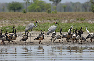
The Fog Bay and Finniss River Floodplains comprise the floodplain of the lower reaches of the Finniss River with the adjoining intertidal mudflats of Fog Bay in the Top End of the Northern Territory of Australia. It is an important site for waterbirds.
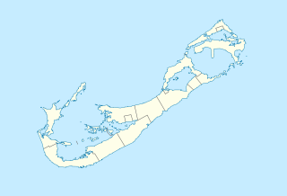
Hungry Bay Nature Reserve is a nature reserve on the east coast of Bermuda. It was established in 1986. It is considered the best example of coastal mangrove swamp on the island. It includes the Hungry Bay area and the largest mangrove coastal swamp in Bermuda. It is protected by a Tree preservation order (T.P.O.) and designated as an official Nature Reserve within the Parks system of Bermuda.

The Wildman River is a river in the Darwin Coastal bioregion of the Northern Territory, Australia.
Shoal Bay Coastal Reserve is a protected area in the Northern Territory of Australia.
Liverpool River is a river in the Northern Territory of Australia. It is the largest of the tidal river systems of northern Arnhem Land, which includes two major tributaries, the Tomkinson and Mann Rivers.
The Moyle River is a river in the Northern Territory, Australia.
Wide Bay Military Reserve is a heritage-listed military installation at Tin Can Bay Road, Tin Can Bay, Queensland, Australia. The reserve supports a diverse range of plant communities from estuarine, strand, wetlands, heath, tall shrublands and woodlands, to the open forests of the sub-coastal hills and ranges. The total number of bird species recorded for the place totals 250, which is high by Australian standards. It was added to the Australian Commonwealth Heritage List on 22 June 2004.

