Shpack Landfill

Last updated

Shpack Landfill
Superfund site
Shpack Landfill Federal Superfund Site.jpg
Rusting chemical waste drums at Shpack Landfill site in May 2003.
Geography
Town Norton
County Bristol
State Massachusetts
Coordinates 41°56′36″N71°14′06″W / 41.94333°N 71.23500°W / 41.94333; -71.23500 Coordinates: 41°56′36″N71°14′06″W / 41.94333°N 71.23500°W / 41.94333; -71.23500
USA Massachusetts location map.svg
Red pog.svg
Shpack Landfill
Shpack Landfill's location in Massachusetts
Information
CERCLIS IDMAD980503973
Contaminants
Progress
ProposedOctober 15, 1984
ListedOctober 6, 1986
List of Superfund sites

Shpack Landfill is a hazardous waste site in Norton, Massachusetts. After assessment by the United States Environmental Protection Agency (EPA) it was added to the National Priorities List in October 1986 for long-term remedial action. The site cleanup is directed by the federal Superfund program. [2] The Superfund site covers 9.4 acres, mostly within Norton, with 3.4 acres in the adjoining city of Attleboro. The Norton site was operated as a landfill dump accepting domestic and industrial wastes, including low-level radioactive waste, between 1946 and 1965. [3] [4] [5] The source of most of the radioactive waste, consisting of uranium and radium, was Metals and Controls Inc. which made enriched uranium fuel elements for the U.S. Navy under contract with the U.S. Atomic Energy Commission. Metals and Controls merged with Texas Instruments in 1959. [6] [7] [8] [9] The Shpack landfill operation was shut down by a court order in 1965. [10]

Contents

Geology

The site's geology broadly comprises glacial deposits 4.5–7.6 m (15–25 ft) deep overlying bedrock, with some areas overlain with peat to a depth of 1.5–9.2 m (4.9–30.2 ft). The bedrock was formed during the Triassic-Jurassic period and consists mainly of sandstone, greywacke, shale and conglomerate. Groundwater in the area is produced from both the bedrock and shallow aquifers. [11] [12] The water table is at or near the surface for most of the year, and the area is generally low and swampy. [11]

Geography

The Superfund site consists of 9.4 acres and straddles the border between Norton and Attleboro. Approximately 6.0 acres in Norton were owned by the Shpack family who operated it as a landfill. This land was purchased by the town's Norton Conservation Commission in 1981 in order to facilitate remediation. [7] The adjoining 3.4 acres are located in Attleboro and are part of a separate landfill operation owned by Attleboro Landfill Inc (ALI). The site is mostly level and was formerly a flat wetlands area. The site is bounded in the north by Peckham Street/Union Road, by Chartley Swamp in the south and east, and by the ALI landfill in the west. [13] [14]

History

The Shpack landfill was situated on land owned by Isadore and Lea Shpack. Isadore Shpack, a Russian Jewish immigrant and retired New York City municipal employee, began allowing dumping on the property in an effort to fill in its swamp. He then planned to raise an orchard and cultivate vegetables on the reclaimed land. [7] [15] Shpack allowed completely unregulated dumping and is reported locally to have accepted any type of waste which was refused by the neighbouring municipal landfill. [16]

The ALI landfill was originally Attleboro's municipal dump from the 1940s until 1975. In 1975 it was purchased by Attleboro Landfill Inc. which continued to use it as a landfill until 1995. [17]

Discovery of contamination

In 1978 John Sullivan, a 20-year-old local resident who was also a student at the Florida Institute of Technology, became curious about why snails in the area were losing their shells. He visited the Shpack site with a Geiger counter which detected a high level of radiation emissions. [4] [15] [18] [19] Initially "ridiculed" about his claim of discovering radioactivity at the dump, Sullivan contacted the Nuclear Regulatory Commission (NRC) which then carried out its own investigation and confirmed the presence of radioactivity. [20] The site was found to contain radium-226, radium-228, uranium-235, uranium-236 and uranium-238. [20] The presence of Uranium-236 was indicative of reprocessed reactor fuel being dumped at the site, and testing of Uranium-235 samples demonstrated enrichment as high as 76%. [12] A second survey was conducted in 1980 by Oak Ridge National Laboratory as a result of which the site was designated for remedial action under the U.S. Department of Energy's Formerly Utilized Sites Remedial Action Program (FUSRAP). [12] [14] FUSRAP is used to remediate or control sites "where radioactive contamination remains from the early years of the nation's atomic energy program." [13]

Further surveys of the site uncovered extensive contamination with chemical wastes which had been dumped "in both bulk and containerized forms." The metal drums which originally contained the wastes had been emptied, burned and left on the surface of the site. [12] Contaminants included volatile organic compounds (VOCs), heavy metals (e.g. nickel, cadmium, copper, lead and mercury), dioxins, polychlorinated biphenyls (PCBs) and polycyclic aromatic hydrocarbons (PAHs). [14]

Cleanup action

In 1980 the Department Of Energy conducted an emergency cleanup of the site and removed approximately 900 lb of radioactive waste. [14] In 1986 the site was listed as a Superfund site by the EPA. [7] Further studies of the site were carried out during 1992-1993 although no remediation action took place. [14] During 2000-2002 the U.S. Army Corps of Engineers - which had taken over the FUSRAP program in 1998 - performed "fieldwork" to prepare for a radiological survey and in 2004 the EPA put forward a cleanup plan. The project, estimated to cost $43 million, proposed the removal and disposal of 35,000 yd³ (26,759 m3) of radioactive soil by the Army Corps of Engineers, with a second phase during which the EPA would remove the chemical wastes. [10] Work was expected to begin in early 2005 and be completed by 2006. [21]

Remediation eventually commenced in August 2005 but ceased in July 2006 due to lack of funds. During this time, the Army Corps of Engineers removed 2,700 yd (2,500 m)3) of contaminated soil. [22] [23]

Potentially Responsible Parties

On August 15, 2006, the EPA issued special notice letters to fourteen Potentially Responsible Parties (PRP). [24] A PRP is "any individual or company potentially responsible for, or contributing to a spill or other contamination at a Superfund site." In 2009, the following parties signed a consent decree to undertake remediation at the site: [25]

Under the terms of the decree the PRPs would be responsible for funding the remainder of the cleanup at an estimated cost of $29 million. The Town of Norton would not be held financially liable for cleanup costs, but would instead provide access to the site. [19]

Texas Instruments (TI) subsequently filed a complaint alleging that liability for the disposal of radioactive materials relating to its work for the Atomic Energy Commission was subject to indemnity by the Department of Energy. The U.S. Department of Justice then commenced a lawsuit against TI on behalf of the Corps of Engineers, which TI settled in November 2012. TI agreed to pay $15 million towards remediation of the site, without acknowledging liability. The payment went to the Corps of Engineers. [26]

See also

Related Research Articles

<span class="mw-page-title-main">Superfund</span> US federal program to investigate / clean up sites contaminated with hazardous substances

Superfund is a United States federal environmental remediation program established by the Comprehensive Environmental Response, Compensation, and Liability Act of 1980 (CERCLA). The program is administered by the Environmental Protection Agency (EPA). The program is designed to investigate and clean up sites contaminated with hazardous substances. Sites managed under this program are referred to as "Superfund" sites. There are 40,000 federal Superfund sites across the country, and approximately 1,300 of those sites have been listed on the National Priorities List (NPL). Sites on the NPL are considered the most highly contaminated and undergo longer-term remedial investigation and remedial action (cleanups).

<span class="mw-page-title-main">Weldon Spring Ordnance Works</span>

Weldon Spring Ordnance Works (WSOW) was a 17,323-acre (70.10 km2) U.S. Government-owned, contractor-operated (GOCO) facility in St. Charles County, Missouri, 55 km west of St. Louis. The site was originally operated by the Atlas Powder Company during World War II from 1941 to 1945 to produce explosives. The Atomic Energy Commission acquired part of the property in 1955, and Mallinckrodt, Inc. processed uranium ore from 1957 to 1966 under contract. The site has been divided into several parcels, and ownership has transferred over the years. Two portions of the original WSOW property are now Superfund sites that require substantial cleanup efforts. The environmental remediation of the WSOW site is currently designated as a major project of the Defense Environmental Restoration Program of the United States Department of Defense. Part of the original property is still used by the Army Reserve as the Weldon Spring Training Area.

<span class="mw-page-title-main">Maxey Flats</span> Radioactive waste dump site in Kentucky

The Maxey Flats low-level radioactive waste (LLRW) disposal site is a Superfund site in Kentucky which served as a disposal site for low-level nuclear waste from 1963 to 1977. Investigations by the Environmental Protection Agency, among others, determined that plutonium stored at the site had migrated beyond the site's trenches, and the site was closed in 1977.

<span class="mw-page-title-main">Lake Ontario Ordnance Works</span> Military installation in Niagara County, New York

The former Lake Ontario Ordnance Works (LOOW) was a 7,500-acre (3,000 ha) military installation located in Niagara County, New York, United States, approximately 9.6 mi (15.4 km) north of Niagara Falls.
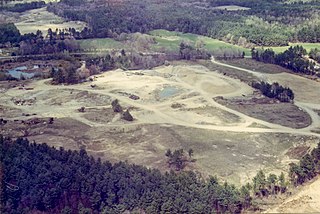
<span class="mw-page-title-main">Midnite Mine</span>

The Midnite Mine is an inactive uranium mine in the Selkirk Mountains of the state of Washington that operated from 1955 to 1965 and again from 1968 to 1981. Located within the reservation of the Spokane Tribe of Indians, it is approximately 8 miles (13 km) from Wellpinit, Stevens County. The mine was listed as a Superfund site under the Comprehensive Environmental Response, Compensation, and Liability Act of 1980 (CERCLA) on May 11, 2000. In addition to elevated levels of radioactivity, heavy metals mobilized in uranium acid mine drainage pose a potential threat to human health and the environment.

<span class="mw-page-title-main">Dorney Road Landfill</span> Superfund site in Pennsylvania

Dorney Road Landfill is a 27-acre municipal and industrial landfill in Upper Macungie Township and Longswamp Township, Pennsylvania that was polluted with toxic waste from 1952 to 1978. The site is surrounded by rural residences and farmland. The U.S. Environmental Protection Agency (EPA) added the site to the Superfund National Priorities List in 1984. The site was remediated and removed from the National Priorities List in 2018.

<span class="mw-page-title-main">Kalamazoo Superfund Site</span>

In 1990, the Allied Paper, Inc./Portage Creek/Kalamazoo River in southwestern Michigan was declared by the Environmental Protection Agency (EPA) to be a Superfund site – in other words, an abandoned industrial site containing significant amounts of toxic waste. The EPA and companies responsible for the waste in this area, which includes a three-mile section of Portage Creek as well as part of the Kalamazoo River, into which it flows, are currently involved in an effort to reduce the amount of toxic waste at the site, which is contaminated by PCBs from paper mills and other factories.

The Lipari Landill is an inactive landfill on a 6-acre (2.4 ha) former gravel pit in Mantua Township, New Jersey. It was used from 1958 to 1971 as a dump site for household and industrial wastes. Toxic organic compounds and heavy metals dumped at the site have percolated into the ground water and leached into lakes and streams in the surrounding area. The site has been identified as the worst toxic dump in the United States and was ranked at the top of the United States Environmental Protection Agency's Superfund eligibility list.

<span class="mw-page-title-main">Uranium mining and the Navajo people</span> Effects of uranium mining on Navajo

In the 1950s, the Navajo Nation was situated directly in the uranium mining belt that experienced a boom in production, and many residents found work in the mines. Prior to 1962, the risks of lung cancer due to uranium mining were unknown to the workers, and the lack of a word for radiation in the Navajo language left the miners unaware of the associated health hazards. The cultural significance of water for the Navajo people and the environmental damage to both the land and livestock inhibits the ability of the Navajo people to practice their culture.

The former Operating Industries Inc. Landfill is a Superfund site located in Monterey Park, California at 900 N Potrero Grande Drive. From 1948 to 1984, the landfill accepted 30 million tons of solid municipal waste and 300 million US gallons (1,100,000 m3) of liquid chemicals. Accumulating over time, the chemical waste polluted the air, leached into groundwater, and posed a fire hazard, spurring severely critical public health complaints. Recognizing OII Landfill's heavy pollution, EPA placed the financial responsibility of the dump's clean-up on the main waste-contributing companies, winning hundreds of millions of dollars in settlements for the protection of human health and the environment.

The Ringwood Mines landfill site is a 500-acre former iron mining site located in the borough of Ringwood, New Jersey. Used in the late 1960s and early 1970s by the large Ford Motor Company plant in nearby Mahwah, New Jersey for disposal of waste, it was identified by the Environmental Protection Agency (EPA) for its Superfund priority list in 1984 for cleanup of hazardous wastes. EPA deleted the site from the Superfund list in 1994 but subsequently relisted the site several times due to failed environmental remediation. Portions of the landfill site were repurposed as land used for affordable housing for the Ramapough people in the 1970s, even though the land was contaminated.

The Ashland/Northern States Power Lakefront Superfund site is a contaminated region of the Wisconsin shoreline of Lake Superior that is being studied for remediation by Northern States Power Wisconsin (NSPW), as well as the Environmental Protection Agency (EPA), the Wisconsin Department of Natural Resources (WDNR). This site has held a manufactured gas plant from 1845 to 1947, as well as lumber manufacturing and treatment mills for four decades at the start of the 20th century, railcar loading facilities, and a municipal landfill. Additionally, a wastewater treatment plant is located on the premises, but is not in operation. Contamination of the site is currently believed to have been caused by all the parties mentioned above, or former owners of the property whose companies are no longer in business. The area is listed as a Superfund site by the EPA under the Comprehensive Environmental Response, Compensation, and Liability Act (CERCLA). Releases of hazardous substances occurred onshore and migrated into sediment in Chequamagon Bay on Lake Superior.

<span class="mw-page-title-main">West Lake Landfill</span> EPA superfund site in Missouri, US

West Lake Landfill is a closed, unlined mixed-waste landfill located in Bridgeton, Missouri. It was featured in the 2015 documentaries The First Secret City, The Safe Side of the Fence and the 2017 HBO documentary Atomic Homefront. Its contents have been shown to include radioactive waste; it is thus also an EPA Superfund cleanup site.
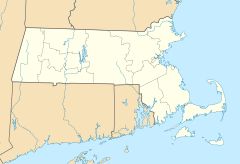
<span class="mw-page-title-main">Moyer's Landfill</span>

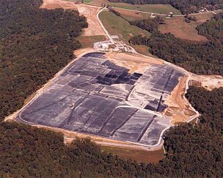
Moyer's Landfill was a privately owned landfill in Collegeville, Pennsylvania, United States. It was originally farmland outside the town. In the 1940s, the owner started accepting trash and municipal waste as a way to make additional money. The original landfill was 39 acres and did not have a liner to protect the land from contaminate. A liner was added to a new section in the late 1970s. Over time, the landfill accepted sewage, and industrial wastes which contained hazardous substances in addition to municipal waste. The site was closed by the EPA in 1981, and was one of the first "Superfund" sites added to the National Priorities List.

Coldwater Creek is a 19-mile tributary of the Missouri River in north St. Louis County in the U.S. state of Missouri. It is known to be contaminated with radioactive wastes.

Guam v. United States, 593 U.S. ___ (2021), was a U.S. Supreme Court case dealing with a dispute on fiscal responsibility for environmental and hazardous cleanup of the Ordot Dump created by the United States Navy on the island of Guam in the 1940s, which Guam then ran after becoming a territory in 1950 until the landfill's closure in 2011. The Supreme Court ruled unanimously that under the Comprehensive Environmental Response, Compensation, and Liability Act of 1980, Guam had filed its lawsuit to recover a portion of cleanup costs for the landfill from the United States government in a timely manner, allowing their case to proceed.

References

  1. "Contaminants of Concern at Shpack Landfill". Superfund Information Systems. United States Environmental Protection Agency. April 19, 2013. Retrieved April 21, 2013.
  2. "Shpack Landfill". Superfund Site Progress Profile. United States Environmental Protection Agency. April 19, 2013. Retrieved April 21, 2013.
  3. "Shpack Landfill, Attleboro and Norton, Massachusetts". Waste Site Cleanup & Reuse in New England. United States Environmental Protection Agency. June 6, 2011. Retrieved April 21, 2013.
  4. 1 2 Preer, Robert (September 23, 2001). "Dispute On Responsibility Halts Cleanup". The Boston Globe . Boston, MA. Archived from the original on March 1, 2016. Retrieved April 21, 2013.  via  Highbeam Research (subscription required)
  5. "Shpack Landfill" (PDF). EPA Superfund Record of Decision. United States Environmental Protection Agency. September 30, 2004. Retrieved April 21, 2013.
  6. Foster, Rick (October 10, 2010). "Our nuclear legacy". The Sun Chronicle . Attleboro, MA. Retrieved April 22, 2013.
  7. 1 2 3 4 Preer, Robert (September 23, 2001). "Neighbors Still Waiting For Cleanup Of Landfill: Work Was Halted Over Dispute On Responsibility". The Boston Globe . Boston, MA. Archived from the original on September 24, 2015. Retrieved April 21, 2013.  via  Highbeam Research (subscription required)
  8. Massey, Joanna (January 25, 2004). "Norton Leaders Upset At US Delay On Cleanup: Agencies Called Uncoordinated". The Boston Globe . Boston, MA. Archived from the original on September 24, 2015. Retrieved April 21, 2013.  via  Highbeam Research (subscription required)
  9. "Shpack Landfill (State of Massachusetts)". Sites Undergoing Decommissioning. Nuclear Regulatory Commission. March 29, 2012. Retrieved April 21, 2013.
  10. 1 2 "EPA plans $43 million cleanup for Attleboro, Mass., Landfill". The Providence Journal . Providence, RI. October 5, 2004. Archived from the original on September 24, 2015. Retrieved April 21, 2013.  via  Highbeam Research (subscription required)
  11. 1 2 "Geology, Soils, Topography" (PDF). Open Space and Recreation Plan 2011-2018. Town of Norton. Retrieved April 22, 2013.
  12. 1 2 3 4 Bechtel National Inc. Advanced Technology Division (May 1984). Radiological Survey Of The Former Shpack Landfill (PDF). United States Department of Energy. pp. 2–1. Retrieved April 22, 2013.
  13. 1 2 Evaluation of Environmental Concerns Related to the Shpack Landfill Superfund Site. Public Health Assessment. Massachusetts Department of Public Health. July 15, 2011.
  14. 1 2 3 4 5 "Shpack Landfill Superfund Site Norton MA: Proposed Plan" (PDF). United States Environmental Protection Agency. June 2004. Retrieved April 22, 2013.
  15. 1 2 "Environmental Challenges" (PDF). Open Space and Recreation Plan 2011-2018. Town of Norton. Retrieved April 22, 2013.
  16. EPA Workshop on Radioactively Contaminated Sites. United States Environmental Protection Agency. March 1990. pp. 69–72.
  17. "Attleboro Landfill Closure Project: Questions and Answers" (PDF). Massachusetts Department of Environmental Protection. August 14, 2012. Retrieved April 22, 2013.
  18. Graf, Heather A. (March 2, 2007). "Delving into past of the Shpack landfill". Norton Mirror . Raynham, MA. Retrieved April 22, 2013.
  19. 1 2 Legere, Christine (March 15, 2009). "Shpack cleanup to be completed by 2012, US says". The Boston Globe . Boston. Retrieved April 22, 2013.
  20. 1 2 "Shpack Landfill Superfund Site: Record Of Decision Summary" (PDF). United States Environmental Protection Agency. September 2004. Retrieved April 23, 2013.
  21. Sweeney, Emily (October 10, 2004). "Plan Finalized To Rid Landfill Of Radioactive Dirt". The Boston Globe . Boston, MA. Archived from the original on March 15, 2016. Retrieved April 23, 2013.  via  Highbeam Research (subscription required)
  22. "EPA, Army Corps Of Engineers To Hold Public Information Meeting On Shpack Landfill". Federal News Service . October 30, 2006. Archived from the original on September 24, 2015. Retrieved April 23, 2013.  via  Highbeam Research (subscription required)
  23. "EPA and U.S. Army Corps of Engineers to Hold Public Information Meeting on Shpack Landfill". News Releases from Region 1. United States Environmental Protection Agency. October 30, 2006. Retrieved April 23, 2013.
  24. "EPA and the US Army Corps of Engineers to Hold Public Information Meeting on Shpack Landfill". News Releases from Region 1. May 22, 2007. Retrieved April 23, 2013.
  25. "Settlement Clears Way for Cleanup of Massachusetts Superfund Site". Ecology, Environment & Conservation. December 26, 2008. Archived from the original on April 14, 2016. Retrieved April 21, 2013.  via  Highbeam Research (subscription required)
  26. Jean, Sheryl (November 29, 2012). "Texas Instruments agrees to pay $15 million to the U.S. government to help clean up the Shpack landfill superfund site in Massachusetts". The Dallas Morning News . Dallas, TX. Retrieved April 21, 2013.

External media