Volcán Marmolejo is a 6,108 m (20,039 ft) high Pleistocene stratovolcano in the Andes on the border between Argentina and Chile. It is located 9 km (6 mi) NNE of the active San José volcano, and is the southernmost 6,000 m (19,685 ft)-plus peak in the world. The Argentine portion is within the Argentinean protection area of Provincial Reserve for Multiple Use and Natural Recreation Manzano / Portillo de Piuquenes. It is on the border of two provinces: Argentinean province of Mendoza and Chilean province of Cordillera. Its slopes are within the administrative boundaries of the two cities: Argentinean city of Tunuyán and the Chilean commune of San José de Maipo.

Nevado Ojos del Salado is a dormant complex volcano in the Andes on the Argentina–Chile border. It is the highest volcano on Earth and the highest peak in Chile. The upper reaches of Ojos del Salado consist of several overlapping lava domes, lava flows and volcanic craters, with an only sparse ice cover. The complex extends over an area of 70–160 square kilometres (27–62 sq mi) and its highest summit reaches an altitude of 6,893 metres (22,615 ft) above sea level. Numerous other volcanoes rise around Ojos del Salado.

Acotango is the central and highest of a group of stratovolcanoes straddling the border of Bolivia and Chile. It is 6,052 metres (19,856 ft) high. The group is known as Kimsa Chata and consists of three mountains: Acotango, Umurata north of it and Capurata south of it.

Aracar is a large conical stratovolcano in northwestern Argentina, just east of the Chilean border. It has a main summit crater about 1–1.5 kilometres (0.6–0.9 mi) in diameter which sometimes contains crater lakes, and a secondary crater. The volcano has formed, starting during the Pliocene, on top of a lava platform and an older basement. Constructed on a base with an altitude of 4,100 metres (13,500 ft), it covers a surface area of 192.4 square kilometres (74.3 sq mi) and has a volume of 148 cubic kilometres (36 cu mi). The only observed volcanic activity was a possible steam or ash plume on March 28, 1993, seen from the village of Tolar Grande about 50 km (31 mi) southeast of the volcano, but with no evidence of deformation of the volcano from satellite observations. Inca archeological sites are found on the volcano.

Cerro El Cóndor is a stratovolcano in Argentina.

Socompa is a large stratovolcano at the border of Argentina and Chile with an elevation of 6,051 metres (19,852 ft) metres. Part of the Chilean and Argentine Andean Volcanic Belt (AVB), it is part of the Central Volcanic Zone, one of the various segments of the AVB. This part of the Andean volcanic arc begins in Peru and runs first through Bolivia and Chile, and then through Argentina and Chile, and contains about 44 active volcanoes. Socompa lies close to the pass of the same name, where the Salta-Antofagasta railway crosses the border.

Incahuasi is a volcanic mountain in the Andes of South America. It lies on the border of the Catamarca Province of Argentina and the Atacama Region of Chile. Incahuasi has a summit elevation of 6,621 metres (21,722 ft) above sea level.

Miñiques is a massive volcanic complex containing a large number of craters, lava domes and flows, located in the Antofagasta Region of Chile. Located 21 km (13 mi) south of Volcán Chiliques and 26 km (16 mi) west of Cordón Puntas Negras, it is part of a frequently visited attraction conformed by the high plain lagoons Laguna Miscanti, Laguna Miñiques and the Cerro Miscanti volcano.

Nevado San Francisco, or Cerro San Francisco, is a stratovolcano on the border between Argentina and Chile, located just southeast of San Francisco Pass. It is considered extinct and is one of the several 6,000 m (19,700 ft) peaks in the area, of which the chief is the Ojos del Salado. It is on the border of 2 provinces: Argentinean province of Catamarca; Chilean province of Copiapo.
Cerro del León is a stratovolcano located in El Loa province, Antofagasta Region, Chile. It is part of the Chilean Central Volcanic Zone and forms a volcanic lineament with neighbouring Paniri and Toconce that was active into the Holocene. Cerro del León itself was constructed in three stages by andesitic–dacitic lava flows and was subject to glacial erosion.

Cerro Toco is a stratovolcano located in the eastern part of the Atacama desert in Chile's II Region (Antofagasta), approximately 6 km (4 mi) south of the border between Bolivia and Chile and 12 km (7 mi) SE of the Juriques and Licancabur volcanoes. It conforms the north eastern extreme of the Purico Complex, a pyroclastic shield made up by several stratovolcanoes, lava domes and a maar.

Cerro Capurata, also known as Elena Capurata or Quimsachatas is a stratovolcano in the Andes of Bolivia and Chile. To the south of Capurata lies Cerro Casparata and straight west Guallatiri.

Acamarachi is a 6,046-metre (19,836 ft) high volcano in northern Chile. In this part of Chile, it is the highest volcano. Its name means "black moon". It is a volcano in the Central Volcanic Zone of the Andes, a zone of strong volcanic activity during the last million years. Old volcanoes in the area are well-preserved, due to the dry climate.

Sairecabur is a volcano located on the frontier between Bolivia and Chile. It is part of the Andean Central Volcanic Zone. Sairecabur proper is 5,971 m (19,590 ft) high; other mountains in the range are 5,722 m (18,773 ft) high Curiquinca, 5,819 m (19,091 ft) high Escalante and 5,748 m (18,858 ft) high Cerro Colorado, all of which have erupted a number of lava flows. Also in close proximity to Sairecabur lie the volcanic centres Licancabur, Putana and Juriques.

Toconce is a volcano in Chile.
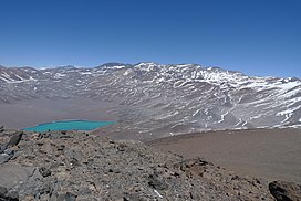
Wheelwright caldera is a caldera in Chile. It is variously described as being between 11 kilometres (6.8 mi) and 22 kilometres (14 mi) wide and lies in the Central Volcanic Zone of the Andes. A lake lies within the caldera, which is among the largest of the Central Andes. The caldera lies in the region of Ojos del Salado, the world's tallest volcano.

Vallecitos is a mountain subrange/area in Argentina. It has a height of 6,120 metres (20,079 ft). It is located at Antofagasta de la Sierra, Catamarca Province, at the Puna de Atacama.
Tocorpuri is a volcano in Chile, close to the border with Bolivia. Its peak height is most recently given as 5,808 metres (19,055 ft) and it features a 1.3 kilometres (0.81 mi) wide summit crater. The volcano consists mainly of lava flows and pyroclastic deposits and is subdivided into two separate edifices. Just west of Tocorpuri, the La Torta lava dome is a 200 metres (660 ft) high flat-topped structure. The volcanoes are formed by andesitic, dacitic and rhyolitic rocks.

Nevado Tres Cruces is a massif of volcanic origin in the Andes Mountains on the border of Argentina and Chile. It has two main summits, Tres Cruces Sur at 6,748 metres (22,139 ft) and Tres Cruces Centro at 6,629 m (21,749 ft) and a third minor summit, Tres Cruces Norte 6,030 m (19,780 ft). Tres Cruces Sur is the sixth highest mountain in the Andes.
Laguna Blanca is a peak in Argentina with an elevation of 6,012 metres (19,724 ft) metres. Laguna Blanca is the highest peak of Sierra de Laguna Blanca, a range within Puna de Atacama, a high plateau of the Andes. It is within the protected area "Natural Provincial Reserve and Biosphere of Laguna Blanca". Cerro Laguna Blanca is located within the territory of the Argentinean province of Catamarca. Its slopes are within the administrative boundaries of two Argentine cities: Antofagasta de la Sierra and Villa Vil.