The Huastec or Téenek are an indigenous people of Mexico, living in the La Huasteca region including the states of Hidalgo, Veracruz, San Luis Potosí and Tamaulipas concentrated along the route of the Pánuco River and along the coast of the Gulf of Mexico.

The Mayan languages form a language family spoken in Mesoamerica, both in the south of Mexico and northern Central America. Mayan languages are spoken by at least six million Maya people, primarily in Guatemala, Mexico, Belize, El Salvador and Honduras. In 1996, Guatemala formally recognized 21 Mayan languages by name, and Mexico recognizes eight within its territory.

Huehuetenango is one of the 22 departments of Guatemala. It is located in the western highlands and shares the borders with the Mexican state of Chiapas in the north and west; with El Quiché in the east, and Totonicapán, Quetzaltenango and San Marcos in the south. The capital is the city of Huehuetenango.

Totonicapán is one of the 22 departments of Guatemala. The capital is the city of Totonicapán.

Páramo may refer to a variety of alpine tundra ecosystems located in the Andes Mountain Range, South America. Some ecologists describe the páramo broadly as "all high, tropical, montane vegetation above the continuous timberline". A narrower term classifies the páramo according to its regional placement in the northern Andes of South America and adjacent southern Central America. The páramo is the ecosystem of the regions above the continuous forest line, yet below the permanent snowline. It is a "Neotropical high mountain biome with a vegetation composed mainly of giant rosette plants, shrubs and grasses". According to scientists, páramos may be "evolutionary hot spots", meaning that it's among the fastest evolving regions on Earth.

Santa María Nebaj is a town and municipality in the Guatemalan department of El Quiché. Santa María Nebaj is part of the Ixil Community, along with San Juan Cotzal and San Gaspar Chajul. Native residents speak the Mayan Ixil language.

Sacapulas is a town and municipality in the Guatemalan department of El Quiché.

Chiantla is a town and municipality in the Guatemalan department of Huehuetenango. The municipality is situated at 2,000 metres above sea level and covers an area of 521 km2. The annual festival is on January 28.

San Pedro Soloma is a town and municipality of Huehuetenango, a department of Guatemala. It is located in the Sierra de los Cuchumatanes at 2,300 m above sea level. The municipality covers a total area of 264 km2 with elevations ranging from 1,900 m to 3,500 m. Its population of 49,030 is spread over the town of Soloma, 19 villages and 50 smaller rural communities (caserios).

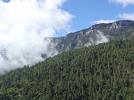
San Mateo Ixtatán is a municipality in the Guatemalan department of Huehuetenango. It is situated at 2,540 metres (8,330 ft) above sea level in the Cuchumatanes mountain range and covers 560 km² of terrain. It has a cold climate and is located in a cloud forest. The temperature fluctuates between 0.5 and 20 °C. The coldest months are from November to January and the warmest months are April and May. The town has a population of 15,090 and is the municipal center for an additional 28,000 people living in the surrounding mountain villages. It has a weekly market on Thursday and Sunday. The annual town festival takes place from September 19 to September 21, honoring their patron Saint Matthew. The residents of San Mateo belong to the Chuj Maya ethnic group and speak the Mayan Chuj language, not to be confused with Chuj baths, or wood-fired steam rooms, that are common throughout the central and western highlands.

San Juan Ixcoy is a municipality in the Guatemalan department of Huehuetenango. The municipality covers an area of 224 km2 (86 sq mi) and is formed by the town of San Juan Ixcoy, 11 villages and 33 caserios. Its population of 19,367 is predominantly of Maya Q'anjob'al descent.

Todos Santos Cuchumatán is a municipality in the Guatemalan department of Huehuetenango. It is situated in the Sierra de los Cuchumatanes at an elevation of 2,500 m. The municipality covers an area of approximately 269 km2 and is formed by the town of Todos Santos Cuchumatán, 6 villages, and 69 smaller rural communities, called caserios, parajes, and cantones. The village of San Martin Cuchumatán is the second largest urbanized centre in the municipality of Todos Santos. San Martin is also the agricultural heart of the Cuchumateca valley which produces crops like potatoes, broccoli and large scale cultivation of coffee on the lower mountain slopes of the municipality.
Concepción Chiquirichapa is a municipality in the Guatemalan department of Quetzaltenango in the Western Highlands of Guatemala, 14 kilometers west of the departmental capital of Quetzaltenango, and 214 kilometers west of the capital Guatemala City. The municipality has a population of 17,342, 98% of whom identify as indigenous Maya-Mam and speak a dialect of Southern Mam.

The Jakaltek people are a Maya people who lives alongside the border of the State of Chiapas in southern Mexico and the Department of Huehuetenango in northwestern Guatemala. Since pre-Columbian times they have lived alongside the modern Mexico-Guatemala border near the foothills of the Cuchumatán Mountains, mainly centered on the municipality of Jacaltenango.
The Chuj or Chuh are a Maya people, whose homeland is in Guatemala and Mexico. Population estimates vary between 30,000 and over 60,000. Their indigenous language is also called Chuj and belongs to the Q'anjobalan branch of Mayan languages. Most Chuj live in the Guatemalan department of Huehuetenango, in the municipalities of San Mateo Ixtatán and San Sebastián Coatán, with small numbers also residing in the neighboring border areas of the Mexican state of Chiapas. Los Angeles is believed to have a relatively large population of undocumented Chuj immigrants.
The Awakatek (Awakateko) are a indigenous Maya people located in the municiapality of Champotón, Campeche, México and in the municiaplity of Aguacatán in the department of Huehuetenango, Guatemala, place where they have their original settlement.

The Lakandon Chʼol were a former Chʼol-speaking Maya people inhabiting the Lacandon Jungle in what is now Chiapas in Mexico and the bordering regions of northwestern Guatemala, along the tributaries of the upper Usumacinta River and the foothills of the Sierra de los Cuchumatanes.

Wajxaklajun is a ruin of the ancient Maya civilization situated adjacent to the modern town of San Mateo Ixtatán, in the Huehuetenango Department of Guatemala. Wajxaklajun is considered to be the most important archaeological site in the San Mateo Ixtatán area. The site has been dated to the Classic period. The Chuj Maya consider the city to have been built by their ancestors. The site has similarities with other nearby highland Maya ruins; it is unusual for the presence of a number of stelae, a feature more associated with lowland sites during the Classic period, probably indicating some level of exchange with lowland cities.

Kʼatepan, also known as Yolchonabʼ, is an archaeological site of the ancient Maya civilization located 1 kilometre (0.62 mi) to the east of the modern town of San Mateo Ixtatán, in the Huehuetenango Department of Guatemala. The name Kʼatepan translates as "old church", while the alternate name of Yolchonabʼ means "in the village". The site consists of a small temple plaza in front of two large terraces set against a mountainside, accessed by broad stairways. The site was first described by Guatemalan historian Adrián Recinos in 1913. Recinos considered Kʼatepan to be the most important ceremonial site in the northern Sierra de los Cuchumatanes mountains. A preliminary map of Kʼatepan was produced in 2007.
A chuj is a traditional Mayan bathhouse. It is a sweat bath or steam bath. Traditional chuj had stone walls and live sod roofs. Today, some chuj are made out of adobe bricks or cinder blocks instead.