Sioux Valley, Minnesota

Last updated
Sioux Valley
USA Minnesota location map.svg
Red pog.svg
Sioux Valley
Usa edcp location map.svg
Red pog.svg
Sioux Valley
Coordinates: 43°32′38″N95°18′17″W / 43.54389°N 95.30472°W / 43.54389; -95.30472 Coordinates: 43°32′38″N95°18′17″W / 43.54389°N 95.30472°W / 43.54389; -95.30472
Country United States
State Minnesota
County Jackson
Township Sioux Valley
Elevation
[1]
1,473 ft (449 m)
Time zone UTC-6 (Central (CST))
  Summer (DST) UTC-5 (CDT)
GNIS feature ID652087 [1]

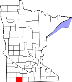
Sioux Valley is an unincorporated community in Sioux Valley Township, Jackson County, Minnesota, United States. [2]

Related Research Articles

Minnehaha County, South Dakota County in South Dakota, United States

Minnehaha County is a county on the eastern border of the state of South Dakota. As of the 2020 census, the population was 197,214, making it the state's most populous county. It contains over 20% of the state's population. Its county seat is Sioux Falls, South Dakota's largest city. The county was created in 1862 and organized in 1868. Its name was derived from the Sioux word Mnihaha, meaning "rapid water," or "waterfall".

Scott County, Minnesota County in Minnesota, United States

Scott County is a county in the U.S. state of Minnesota. As of the 2020 census, the population was 150,928. Its county seat is Shakopee. Shakopee is also the largest city in Scott County, the twenty-third-largest city in Minnesota, and the sixteenth-largest Twin Cities suburb. The county was organized in 1853 and named in honor of General Winfield Scott. Scott County is part of the Minneapolis-St. Paul-Bloomington, MN-WI Metropolitan Statistical Area. It is a member of the Metropolitan Council, and shares many of the council's concerns about responsible growth management, advocating for progressive development concepts such as clustering, open-space design, and the preservation of open space and rural/agricultural land.

Nobles County, Minnesota County in Minnesota, United States

Nobles County is a county in the U.S. state of Minnesota. As of the 2020 census, the population was 22,290. Its county seat is Worthington. Nobles County comprises the Worthington, MN Micropolitan Statistical Area.

Jackson County, Minnesota County in Minnesota, United States

Jackson County is a county in the U.S. state of Minnesota. As of the 2020 census, the population was 9,989. Its county seat is Jackson.

Dakota County, Minnesota County in Minnesota, United States

Dakota County is the third-most populous county in the U.S. state of Minnesota, located in the east central portion of the state. As of the 2020 census, the population was 439,882. The population of Dakota County was estimated to be 442,038 in 2021. The county seat is Hastings. Dakota County is named for the Dakota Sioux tribal bands who inhabited the area. The name is recorded as "Dahkotah" in the United States Census records until 1851. Dakota County is included in the Minneapolis–St. Paul–Bloomington, MN–WI Metropolitan Statistical Area, the sixteenth largest metropolitan area in the United States with about 3.64 million residents. The largest city in Dakota County is the city of Lakeville, the eleventh-largest city in Minnesota and sixth-largest Twin Cities suburb. The county is bordered by the Minnesota and Mississippi Rivers on the north, and the state of Wisconsin on the east.

Scouting in Minnesota Aspect of history

Scouting in Minnesota has a long history, from the 1910s to the present day, serving thousands of youth in programs that suit the environment in which they live.

Scouting in South Dakota

Scouting in South Dakota has a long history, from the 1910s to the present, and serves thousands of youth in programs that suit the environment in which they live.

Sioux Valley Township is a township in Jackson County, Minnesota, United States. The population was 192 as of the 2010 census.

Wahpeton, North Dakota City in North Dakota, United States

Wahpeton is a city in Richland County, in southeast North Dakota along the Bois de Sioux River at its confluence with the Otter Tail River, which forms the Red River of the North. Wahpeton is the county seat of Richland County. The population was 8,007 at the 2020 census.

Brandon, South Dakota City in South Dakota, United States

Brandon is a city in Minnehaha County, South Dakota, United States. Brandon is located five miles east of Sioux Falls. The population was 11,048 as of the 2020 census.

Rush Lake may refer to:

Siouxland Region of the United States

Siouxland is a vernacular region that encompasses the entire Big Sioux River drainage basin in the U.S. states of South Dakota, Minnesota, Nebraska and Iowa. The demonym for a resident of Siouxland is Siouxlander.

Lower Sioux Agency United States historic place

The Lower Sioux Agency, or Redwood Agency, was the federal administrative center for the Lower Sioux Indian Reservation in what became Redwood County, Minnesota, United States. It was the site of the Battle of Lower Sioux Agency on August 18, 1862, the first organized battle of the Dakota War of 1862.

Dissected Till Plains Physiographic section of the central United States

The Dissected Till Plains are physiographic sections of the Central Lowlands province, which in turn is part of the Interior Plains physiographic division of the United States, located in southern and western Iowa, northeastern Kansas, the southwestern corner of Minnesota, northern Missouri, eastern Nebraska, and southeastern South Dakota.

Chicago, St. Paul, Minneapolis and Omaha Railway

The Chicago, St. Paul, Minneapolis and Omaha Railway or Omaha Road was a railroad in the U.S. states of Nebraska, Iowa, Minnesota, Wisconsin and South Dakota. It was incorporated in 1880 as a consolidation of the Chicago, St. Paul and Minneapolis Railway and the North Wisconsin Railway. The Chicago and North Western Railway (C&NW) gained control in 1882. The C&NW leased the Omaha Road in 1957 and merged the company into itself in 1972. Portions of the C. St. P. M. and O. are part of the Union Pacific Railroad network. This includes main lines from Wyeville, Wisconsin, to St. Paul, Minnesota, and St. Paul to Sioux City, Iowa.

Rock River (Big Sioux River tributary) River in Minnesota, United States

The Rock River is a tributary of the Big Sioux River, about 144 miles (232 km) long, in southwestern Minnesota and northwestern Iowa in the United States. Via the Big Sioux and Missouri rivers, it is part of the watershed of the Mississippi River. The river's name comes from a prominent rocky outcrop about 175 feet high of reddish-gray Sioux Quartzite, about 3 miles (5 km) north of Luverne. The outcrop of quartzite is contained in Minnesota's Blue Mounds State Park.

Dakota War of 1862 Armed conflict between the United States and four bands of the eastern Dakota

The Dakota War of 1862, also known as the Sioux Uprising, the Dakota Uprising, the Sioux Outbreak of 1862, the Dakota Conflict, the U.S.-Dakota War of 1862, or Little Crow's War, was an armed conflict between the United States and several bands of eastern Dakota also known as the Santee Sioux. It began on August 18, 1862, at the Lower Sioux Agency along the Minnesota River in southwest Minnesota.

Manley is an unincorporated community in Beaver Creek Township, Rock County, Minnesota, United States.

Shakopee, Minnesota City in Minnesota, United States

Shakopee is a city in and the county seat of Scott County, Minnesota, United States. It is located southwest of Minneapolis. Sited on the south bank bend of the Minnesota River, Shakopee and nearby suburbs comprise the southwest portion of Minneapolis-Saint Paul, the sixteenth-largest metropolitan area in the United States, with 3.6 million people. The population of Shakopee was 43,698 at the 2020 census.

Sioux Valley Township may refer to one of the following places in the United States:

References