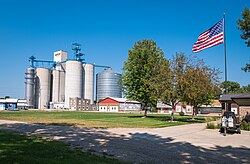
Heron Lake, Minnesota

Last updated

Heron Lake
Heron Lake, MN.jpg
Jackson County Minnesota Incorporated and Unincorporated areas Heron Lake Highlighted.svg
Location of Heron Lake, Minnesota
Coordinates: 43°47′53″N95°19′11″W / 43.79806°N 95.31972°W / 43.79806; -95.31972
Country United States
State Minnesota
County Jackson
Government
  TypeMayor Council
  MayorAndrew Rasche[ citation needed ]
Area
[1]
  Total1.24 sq mi (3.22 km2)
  Land1.24 sq mi (3.22 km2)
  Water0.00 sq mi (0.00 km2)
Elevation
[2]
1,421 ft (433 m)
Population
 (2020)
  Total602
  Density484.70/sq mi (187.13/km2)
Time zone UTC-6 (Central (CST))
  Summer (DST) UTC-5 (CDT)
ZIP code
56137
Area code 507
FIPS code 27-28700 [3]
GNIS feature ID2394364 [2]
Website www.heronlakecity.org

Heron Lake is a city in Jackson County, Minnesota, United States. The population was 698 at the 2010 census. [4]

Contents

History

Heron Lake was named in 1870 after a local lake where great blue herons were seen. [5]

Heron Lake was named after the Black-Crowned Night Heron.

Geography

According to the United States Census Bureau, the city has a total area of 1.28 square miles (3.32 km2), all land. [6]

Minnesota State Highway 60 serves as a main route in the community.

Demographics

Historical population
CensusPop.Note
1880 163
1890 496204.3%
1900 92887.1%
1910 803−13.5%
1920 92214.8%
1930 786−14.8%
1940 8528.4%
1950 837−1.8%
1960 8521.8%
1970 777−8.8%
1980 7830.8%
1990 730−6.8%
2000 7685.2%
2010 698−9.1%
2020 602−13.8%
U.S. Decennial Census [7]

2010 census

As of the census [8] of 2010, there were 698 people, 306 households, and 164 families residing in the city. The population density was 545.3 inhabitants per square mile (210.5/km2). There were 343 housing units at an average density of 268.0 per square mile (103.5/km2). The racial makeup of the city was 92.1% White, 1.9% African American, 1.3% Native American, 0.3% Asian, 4.2% from other races, and 0.3% from two or more races. Hispanic or Latino of any race were 12.0% of the population.

There were 306 households, of which 28.8% had children under the age of 18 living with them, 44.8% were married couples living together, 6.5% had a female householder with no husband present, 2.3% had a male householder with no wife present, and 46.4% were non-families. 39.5% of all households were made up of individuals, and 23.2% had someone living alone who was 65 years of age or older. The average household size was 2.28 and the average family size was 3.12.

The median age in the city was 41.5 years. 23.8% of residents were under the age of 18; 9.6% were between the ages of 18 and 24; 21.9% were from 25 to 44; 26% were from 45 to 64; and 18.8% were 65 years of age or older. The gender makeup of the city was 50.4% male and 49.6% female.

2000 census

As of the census [3] of 2000, there were 768 people, 285 households, and 174 families residing in the city. The population density was 723.4 inhabitants per square mile (279.3/km2). There were 322 housing units at an average density of 303.3 per square mile (117.1/km2). The racial makeup of the city was 92.58% White, 0.52% Asian, 6.38% from other races, and 0.52% from two or more races. Hispanic or Latino of any race were 10.55% of the population.

There were 285 households, out of which 32.6% had children under the age of 18 living with them, 51.9% were married couples living together, 6.3% had a female householder with no husband present, and 38.9% were non-families. 34.4% of all households were made up of individuals, and 17.2% had someone living alone who was 65 years of age or older. The average household size was 2.52 and the average family size was 3.30.

In the city, the population was spread out, with 26.7% under the age of 18, 7.6% from 18 to 24, 25.4% from 25 to 44, 15.9% from 45 to 64, and 24.5% who were 65 years of age or older. The median age was 39 years. For every 100 females, there were 97.9 males. For every 100 females age 18 and over, there were 97.5 males.

The median income for a household in the city was $32,222, and the median income for a family was $40,625. Males had a median income of $28,958 versus $19,219 for females. The per capita income for the city was $15,657.

Notable people

Harvey Edwin Swennes (1899-1964), newspaper editor, publisher, and Minnesota state legislator, was born in Heron Lake. [9]

Garland Buckeye (1897-1975), hailed from the small town of Heron Lake. Mr. Buckeye played both baseball and football professionally between 1918 and 1928. [10]

Politics

Heron Lake is located in Minnesota's 1st congressional district, represented by Republican Jim Hagedorn. At the state level, Heron Lake is located in Senate District 22, represented by Republican Bill Weber (politician), and in House District 22B, represented by Republican Rod Hamilton.

Related Research Articles

<span class="mw-page-title-main">Circle Pines, Minnesota</span> City in Minnesota, United States

Circle Pines is a city in Anoka County, Minnesota, United States. The population was 5,025 at the 2020 census.

<span class="mw-page-title-main">East Bethel, Minnesota</span> City in Minnesota, United States

East Bethel is a city in Anoka County, Minnesota, United States. The population was 11,786 at the 2020 census.

<span class="mw-page-title-main">East Gull Lake, Minnesota</span> City in Minnesota, United States

East Gull Lake is a city in Cass County, Minnesota, United States. The population was 986 at the 2020 census. The nearest semi-urban area is that of Brainerd and Baxter. It is part of the Brainerd Micropolitan Statistical Area. East Gull Lake is in Central Minnesota's Brainerd Lakes Area and takes its name from the largest lake within its borders, Gull Lake.

<span class="mw-page-title-main">Lake Shore, Minnesota</span> City in Minnesota, United States

Lake Shore is a city in Cass County, Minnesota, United States. The population was 1,056 at the 2020 census. It is part of the Brainerd Micropolitan Statistical Area.

<span class="mw-page-title-main">Emily, Minnesota</span> City in Minnesota, United States

Emily is a city in Crow Wing County, Minnesota, United States. The population was 813 at the 2010 census. It is part of the Brainerd Micropolitan Statistical Area.

<span class="mw-page-title-main">Twin Lakes, Freeborn County, Minnesota</span> City in Minnesota, United States

Twin Lakes is a city in Freeborn County, Minnesota, United States, near Albert Lea. The population was 134 at the 2020 census.

<span class="mw-page-title-main">Independence, Minnesota</span> City in Minnesota, United States

Independence is a rural city in Hennepin County, Minnesota, United States. Most of the city is agricultural land with dense woods and numerous lakes. It is named after Lake Independence, a large lake on the community's eastern boundary.

Heron Lake Township is a township in Jackson County, Minnesota, United States. The population was 401 at the 2000 census.

<span class="mw-page-title-main">Lakefield, Minnesota</span> City in Minnesota, United States

Lakefield is a city in Jackson County, Minnesota, United States. The population was 1,694 at the 2010 census.

West Heron Lake Township is a township in Jackson County, Minnesota, United States. The population was 202 at the 2000 census.

<span class="mw-page-title-main">Lake Bronson, Minnesota</span> City in Minnesota, United States

Lake Bronson is a city in Kittson County, Minnesota, United States. The population was 178 at the 2020 census. Lake Bronson State Park is nearby.

<span class="mw-page-title-main">Vergas, Minnesota</span> City in Minnesota, United States

Vergas is a city in northern Otter Tail County, Minnesota, United States. The population was 348 at the 2020 census.

<span class="mw-page-title-main">Sturgeon Lake, Minnesota</span> City in Minnesota, United States

Sturgeon Lake is a city in Pine County, Minnesota, United States. The population was 439 at the 2010 census.

<span class="mw-page-title-main">Hoyt Lakes, Minnesota</span> City in Minnesota, United States

Hoyt Lakes is a city in Saint Louis County, Minnesota. The population was 2,017 at the time of the 2010 census.

<span class="mw-page-title-main">Maple Lake, Minnesota</span> City in Minnesota, United States

Maple Lake is a city in Wright County, Minnesota, United States. The population was 2,159 at the 2020 census. Minnesota State Highway 55 serves as a main route in the city.

<span class="mw-page-title-main">Wood Lake, Minnesota</span> City in Minnesota, United States

Wood Lake is a city in Yellow Medicine County, Minnesota, United States. The population was 439 at the 2010 census.

<span class="mw-page-title-main">Lake Benton, Minnesota</span> City in Minnesota, United States

Lake Benton is a city in Lincoln County, Minnesota, United States. The population was 683 at the 2010 census.

<span class="mw-page-title-main">Silver Lake, Minnesota</span> City in Minnesota, United States

Silver Lake is a city in McLeod County, Minnesota, United States. The population was 866 at the 2020 census.

<span class="mw-page-title-main">Minnesota Lake, Minnesota</span> City in Minnesota, United States

Minnesota Lake is a city in Blue Earth and Faribault counties in the State of Minnesota. The population was 661 at the 2020 census. The bulk of the city is in Faribault County; a small part extends into Blue Earth County.

<span class="mw-page-title-main">Buckeye Lake, Ohio</span> Village in Ohio, United States

Buckeye Lake is a village in Fairfield and Licking counties in the U.S. state of Ohio. The population was 2,520 at the 2020 census. It is named for Buckeye Lake, a large lake along which the village is built.

References

  1. "2020 U.S. Gazetteer Files". United States Census Bureau. Retrieved July 24, 2022.
  2. 1 2 U.S. Geological Survey Geographic Names Information System: Heron Lake, Minnesota
  3. 1 2 "U.S. Census website". United States Census Bureau . Retrieved January 31, 2008.
  4. "2010 Census Redistricting Data (Public Law 94-171) Summary File". American FactFinder. United States Census Bureau . Retrieved April 27, 2011.[ dead link ]
  5. Chicago and North Western Railway Company (1908). A History of the Origin of the Place Names Connected with the Chicago & North Western and Chicago, St. Paul, Minneapolis & Omaha Railways. p. 178.
  6. "US Gazetteer files 2010". United States Census Bureau. Archived from the original on January 25, 2012. Retrieved November 13, 2012.
  7. "Census of Population and Housing". Census.gov. Retrieved June 4, 2015.
  8. "U.S. Census website". United States Census Bureau . Retrieved November 13, 2012.
  9. Minnesota Legislators: Past & Present-Harvey Edwin Swennes
  10. "Garland Buckeye", Wikipedia, June 18, 2023, retrieved August 4, 2023