Sisquoc River

Last updated
Siquoc River
Arroyo De Siquico [1]
Stringer of Steelhead Trout Upper Sisquoc River 1916.jpg
Stringer of Steelhead Trout on Upper Sisquoc River in 1916
Santa maria river map.png
Map of the Santa Maria River watershed, including the Sisquoc River
Location
Country United States
State California
Region Santa Barbara County, San Luis Obispo County
Cities Sisquoc, Garey
Physical characteristics
Source 
  locationBig Pine Mountain, Los Padres National Forest
  coordinates 34°41′42″N119°38′17″W / 34.69500°N 119.63806°W / 34.69500; -119.63806 [2]
  elevation6,320 ft (1,930 m)
Mouth  
  location
Confluence with Cuyama River
  coordinates
34°54′11″N120°18′45″W / 34.90306°N 120.31250°W / 34.90306; -120.31250 [2]
  elevation
354 ft (108 m) [2]
Basin features
Tributaries 
  leftBig Pine Canyon, Rattlesnake Canyon (Santa Barbara), Fall Canyon, South Fork Sisquoc River, [3] Big Bend Canyon, Miller Canyon, Bald Mountain Canyon, Manzana Creek, [4] Lion Canyon, Wildhorse Canyon, Bee Rock Canyon, Round Corral Canyon, Foxen Canyon, Olivera Canyon, Long Canyon
  rightJudell Canyon, Logan Canyon, Cliff Canyon, Sweetwater Canyon, Foresters Leap Canyon, Mine Canyon, Abel Canyon, Oak Canyon, Wellman Canyon, Water Canyon, Burro Canyon, Horse Canyon, [5] Rattlesnake Canyon, Tunnel Canyon, Alkali Canyon, La Brea Canyon
TypeWild
DesignatedJune 19, 1992

The Sisquoc River is a westward flowing river in northeastern Santa Barbara County, California. It is a tributary of the Santa Maria River, which is formed when the Sisquoc River meets the Cuyama River at the Santa Barbara County and San Luis Obispo County border just north of Garey. The river is 57.4 miles (92.4 km) long [6] and originates on the north slopes of Big Pine Mountain, [7] at approximately 6,320 feet (1,930 m). [8] Big Pine Mountain is part of the San Rafael Mountains, which are part of the Transverse Ranges.

Contents

History

"Sisquoc" is a Chumash word meaning "quail". The river is shown on an 1846 diseño of the Rancho Cuyama grant as Arroyo de Siquico. [1]

Watershed

The Sierra Madre Mountains form the watershed's boundary to the north, while the San Rafael Mountains form the southern boundary. The first half of the river, in the Los Padres National Forest, specifically the San Rafael Wilderness, travels roughly northwest. Outside of the National Forest, the river flows roughly west to its confluence with the Cuyama River, about 20 miles upstream from the Pacific Ocean. The river is completely free flowing and does not have any diversions. Its sole dam is a 3-meter dam on Horse Canyon, one of its tributaries, but it is filled with sediment and causes little restriction to the river's overall flow. It is designated as a wild and scenic river in the National Wild and Scenic Rivers System.

The watershed has a Mediterranean climate and chaparral vegetation. Annual precipitation in the watershed varies from 13 to 38 inches, 95% of which falls between November and April. This means that the river is dry part of the year, as there are no reservoirs to store water. The lack of rain also causes the vegetation to get very dry and the fire hazard can be very high during the summer.

Ecology

Southern Steelhead trout (Oncorhynchus mykiss) are thought to represent about 1% of the historic population and most of the Santa Maria River run is thought to have continued up the Sisquoc River to spawn. Major dams on the Santa Ynez, Ventura, and Santa Clara Rivers prevent steelhead from accessing hundreds of miles of habitat and have drastically reduced the steelhead runs. The construction of Twitchell Dam on the Cuyama River in the late 1950s blocked at least 264 miles of stream and more than 60% of the Santa Maria River watershed and tributary habitat found upstream. This makes the Sisquoc River, which remains undammed, an important stream for surviving southern steelhead populations. [9]

Removal of dams on Sisquoc River tributaries expands the potential for restoration of steelhead. [10] One tributary, Horse Creek (Horse Canyon), was dammed in 1968 and the 4.5 foot high, 60 foot wide dam eventually created a scour pool, increasing the drop to over 8 feet and creating an impassable barrier to spawning steelhead. The dam had completely silted in and no longer served to restrain sediment flows so was dynamited in 2006, and its sediment naturally eroded by 2011. A beaver dam created a large pool at the confluence of Horse Creek and the Sisquoc River and abundant steelhead trout were noted in a snorkel survey by fish biologist Matt Stoecker, including three fish 9 to 14 inches in size. [11]

The discovery of a male adult California Golden beaver (Castor canadensis subauratus) specimen collected as "wild caught" in 1906 "along the Sespe River in Ventura County" is physical evidence that Golden beaver were historically extant in coastal streams in southern California. [12] The Sisquoc River used to receive steelhead running up from the Pacific Ocean via the Santa Maria River, but water removed by Twitchell Reservoir has interrupted the connection. [13]

Zaca Fire

The Zaca Fire burned a large portion of the Sisqoc River watershed in the summer of 2007.

See also

Related Research Articles

<span class="mw-page-title-main">Santa Clara River (California)</span> River in Ventura and Los Angeles counties, California

The Santa Clara River is an 83 mi (134 km) long river in Ventura and Los Angeles counties in Southern California. It drains parts of four ranges in the Transverse Ranges System north and northwest of Los Angeles, then flows west onto the Oxnard Plain and into the Santa Barbara Channel of the Pacific Ocean.

<span class="mw-page-title-main">Guadalupe River (California)</span> River in Santa Clara County, California, United States

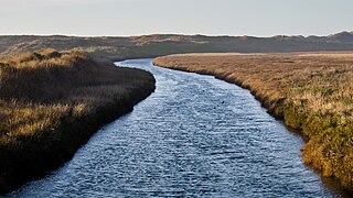
The Guadalupe River mainstem is an urban, northward flowing 14 miles (23 km) river in California whose much longer headwater creeks originate in the Santa Cruz Mountains. The river mainstem now begins on the Santa Clara Valley floor when Los Alamitos Creek exits Lake Almaden and joins Guadalupe Creek just downstream of Coleman Road in San Jose, California. From here it flows north through San Jose, where it receives Los Gatos Creek, a major tributary. The Guadalupe River serves as the eastern boundary of the City of Santa Clara and the western boundary of Alviso, and after coursing through San José, it empties into south San Francisco Bay at the Alviso Slough.

<span class="mw-page-title-main">Santa Margarita River</span> River in California, United States of America

The Santa Margarita River which with the addition of what is now Temecula Creek, was formerly known as the Temecula River, is a short intermittent river on the Pacific coast of southern California in the United States, approximately 30.9 miles (49.7 km) long. One of the last free-flowing rivers in southern California, it drains an arid region at the southern end of the Santa Ana Mountains, in the Peninsular Ranges between Los Angeles and San Diego.

<span class="mw-page-title-main">Coyote Creek (Santa Clara County)</span> Creek in California, United States

Coyote Creek is a river that flows through the Santa Clara Valley in Northern California. Its source is on Mount Sizer, in the mountains east of Morgan Hill. It eventually flows into Anderson Lake in Morgan Hill and then northwards through Coyote Valley to San Jose, where it empties into San Francisco Bay.

<span class="mw-page-title-main">Santa Ynez River</span> River in California, United States

The Santa Ynez River is one of the largest rivers on the Central Coast of California. It is 92 miles (148 km) long, flowing from east to west through the Santa Ynez Valley, reaching the Pacific Ocean at Surf, near Vandenberg Space Force Base and the city of Lompoc.

<span class="mw-page-title-main">Sespe Creek</span> Stream in California

Sespe Creek is a stream, some 61 miles (98 km) long, in Ventura County, southern California, in the Western United States. The creek starts at Potrero Seco in the eastern Sierra Madre Mountains, and is formed by more than thirty tributary streams of the Sierra Madre and Topatopa Mountains, before it empties into the Santa Clara River in Fillmore.

<span class="mw-page-title-main">Santa Maria River (California)</span> River in California, United States

Santa Maria River on the Central Coast of California, is formed at the confluence of the Sisquoc River and Cuyama River, just east of the city of Santa Maria, and flows 24.4 miles (39.3 km) to its delta at the Pacific Ocean.

<span class="mw-page-title-main">Carmel River (California)</span> River in Monterey County

The Carmel River is a 41 mi (66 km) river on the Central Coast of California in Monterey County that originates in the Ventana Wilderness of the Santa Lucia Mountains. The river flows northwest through Carmel Valley with its mouth at the Pacific Ocean south of Carmel-by-the-Sea, at Carmel Bay. The Carmel River is considered the northern boundary of Big Sur, the other boundaries being San Carpóforo Creek and the Pacific coastline.

<span class="mw-page-title-main">Cuyama River</span> River in California, United States

The Cuyama River is a 118-mile-long (190 km) river in southern San Luis Obispo County, northern Santa Barbara County, and northern Ventura County, in the U.S. state of California. It joins the Sisquoc River forming the Santa Maria River. The river's name comes from an Indian village named for the Chumash word kuyam, meaning "clam" or "freshwater mollusk".

<span class="mw-page-title-main">Salmon River (California)</span> River in California, United States

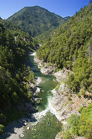
The Salmon River is a 19.6-mile-long (31.5 km) tributary to the Klamath River in western Siskiyou County, California.

<span class="mw-page-title-main">Los Gatos Creek (Santa Clara County)</span> River in California, United States

The Los Gatos Creek runs 24 miles (39 km) in California through Santa Clara Valley Water District's Guadalupe Watershed from the Santa Cruz Mountains northward through the Santa Clara Valley until its confluence with the Guadalupe River in downtown San Jose. The Guadalupe River then continues onward into San Francisco Bay.

<span class="mw-page-title-main">Pescadero Creek</span> River in California, United States

Pescadero Creek is a major stream in Santa Cruz and San Mateo counties in California, United States. At 26.6 miles (42.8 km), it is the longest stream in San Mateo County and flows all year from springs in the Santa Cruz Mountains. Its source is at 1,880 feet (570 m) above sea level on the western edge of Castle Rock State Park, with additional headwaters in Portola Redwoods State Park, and its course traverses Pescadero Creek County Park and San Mateo County Memorial Park before entering Pescadero Marsh Natural Preserve at Pescadero State Beach and thence to the Pacific Ocean 14.4 miles (23 km) south of Half Moon Bay.

<span class="mw-page-title-main">Matilija Creek</span> River in California, United States of America

Matilija Creek is a major stream in Ventura County in the U.S. state of California. It joins with North Fork Matilija Creek to form the Ventura River. Many tributaries feed the mostly free flowing, 17.3-mile (27.8 km) creek, which is largely contained in the Matilija Wilderness. Matilija was one of the Chumash rancherias under the jurisdiction of Mission San Buenaventura. The meaning of the Chumash name is unknown.

<span class="mw-page-title-main">Coyote Creek (Marin County)</span> River in California, United States

Coyote Creek is a stream in the Richardson Bay watershed, draining Tamalpais-Homestead Valley, California eastward into Richardson Bay, Marin County, California, United States. The stream originates on Coyote Ridge and flows 2.5 miles (4.0 km) to the bay at the south end of Bothin Marsh.

<span class="mw-page-title-main">Saratoga Creek</span> River in California, United States

Saratoga Creek is a north-northeast flowing creek in Santa Clara County, California.

<span class="mw-page-title-main">Salsipuedes Creek (Santa Ynez River tributary)</span> Stream in Santa Barbara County, California, US

Salsipuedes Creek is a 9.9 miles (15.9 km) long stream, flowing north to join the Santa Ynez River just southeast of Lompoc in Santa Barbara County, California. Salsipuedes Creek, along with its major tributary, El Jaro Creek, is the largest tributary to the lower Santa Ynez River, shortly before the river reaches the Pacific Ocean.

The Huasna River is a stream in the Central Coast region of California, and is a tributary of the Cuyama River. It is formed by the confluence of Trout Creek and Stony Creek, which originate along the crest of the Santa Lucia Range in the Los Padres National Forest. It flows south, past the community of Huasna and the Huasna Valley before reaching Twitchell Reservoir, which is created by a dam along the Cuyama River.

The Matilija Wilderness is a 29,207-acre (11,820 ha) wilderness area in Ventura and Santa Barbara Counties, Southern California. It is managed by the U.S. Forest Service, being situated within the Ojai Ranger District of the Los Padres National Forest. It is located adjacent to the Dick Smith Wilderness to the northwest and the Sespe Wilderness to the northeast, although it is much smaller than either one. The Matilija Wilderness was established in 1992 in part to protect California condor habitat.

<span class="mw-page-title-main">North Fork Pacheco Creek</span> River in California, United States

North Fork Pacheco Creek is a 19 miles (31 km) tributary stream of Pacheco Creek, in Santa Clara County, California. Originally it was considered the upper reach of Pacheco Creek. Its source is at an elevation of 2,360 feet (720 m) at 37°11′17″N121°25′42″W on a mountain side in Henry W. Coe State Park and is the headwaters of the Pajaro River watershed.

References

  1. 1 2 Erwin G. Gudde, William Bright (2004). California Place Names: The Origin and Etymology of Current Geographical Names. University of California Press. p. 364. ISBN   978-0-520-24217-3.
  2. 1 2 3 U.S. Geological Survey Geographic Names Information System: Sisquoc River
  3. "Sisquoc River". Geographic Names Information System . United States Geological Survey, United States Department of the Interior.
  4. "Manzana Creek". Geographic Names Information System . United States Geological Survey, United States Department of the Interior.
  5. "Horse Canyon". Geographic Names Information System . United States Geological Survey, United States Department of the Interior.
  6. U.S. Geological Survey. National Hydrography Dataset high-resolution flowline data. The National Map, accessed March 15, 2011
  7. U.S. Geological Survey Geographic Names Information System: Big Pine Mountain
  8. Calculated using Google Earth and source coordinates from U.S. Geological Survey Geographic Names Information System: Sisquoc River
  9. Matt Stoecker, Jim Stoecker (2003-01-23). Steelhead Migration Barrier Assessment and Recovery Opportunities for the Sisquoc River, California (Report). Coastal Conservancy.
  10. Steelhead/rainbow trout resources of Santa Barbara County (PDF) (Report). Oakland, California: Center for Ecosystem Management and Restoration (CEMAR). pp. 256–260. Retrieved 2012-03-15.
  11. Michael Love; Don Baldwin (2012-02-27). CDFG Horse Creek Post-Dam Removal Snorkel Survey Results (Report). State of California Department of Fish and Game.
  12. "MVZ Mammals 4918 Castor canadensis subauratus Sespe River". Berkeley, California: Museum of Vertebrate Zoology. Retrieved 2012-03-13.
  13. "Santa Maria River Instream Flow Study". Stillwater Sciences. Retrieved 2012-03-15.