Smithsonia, Alabama | |
|---|---|
 Smithsonia  Smithsonia | |
| Coordinates: 34°47′39″N87°52′45″W / 34.79417°N 87.87917°W | |
| Country | United States |
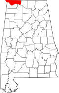
| State | Alabama |
| County | Lauderdale |
| Elevation | 512 ft (156 m) |
| Time zone | UTC-6 (Central (CST)) |
| • Summer (DST) | UTC-5 (CDT) |
| Area codes | 256 & 938 |
| GNIS feature ID | 157080 [1] |
Smithsonia, also known as Cave Springs, is an unincorporated community in Lauderdale County, in the U.S. state of Alabama.