St. Florian, Alabama

Last updated

St. Florian, Alabama
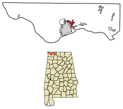
Lauderdale County Alabama Incorporated and Unincorporated areas St. Florian Highlighted 0167536.svg
Location of St. Florian in Lauderdale County, Alabama.
Coordinates: 34°52′22″N87°37′30″W / 34.87278°N 87.62500°W / 34.87278; -87.62500
Country United States
State Alabama
County Lauderdale
Area
[1]
  Total4.39 sq mi (11.36 km2)
  Land4.37 sq mi (11.31 km2)
  Water0.02 sq mi (0.05 km2)
Elevation
[2]
627 ft (191 m)
Population
 (2020)
  Total584
  Density133.76/sq mi (51.64/km2)
Time zone UTC-6 (Central (CST))
  Summer (DST) UTC-5 (CDT)
FIPS code 01-67536
GNIS feature ID0153248 [2]
Website http://www.stflorianalabama.com/

St. Florian is a town in Lauderdale County, Alabama, United States. It is part of the Florence - Muscle Shoals Metropolitan Statistical Area known as "The Shoals". As of the 2010 census, the population of the town is 413, up from 335 in 2000.

Contents

History

The area was first called Wilson Stand, for John and Matthew Wilson, the original owners of the town site. [3] The present community was founded in the 1870s by a colony of Germans who named the town after Saint Florian. [4] A post office was established at St. Florian in 1879, and remained in operation until it was discontinued in 1904. [5] The town incorporated at some point in the 1970s, as cited by the 1980 U.S. Census. [6]

Geography

St. Florian is located at 34°52′22″N87°37′30″W / 34.87278°N 87.62500°W / 34.87278; -87.62500 (34.872753, -87.625117). [7]

According to the U.S. Census Bureau, the town has a total area of 3.0 square miles (7.8 km2), all land.

Demographics

Historical population
CensusPop.Note
1880 135
1970 168
1980 30581.5%
1990 38827.2%
2000 335−13.7%
2010 41323.3%
2020 58441.4%
U.S. Decennial Census [8]
2013 Estimate [9]

As of the census [10] of 2000, there were 335 people, 129 households, and 103 families residing in the town. The population density was 112.3 inhabitants per square mile (43.4/km2). There were 140 housing units at an average density of 46.9 per square mile (18.1/km2). The racial makeup of the town was 98.81% White, 0.60% Black or African American and 0.60% Asian.

There were 129 households, out of which 34.1% had children under the age of 18 living with them, 72.9% were married couples living together, 2.3% had a female householder with no husband present, and 19.4% were non-families. 17.1% of all households were made up of individuals, and 8.5% had someone living alone who was 65 years of age or older. The average household size was 2.60 and the average family size was 2.89.

In the town, the population was spread out, with 22.1% under the age of 18, 6.9% from 18 to 24, 31.0% from 25 to 44, 28.4% from 45 to 64, and 11.6% who were 65 years of age or older. The median age was 40 years. For every 100 females, there were 94.8 males. For every 100 females age 18 and over, there were 102.3 males.

The median income for a household in the town was $46,250, and the median income for a family was $48,125. Males had a median income of $36,364 versus $21,250 for females. The per capita income for the town was $17,522. About 9.2% of families and 9.8% of the population were below the poverty line, including 16.5% of those under age 18 and 7.5% of those age 65 or over.

Related Research Articles

<span class="mw-page-title-main">Colbert County, Alabama</span> County in Alabama, United States

Colbert County is a county located in the northwestern part of the U.S. state of Alabama. As of the 2020 census the county's population was 57,227. The county seat is Tuscumbia. The largest city is Muscle Shoals.

<span class="mw-page-title-main">Lauderdale County, Alabama</span> County in Alabama, United States

Lauderdale County is a county located in the northwestern corner of the U.S. state of Alabama. At the 2020 census the population was 93,564. Its county seat is Florence. Its name is in honor of Colonel James Lauderdale, of Tennessee. Lauderdale is part of the Florence-Muscle Shoals, AL Metropolitan Statistical Area, also known as "The Shoals".

<span class="mw-page-title-main">Leighton, Alabama</span> Town in Alabama, United States

Leighton is a town in Colbert County, Alabama, United States. It is part of the Florence - Muscle Shoals Metropolitan Statistical Area known as "The Shoals". At the 2020 census, the population was 665. Leighton has been hit by several tornadoes in the 2000s, including a damaging EF2 on May 8, 2008, that was caught on tape flipping over many cars and damaging buildings.

<span class="mw-page-title-main">Littleville, Alabama</span> Town in Alabama, United States

Littleville is a town located on the southern border of Colbert County, Alabama, United States, and extends into Franklin County. It is part of the Florence - Muscle Shoals Metropolitan Statistical Area known as "The Shoals". As of the 2010 census, the population of the town was 1,011.

<span class="mw-page-title-main">Arab, Alabama</span> City in Alabama, United States

Arab is a city in Marshall County in the northern part of the U.S. state of Alabama, located 10 miles (16 km) from Guntersville Lake and Guntersville Dam, and is included in the Huntsville-Decatur Combined Statistical Area. The population was 8,461 at the 2020 census.

<span class="mw-page-title-main">Forkland, Alabama</span> Town in Alabama, United States

Forkland is a town in Greene County, Alabama, United States. At the 2020 census, the population was 445. It was incorporated around 1974.

<span class="mw-page-title-main">Anderson, Alabama</span> Town in Alabama, United States

Anderson is a town in Lauderdale County, Alabama, United States. It is part of the Florence - Muscle Shoals Metropolitan Statistical Area known as "The Shoals". As of the 2010 U.S. Census, the town had a population of 282, down from 354 in 2000.

<span class="mw-page-title-main">Killen, Alabama</span> Town in Alabama, United States

Killen is a town in Lauderdale County, Alabama, United States. It's part of the Florence - Muscle Shoals Metropolitan Statistical Area known as "The Shoals". It was incorporated in 1957. As of the 2020 census, the population of the town is 1,034, down from its record high of 1,119 in 2000.

<span class="mw-page-title-main">Lexington, Alabama</span> Town in Alabama, United States

Lexington is a town in Lauderdale County, Alabama, United States. It is part of the Florence–Muscle Shoals Metropolitan Statistical Area known as "The Shoals". It incorporated in 1959. As of the 2010 census, the population of the town is 735, down from 840 in 2000. The current mayor of Lexington is Sandra Killen-Burroughs.

<span class="mw-page-title-main">Rogersville, Alabama</span> Town in Alabama, United States

Rogersville is a town in Lauderdale County, Alabama, United States. As of the 2018 census, the population of the town is 1,231, up from 1,199 in 2000.

<span class="mw-page-title-main">Underwood-Petersville, Alabama</span> Census-designated place in Alabama, United States

Underwood-Petersville is a census-designated place (CDP) in Lauderdale County, Alabama United States. It is part of the Florence - Muscle Shoals Metropolitan Statistical Area known as "The Shoals". As of the 2010 census, the population of the CDP is 3,247.

<span class="mw-page-title-main">Waterloo, Alabama</span> Town in Alabama, United States

Waterloo is a town in Lauderdale County, Alabama, United States. It is part of the Florence–Muscle Shoals metropolitan area, known as "The Shoals". As of the 2010 census, the population of the town was 203, down from 208 in 2000. The town and surrounding area is served by Waterloo High School and by the Waterloo Volunteer Fire Department.

<span class="mw-page-title-main">Courtland, Alabama</span> Town in Alabama, United States

Courtland is a town in Lawrence County, Alabama, United States, and is included in the Decatur Metropolitan Area, as well as the Huntsville-Decatur Combined Statistical Area. The population was 609 at the 2010 census, down from 769 in 2000.

<span class="mw-page-title-main">Bardwell, Kentucky</span> City in Kentucky, United States

Bardwell is a home rule-class city in and the county seat of Carlisle County, Kentucky, United States. The city was formally incorporated by the state assembly in 1878. The population was 714 at the 2020 census, down from 723 in 2010. Bardwell is included in the Paducah, KY-IL Metropolitan Statistical Area.

<span class="mw-page-title-main">Armagh Township, Pennsylvania</span> Township in Pennsylvania, United States

Armagh Township is a township in Mifflin County in the U.S. state of Pennsylvania. The population was 4,019 at the 2020 census.

<span class="mw-page-title-main">Nicholson, Pennsylvania</span> Borough in Pennsylvania, United States

Nicholson is a borough in Wyoming County, Pennsylvania. The population was 698 at the 2020 census.

<span class="mw-page-title-main">Falcon Mesa, Texas</span> CDP in Texas, United States

Falcon Mesa is a census-designated place (CDP) in Zapata County, Texas, United States. The population was 405 at the 2010 census.

<span class="mw-page-title-main">East Port Orchard, Washington</span> CDP in Washington, United States

East Port Orchard is a census-designated place (CDP) in Kitsap County, Washington, United States. The population was 5,919 at the 2010 census.

The town of Spring Valley is located in Rock County, in the U.S. state of Wisconsin. The population was 728 at the 2020 census. The only incorporated municipality in the town is the village of Orfordville.

<span class="mw-page-title-main">Slater, Wyoming</span> CDP in Wyoming, United States

Slater is a census-designated place (CDP) in Platte County, Wyoming, United States. The population was 80 at the 2010 census.

References

  1. "2020 U.S. Gazetteer Files". United States Census Bureau. Retrieved October 29, 2021.
  2. 1 2 U.S. Geological Survey Geographic Names Information System: St. Florian, Alabama
  3. "What's the origin of your town's name?". Times Daily. June 3, 2006. pp. 4A. Retrieved October 18, 2015.
  4. Darby, A. J. (March 1, 1962). "The Historical Highways and Byways of Lauderdale County". TimesDaily . pp. Page 6, Section 3. Retrieved April 23, 2015.
  5. "Lauderdale County". Jim Forte Postal History. Retrieved April 23, 2015.
  6. Bureau of the Census (April 1982). "1980 Census Characteristics of the Population - Number of Inhabitants - Alabama" (PDF).
  7. "US Gazetteer files: 2010, 2000, and 1990". United States Census Bureau. February 12, 2011. Retrieved April 23, 2011.
  8. "U.S. Decennial Census". Census.gov. Retrieved June 6, 2013.
  9. "Annual Estimates of the Resident Population: April 1, 2010 to July 1, 2013" . Retrieved June 3, 2014.
  10. "U.S. Census website". United States Census Bureau . Retrieved January 31, 2008.

34°52′22″N87°37′30″W / 34.872753°N 87.625117°W / 34.872753; -87.625117