Smithton, Kansas

Last updated
Smithton, Kansas
USA Kansas location map.svg
Red pog.svg
Smithton
Usa edcp location map.svg
Red pog.svg
Smithton
Coordinates: 39°57′34″N99°51′05″W / 39.95944°N 99.85139°W / 39.95944; -99.85139
Country United States
State Kansas
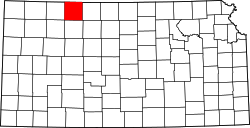
County Norton
Elevation
2,428 ft (740 m)
Population
  Total0
Time zone UTC-6 (CST)
  Summer (DST) UTC-5 (CDT)
GNIS ID 482416 [1]

Smithton is a ghost town in Norton County, Kansas, United States.

Contents

History

Smithton was issued a post office in 1884. The post office was discontinued in 1886. [2]

Related Research Articles

<span class="mw-page-title-main">Pettis County, Missouri</span> County in Missouri, United States

Pettis County is a county located in west central U.S. state of Missouri. As of the 2020 census, the population was 42,980. Its county seat is Sedalia. The county was organized on January 24, 1833, and named after former U.S. Representative Spencer Darwin Pettis.

<span class="mw-page-title-main">Norton County, Kansas</span> County in Kansas, United States

Norton County is a county located in the U.S. state of Kansas. Its county seat and largest city is Norton. As of the 2020 census, the county population was 5,459. The county was established in 1867 and named for Orloff Norton, captain of Company L, 15th Kansas Militia Infantry Regiment.

<span class="mw-page-title-main">Smithton, Pennsylvania</span> Borough in Pennsylvania, United States

Smithton is a borough in Westmoreland County, Pennsylvania, United States. The population was 399 at the 2010 census. As of 2018, the population was listed at 378. Smithton has its own post office, with zip code 15479, and is serviced by Yough School District.

Smithton is a town on the far north-west coast of Tasmania, Australia. It lies on the Bass Highway, 85 km north-west of Burnie. At the 2021 census, Smithton had a population of 3,934. Smithton is the administrative centre of the Circular Head Council.

Oronoque is an unincorporated community in Norton County, Kansas, United States.

<span class="mw-page-title-main">Densmore, Kansas</span> Unincorporated community in Norton County, Kansas

Densmore is an unincorporated community in Norton County, Kansas, United States, approximately two miles east of the city of Edmond near K-9 highway.

Calvert is an unincorporated community in Norton County, Kansas, United States.
Dellvale is an unincorporated community in Norton County, Kansas, United States.

Reager is an unincorporated community in Norton County, Kansas, United States.

Bower is a ghost town in Norton County, Kansas, United States.

Brett is a ghost town in Norton County, Kansas, United States.

Cactus is a ghost town in Norton County, Kansas, United States.

Fairhaven is a ghost town in Norton County, Kansas, United States.

Hanback is a ghost town in Norton County, Kansas, United States.

Hedgewood is a ghost town in Norton County, Kansas, United States.

Rayville is a ghost town in Norton County, Kansas, United States.

Wakeman is a ghost town in Norton County, Kansas, United States.

Devizes is a ghost town in Norton County, Kansas, United States.

<span class="mw-page-title-main">New Almelo, Kansas</span> Unincorporated community in Norton County, Kansas

New Almelo is an unincorporated community in Norton County, Kansas, United States.

Rockwell is a ghost town in Norton County, Kansas, United States.

References

  1. "US Board on Geographic Names". United States Geological Survey. 1984-07-01. Retrieved 2017-12-30.
  2. "Kansas Post Offices, 1828-1961". Kansas Historical Society. Retrieved 2018-01-02.

Further reading