Sohagpur (Shahdol)

Last updated
Sohagpur
City
Sohagpur
Madhya Pradesh location map.svg
Red pog.svg
Sohagpur
Location in Madhya Pradesh, India
India location map 3.png
Red pog.svg
Sohagpur
Sohagpur (India)
Coordinates: 23°18′N81°18′E / 23.3°N 81.3°E / 23.3; 81.3
CountryFlag of India.svg  India
State Madhya Pradesh
Government
  Type Bharatiya Janata Party
Elevation
508 m (1,667 ft)
Languages
  Official Bagheli
Time zone UTC+5:30 (IST)
PIN
484001
Website https://shahdol.nic.in/

Sohagpur is a Town and Tehsil in Shahdol District of Madhya Pradesh. It is one of 4 Tehsils of Shahdol district. There are 318 villages [1] in Sohagpur Tehsil. Rewa State Gazetteer refers to a tradition which connects Sohagpur with King Virata of the epic Mahabharata. [2]

Contents

Demographics

According to census 2011, [3] [4] information the sub-district code of Sohagpur Block (CD) is 03691. Total area of Sohagpur tehsil is 1,976 km² including 1,892.23 km² rural area and 83.85 km² urban area. Sohagpur tehsil [5] has a population of 4,86,930 peoples, out of which urban population is 1,76,169 while rural population is 3,10,761. Sohagpur tehsil has a population density of 246.4 inhabitants per square kilometre. There are about 1,11,421 houses in the sub-district, including 36,678 urban houses and 74,743 rural houses.

When it comes to literacy, 60.80% population of sohagpur tehsil is literate, out of which 67.83% males and 53.53% females are literate. There are about 318 villages in sohagpur tehsil.

Geography

Sohagpur is located at 23°19′02″N81°21′06″E / 23.3173°N 81.3518°E / 23.3173; 81.3518 . [6] It has an average elevation of 508 metres (1669 feet). Son is the local river.

Tourism

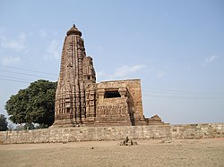
Banganga Mela was started by the then Rewa Maharaja Gulab Singh in 1895. Since then, the traditions of the fair are continuing in Banganga. The purpose of the fair is to make an indelible impression in the courtyard of the Virat Temple, built in a thousand years before, it signifies donation and virtue.The reconciliation and enthusiasm of people in the fair remained a witness to the nature of the tribals who love the old customs. When the fair was inaugurated, it was kept for three days. Which is now filling up for 5 days. [7]

Virateshwar Temple. ASI number N-MP-255 Virath Temple N-MP-255 Shahdol MP Kamlashanker Vishvakarma.jpg
Virateshwar Temple. ASI number N-MP-255

Virateshwar temple is a Shiv mandir that has an old statue of Lord Shiva. [8] [9] [10]

Transport

Nearest Airport is Jabalpur is 143 KM away. [11]

Shahdol Railway Station is well connected with major cities of the country.

Shahdol is well connected by road with major cities of the State as well as other nearby state. Regular Bus Services From Shahdol to Indore via Katni, Sagar ,Bhopal is available.

Related Research Articles

<span class="mw-page-title-main">Chhatarpur district</span> District in Madhya Pradesh, India

Chhatarpur District is a district of Madhya Pradesh state of central India. The town of Chhatarpur is the district headquarters.

<span class="mw-page-title-main">Rewa district</span> City and district of Madhya Pradesh in India

Rewa district is a district of the Madhya Pradesh state in central India. The city of Rewa is the district headquarter. Rewa is sometimes called – 'Land of White Tigers' as the first White Tiger was discovered here in 1951 by Maharaja of the province, Martand Singh in the nearby jungle of Govindgarh. Rewa was the capital city of once a state – Vindhya Pradesh.

<span class="mw-page-title-main">Shahdol district</span> District of Madhya Pradesh in India

Shahdol District is a district of Madhya Pradesh state in east central India. It old name was Matsya raj or Virat kingdom in the name of great king Maharaja Virata. With a total area of 6,205 km2 (2,396 sq mi) and a population of 10,66,063. Shahdol is an important district of Madhya Pradesh. The town of Shahdol is the district headquarters. The district formerly comprised Shahdol division.

<span class="mw-page-title-main">Umaria district</span> District of Madhya Pradesh in India

Umaria district is a district of Madhya Pradesh. The town of Umaria is the district headquarters. The district is part of Shahdol Division.

<span class="mw-page-title-main">Chhindwara district</span> District of Madhya Pradesh, India

Chhindwara district is one of the major districts of Madhya Pradesh state of India, and Chhindwara town is the district headquarters. Chhindwara was the largest district in Madhya Pradesh with an area of 11,815 square km before the bifurcation of Pandhurna district. The district is part of Jabalpur division.

Satna is a city in the Indian state of Madhya Pradesh. It serves as the headquarters of Satna district. It is 7th largest city and 8th most populous city of the state. The city is 500 km east of the state capital Bhopal. The city is distributed over a land area of 111.9 square kilometres.

<span class="mw-page-title-main">Anuppur district</span> District of Madhya Pradesh in India

Anuppur District (अनूपपुर) is an administrative district in Shahdol Division of Madhya Pradesh state in central India.

<span class="mw-page-title-main">Indore district</span> District of Madhya Pradesh, India

The Indore District is a district of Madhya Pradesh state in central India. It is believed that the city is named after its Indreshwar Mahadev Temple, Where Indra is the presiding deity. The Gupta inscriptions name Indore as "Indrapura". It is also called the administrative capital. This district forms part of the Indore Division.

Bijuri is a town and a Municipality or Municipal Council or Nagar Palika Parishad in Anuppur district in the state of Madhya Pradesh, India.

<span class="mw-page-title-main">Mauganj</span> Town in Madhya Pradesh, India

Mauganj is the 53rd district in the Indian state of Madhya Pradesh. Bagheli is the regional language of Mauganj. Mauganj is the seat of legislative assembly in Madhya Pradesh. Its nearest towns are Manikwar, Hanumana, Deotalab, Naigadhi.

Sohagpur is a town and a nagar panchayat in Narmadapuram district in the Indian state of Madhya Pradesh. It is one of the subdivisions and development blocks in Narmadapuram district. Sohagpur is also one of the legislative constituencies of Madhya Pradesh. Sohagpur is famour for its Betel culture, and an enormous quantity of betel is exported from here.

<span class="mw-page-title-main">Satna district</span> District of Madhya Pradesh in India

Satna District is a district of Madhya Pradesh state in central India. The city of Satna is the district headquarters. The district has an area of 7,502 km², and a population of 22,28,935(2011 census), 20.63% of which is urban. The district has a population density of 249 persons per km².

Dindori, formerly known as Ramgarh, is a district head office and a nagar panchayat in Dindori district in the state of Madhya Pradesh, India. Dindori has many historical as well as spiritual places. Some of the spiritual places are Laxman Madva, Kukarramath, Kalchuri Kali Mandir etc. Kanha Tiger Reserve is 180 km & Bandhavgarh National Park is 140 Km away from the district headquarter.

<span class="mw-page-title-main">Tribals in Madhya Pradesh</span> Major tribes of the state of Madhya Pradesh and their population

There are 46 recognized Scheduled Tribes in Madhya Pradesh, India, three of which have been identified as "Particularly Vulnerable Tribal Groups" or "PTGs". The population of Scheduled Tribals (ST) is 21.1 per cent of the state population, according to the 2011 census. Bounded by the Narmada River to the north and the Godavari River to the southeast, tribal peoples occupy the slopes of the region's mountains.

Beohari is a major town and a nagar panchayat in Shahdol district in the state of Madhya Pradesh, India. It is 79.07 kilometres (49.13 mi) from the main district of Shahdol and 412 kilometres (256 mi) away from Bhopal, the state capital. Its geographical coordinates are 24° 3' 0" North, 81° 23' 0" East.

Deosar (Devsar) is a town and tehsil in Singrauli district, Madhya Pradesh, India. It is also an industrial hub. Deosar Tehsil is located on N.H. 39. It is also a Madhya Pradesh Legislative Assembly, part of the Sidhi Lok Sabha constituency.

Raipura is a town which comes under the jurisdiction of Panna district, Madhya Pradesh, India. It is one of the nine tehsils of Panna. It is about 113 km from the district headquarters. It is surrounded by Damoh and Katni districts.

Sohagpur railway station is a railway station in Sohagpur town of Madhya Pradesh. Its code is SGP. It serves Sohagpur town. The station consists of two platforms. Passenger, Express and Superfast trains halt here.

<span class="mw-page-title-main">Virateshwar temple</span>

Virateshwar temple or Virat temple of Lord Shiva is located in Sohagpur (Shahdol), Shahdol district of Madhya Pradesh. The Archaeological Survey of India (ASI) Monument number for this temple is N-MP-255. ASI database mentions it as "Virath Temple and remains".

References

  1. https://shahdol.nic.in/en/village-panchayats/
  2. "DISTRICT CENSUS HANDBOOK" (PDF). censusindia.gov.in. DIRECTORATE OF CENSUS OPERATIONS MADHYA PRADESH. Retrieved 6 December 2023.
  3. "Sohagpur Tehsil Census 2011 | District Shahdol | India" . Retrieved 6 December 2023.
  4. https://www.indiagrowing.com/Madhya_Pradesh/Shahdol/Sohagpur
  5. "Sohagpur Tehsil | District Shahdol | India".
  6. Falling Rain Genomics, Inc - Sohagpur
  7. https://shahdol.nic.in/en/festival/banganga-mela/
  8. "Virat Mandir | District Shahdol | India" . Retrieved 6 December 2023.
  9. https://asi.nic.in/alphabetical-list-of-monuments-madhya-pradesh/
  10. https://shahdol.nic.in/en/places-of-interest/
  11. https://shahdol.nic.in/en/how-to-reach/