This article needs additional citations for verification .(August 2018) |
Soriyankuppam Jothilingakuppam | |
|---|---|
Village | |
 Soriyankuppam Location in Puducherry, India  Soriyankuppam Soriyankuppam (India) | |
| Coordinates: 11°47′13″N79°43′52″E / 11.787018°N 79.731045°E | |
| Country | |
| State | Puducherry |
| District | Pondicherry |
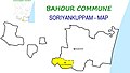
| Taluk | Bahour |
| Commune | Bahour |
| Population (2001) | |
• Total | 36,983 |
| Languages | |
| • Official | French, Tamil, English |
| Time zone | UTC+5:30 (IST) |
| PIN | 607 402 |
| Telephone code | 0413 |
| Vehicle registration | PY-01 |
| Sex ratio | 50% ♂/♀ |
Soriyankuppam is a village [1] in Bahour Commune of Bahour taluk in the Union Territory of Puducherry, India. Soriyankuppam serves as a bypass for Puducherry - Panruti route via Savadi. It lies on southern tip of Bahour Enclave of Puducherry district.